:quality(70)/arc-anglerfish-arc2-prod-cmg.s3.amazonaws.com/public/NCGUI27FE55GVRYJX5KGV6SBIM.png)
ORLANDO, Fla. — 9:30 p.m.
Showers and storms have come to and end across Central Florida. The evening will remain mostly cloudy, low temperatures in the low-70s.
Saturday will start off quiet, storms will return late in the evening and Alberto's rain bands become better formed.
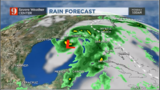
Subtropical storm Alberto continues moving erratically over the extreme northwestern Caribbean. Its general movement over the Yucatan Channel.
Chief meteorologist Tom Terry will update subtropical storm Alberto's track on Channel 9 Eyewitness News at 11 p.m.
7 p.m.
A tropical storm watch and a storm surge watch have been issued from the Florida Panhandle to Louisiana. There will be a high-risk for flooding in Central Florida.
Chief meteorologist Tom Terry will update subtropical storm Alberto's track on Channel 9 Eyewitness News.
Watch: Live Doppler 9 HD radar
Heavy outer rain bands/squalls from #Alberto will bring some heavy downpours starting late Saturday and on Sunday. Here's a look at the estimates through Sunday evening. More Monday! pic.twitter.com/1gShA9oU4V
— tom terry (@TTerryWFTV) May 25, 2018
5 p.m.
Tropical Storm Watches (and Storm Surge Watches) are out for the northern Gulf coast, including the Florida panhandle as #Alberto is forecast to approach land by late Sunday night. pic.twitter.com/xIaHTJdG1p
— tom terry (@TTerryWFTV) May 25, 2018
Storm Surge Watch: Horseshoe Beach to mouth of the Mississippi River. 2-4' along panhandle of FL pic.twitter.com/M3kzGGMPB1
— tom terry (@TTerryWFTV) May 25, 2018
4 p.m.
Storms have developed over Central Florida as moisture continues to move mainly from the south.
As rain chance increase (and grounds is well-saturated already) a flood watch is in effect for Sumter & Polk Co. until Monday. This area could be expanded. Still, some storms could produce some minor flooding this weekend, even if you are not under a flood watch.. stay weather aware.
Never, never drive through flooded roadways. Water might be deeper than expected.
— Irene Sans (@IreneSans) May 25, 2018
Tropical storm force winds to Central Florida are not likely, but rain will be the main impact.
Get some board games for the kids.. get them away from electronics & teach them your tricks! :) pic.twitter.com/XYVmVDnVgb
Storms will linger through the afternoon, some could produce around 2 inches of rain, as they move over Central Florida.
Alberto is stationary over the the northwestern Caribbean. It is expected to pick up speed, a bit, tonight and move over the Gulf of Mexico overnight into Saturday.
The storm's main impact to Central Florida (and the entire State) will be heavy rains. Some periods of calm weather can not be ruled out as the rains will come in waves. Some of the showers will be very heavy producing high rainfall in a short time. Although tropical storm force winds have a very low chance to be felt in the area, some embedded storms could produce over 40 mph gusts.
From Friday through Wednesday morning totals could reach 3 to 6 inches and some isolated areas could get over 8 inches. South Florida is looking wetter with rainfall reaching up to 8 inches and some areas over 10 inches of rain.
We will continue to monitor Alberto and all of its impacts to the State and bring you the latest on wftv.com, our newscasts and on our free WFTV Weather app.
First tropical storm watches are out for the resort areas of #Cancun #Cozumel, and for western #Cuba. #Alberto #EyeonTropics pic.twitter.com/zTYttrDB3y
— tom terry (@TTerryWFTV) May 25, 2018
10:30 a.m.
Subtropical Storm Alberto has officially formed over the Caribbean.
Alberto formed! It’s the 1st names storm of the 2018 hurricane season. Headed to the northern Gulf... pic.twitter.com/HizkRBX0Yn
— Brian Shields (@BrianWFTV) May 25, 2018
According to Channel 9 certified meteorologist Brian Shields, Alberto will stay to the west of Florida, bringing the most rain to Florida's west coast. Still, all of Central Florida should expect a wet weekend.
Subtropical Storm Alberto will make landfall in the northern Gulf (from Louisiana to the FL Panhandle) late Sunday or early Monday. The forecast for Central Florida stays the same! pic.twitter.com/d4oOttUf90
— Brian Shields (@BrianWFTV) May 25, 2018
Shields said expect the most rain Sunday, with an 80 percent chance of rain on Memorial Day. There will be times Saturday, Sunday and Monday when it is not raining, Shields said.
Tropical downpours coming our way! pic.twitter.com/xNRJD7PW4c
— Brian Shields (@BrianWFTV) May 25, 2018
Alberto's track! It'll make landfall in the Northern Gulf near Alabama early Monday with winds near 65 mph... pic.twitter.com/vYmf4w4raG
— Brian Shields (@BrianWFTV) May 25, 2018
5 a.m.
Very wet...at times! See ya on 9! pic.twitter.com/iPYibN7GXD
— Brian Shields (@BrianWFTV) May 25, 2018
Watch below: Brian Shields' 5-Day Forecast
Memorial Day: What could be Alberto will be west, but it will pump in on & off tropical rain! See you on Channel 9! pic.twitter.com/bFtZipJFZG
— Brian Shields (@BrianWFTV) May 25, 2018
Cox Media Group
:quality(70)/cloudfront-us-east-1.images.arcpublishing.com/cmg/WZ5DBKQBMBGJTNYMRNUIFSQM74.png)
:quality(70)/cloudfront-us-east-1.images.arcpublishing.com/cmg/O6CTDSZQZN7H3YRRN6SCUTFYO4.jpg)
:quality(70)/cloudfront-us-east-1.images.arcpublishing.com/cmg/ZRBUBVWFNJFXJP6ZQG2ANEROVE.png)
:quality(70)/cloudfront-us-east-1.images.arcpublishing.com/cmg/ELPLRWP63NCRHM26PJTYO7KO6Q.png)
:quality(70)/cloudfront-us-east-1.images.arcpublishing.com/cmg/WQ27IEQX4ZCSHHOV5SDI3RPS5I.jpg)