ORLANDO, Fla. — UPDATE:
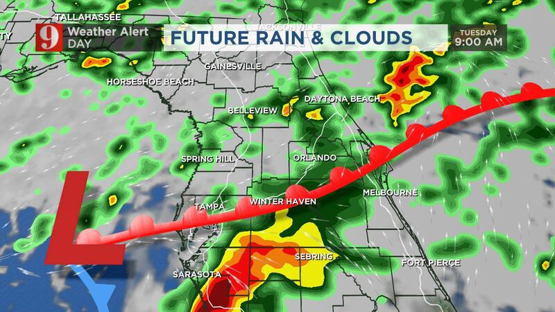
A broad storm system will move across Central Florida on Tuesday bringing with it the threat of severe storms. Storms will begin to move in around daybreak and become widespread through the morning hours as an area of low pressure moves overhead.
There's the storm system moving in tomorrow morning that will give all of Central Florida a risk of isolated severe storms through the afternoon. pic.twitter.com/SaO9rdQKCi
— Rusty McCranie (@RMcCranieWFTV) December 21, 2021
A cold front will then drag through Tuesday afternoon, keeping the threat for strong to severe storms ongoing through most of the afternoon. The main threat will be damaging winds with a very low tornado threat.
Flood Watch in effect for coastal Volusia and Brevard County until 4am tomorrow. Locally heavy rainfall could produce flooding of low-lying and poor drainage areas. 3-4" of rain is possible, with very isolated amounts that could be higher. pic.twitter.com/2lfr4zepMB
— Rusty McCranie (@RMcCranieWFTV) December 21, 2021
Read our previous story below:
The workweek will start out with hit-or-miss showers across Central Florida.
There will be extra clouds throughout the day.
>>> STREAM CHANNEL 9 EYEWITNESS NEWS LIVE <<<
>>> CLICK HERE FOR LIVE RADAR <<<
Daytime highs will be in the upper 70s. Orlando’s high is 77.
Monday night, more scattered showers will move through the area. Lows will be in the 60s.
Tuesday is a weather alert day. The best chance of rain will be in the early afternoon. Click here to download the WFTV weather app for updates to your phone, and click here to bookmark our live radar to see when the rain will be headed your way.
READ: Coronavirus: 44 people test positive for COVID-19 aboard Royal Caribbean cruise ship
Central Floridians can expect gusty winds and rain. There is also a possibility of an isolated tornado.
After Tuesday, it will dry out.
We will have a chilly Thursday morning.
READ: Christmas 2021 travel: Expect to pay more for just about everything, AAA says
Looking ahead, Christmas weather will be nice. Daytime highs are expected to be in the 70s.
Tuesday is a WEATHER ALERT DAY. You can see our storm system back to the west. I'm going over the severe weather threats, on Channel 9 now! pic.twitter.com/djVUGuMrFD
— Brian Shields, WFTV (@BrianWFTV) December 20, 2021
Follow our Severe Weather team on Twitter for live updates:
Visit our hurricane section: EYE ON THE TROPICS

Click here to download the free WFTV news and weather apps, click here to download the WFTV Now app for your smart TV and click here to stream Channel 9 Eyewitness News live.


