:quality(70)/arc-anglerfish-arc2-prod-cmg.s3.amazonaws.com/public/WJWY5ZTWC3XHVBIMBICGFWH4LA.jpg)
Watch: WFTV CH9 live newscasts | Watch Live: Doppler 9 HD
It will be a mostly sunny day across Central Florida Tuesday with a high temperature of 93 degrees.
While the forecast shows it will be a hotter day, there is a bit of good news: It won’t be as humid.
“Today will be hotter, but it won’t be super humid. Dry air is filtering in around Hurricane Humberto. Mid-90s are possible inland, but again, we won’t have our July-like humidity, so that helps some,” Severe Weather Center 9 meteorologist Brian Shields said.
EYE ON THE TROPICS: Tropical Depression 10 forms in the Atlantic
Download: WFTV news & weather apps | Hour-by-hour forecast
It will be mostly clear Tuesday night with a low temperature of 74 degrees.
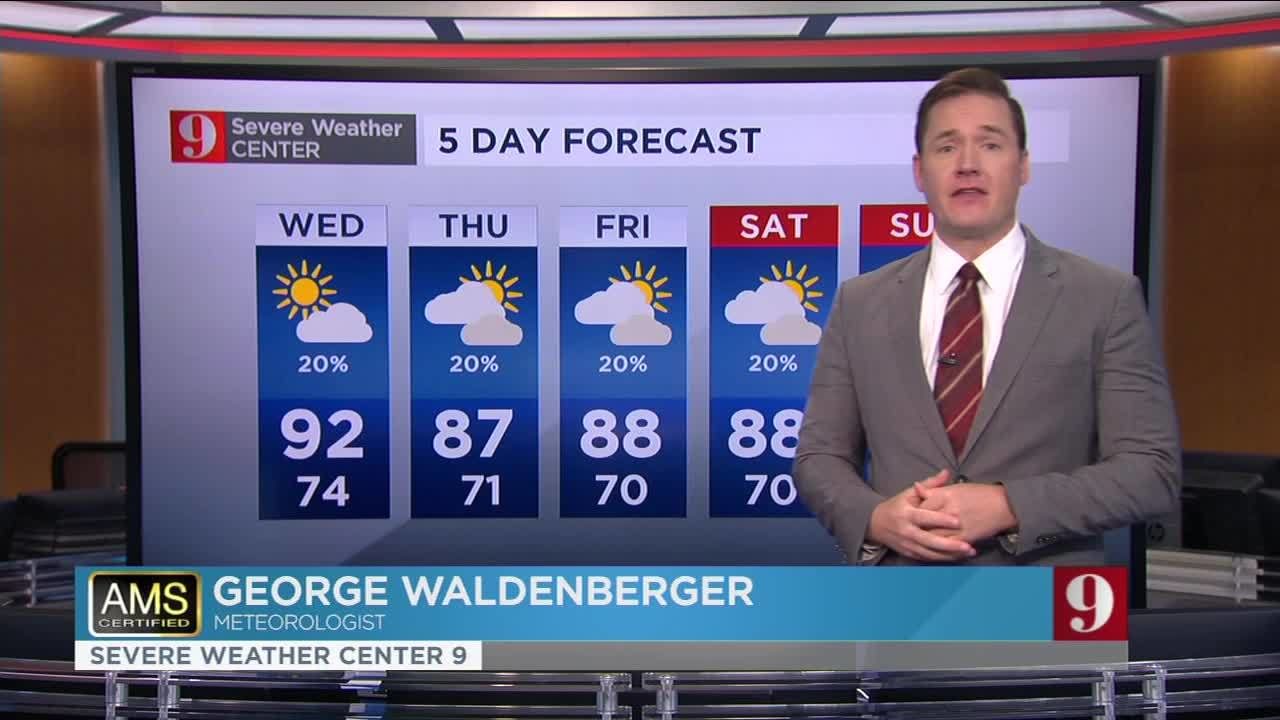
“Temperature will drop off on Thursday; middle 80s for highs. Not bad!” Shields said.
AT THE BEACH:
If you are heading to the beach, watch out for rip currents as the risk is high.
The National Weather Service said beach goers should expect 4-to 6-foot breaking waves that will add to the dangerous conditions.
“The longshore current will make swimming hazardous to all swimmers, regardless of experience,” NWS said. “If venturing into the water, only swim within sight of a lifeguard and do not swim alone.”
Heat exhaustion vs heatstroke: Know the difference, stay safe
WEDNESDAY’S OUTLOOK:
Partly cloudy with a chance of showers and a slight chance of thunderstorms. The average high temperatures will be in the upper 80s with a 50% chance of rain.
Check out your 5-Day Forecast below:
Follow our Severe Weather team on Twitter for live updates:
- Chief meteorologist Tom Terry
- Brian Shields
- Irene Sans
- Kassandra Crimi
- George Waldenberger
- Rusty McCranie
:quality(70)/mediaweb.wftv.com/photo/2018/11/08/APP%20DOWNLOAD%20WEX_1541693886850.jpg_13622063_ver1.0.jpg)
Cox Media Group
:quality(70)/cloudfront-us-east-1.images.arcpublishing.com/cmg/43ZYOPEFMJHLFI3OQ3B5OXWDZM.jpg)
:quality(70)/cloudfront-us-east-1.images.arcpublishing.com/cmg/LW2VP2Y6PJDZPLDJCDBZRFVCAI.png)
:quality(70)/cloudfront-us-east-1.images.arcpublishing.com/cmg/XCS5GJFEOFHDNEZGYXRYOZ35LM.jpg)
:quality(70)/cloudfront-us-east-1.images.arcpublishing.com/cmg/V5TWF6CJAZFXBLDTZXOE47OMN4.jpg)
:quality(70)/cloudfront-us-east-1.images.arcpublishing.com/cmg/JUYS26JO2NHPDBUAIOP62ZOR7A.jpeg)