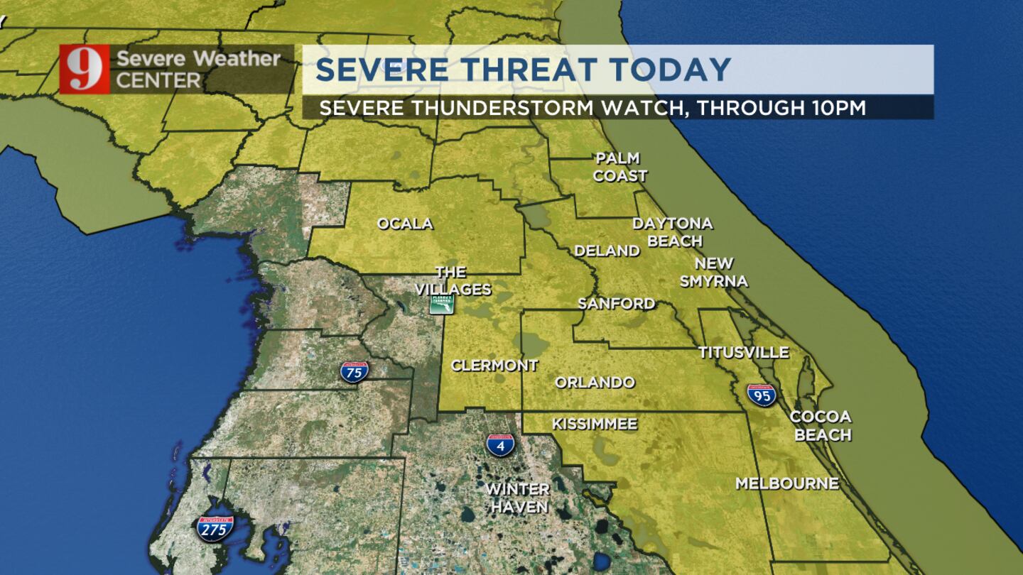
The strongest storms will bring the possibility of damaging winds and damaging hail.
“Similar to yesterday, hail will be our biggest concern,” meteorologist Kassandra Crimi said. “Cloud tops don’t look to be as cold as yesterday, but damaging hail reaching 1 to 1½” in size will be possible. These storms will also bring the potential for damaging winds and heavy downpours. When you see the skies darken or start to hear thunder, head indoors.”
Severe weather threat for Thursday (WFTV)
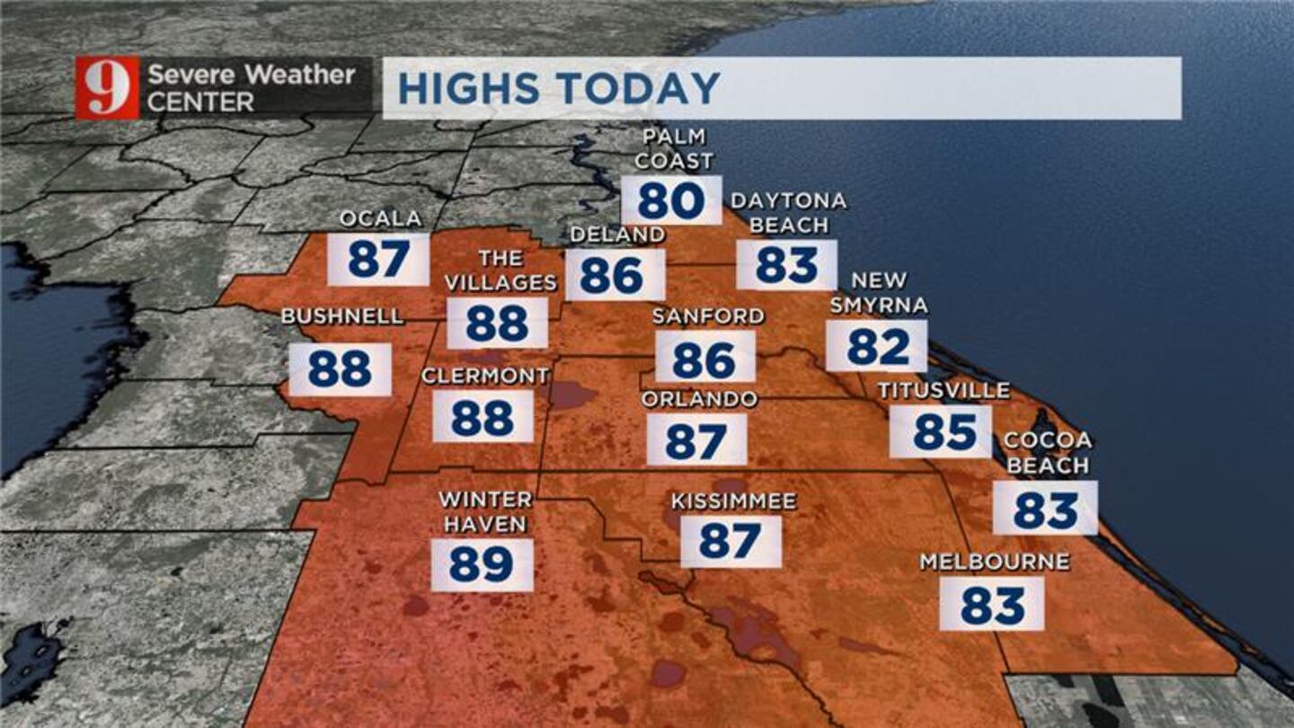
Afternoon forecast: Thursday, April 27 (WFTV)
Earlier story:
Strong thunderstorms are expected to roll into Central Florida on Thursday afternoon.
The region will see a 50% to 60% chance of scattered storms Thursday.
Some storms could be strong to severe with hail and gusty winds.
Hail in Central Florida Channel 9 viewers submitted their photos of hail in Central Florida, which pounded areas like West Melbourne and Palm Bay on Wednesday. (WFTV)
Hail in Central Florida Channel 9 viewers submitted their photos of hail in Central Florida, which pounded areas like West Melbourne and Palm Bay on Wednesday. (WFTV)
Hail in Central Florida Channel 9 viewers submitted their photos of hail in Central Florida, which pounded areas like West Melbourne and Palm Bay on Wednesday. (WFTV)
Hail in Central Florida Channel 9 viewers submitted their photos of hail in Central Florida, which pounded areas like West Melbourne and Palm Bay on Wednesday. (WFTV)
Hail in Central Florida Channel 9 viewers submitted their photos of hail in Central Florida, which pounded areas like West Melbourne and Palm Bay on Wednesday. (WFTV)
Hail in Central Florida Channel 9 viewers submitted their photos of hail in Central Florida, which pounded areas like West Melbourne and Palm Bay on Wednesday. (WFTV)
Hail in Central Florida Channel 9 viewers submitted their photos of hail in Central Florida, which pounded areas like West Melbourne and Palm Bay on Wednesday. (WFTV)
Hail in Central Florida Channel 9 viewers submitted their photos of hail in Central Florida, which pounded areas like West Melbourne and Palm Bay on Wednesday. (WFTV)
Hail in Central Florida Channel 9 viewers submitted their photos of hail in Central Florida, which pounded areas like West Melbourne and Palm Bay on Wednesday. (WFTV)
Hail in Central Florida Channel 9 viewers submitted their photos of hail in Central Florida, which pounded areas like West Melbourne and Palm Bay on Wednesday. (WFTV)
Hail in Central Florida Channel 9 viewers submitted their photos of hail in Central Florida, which pounded areas like West Melbourne and Palm Bay on Wednesday. (WFTV)
Hail in Central Florida Channel 9 viewers submitted their photos of hail in Central Florida, which pounded areas like West Melbourne and Palm Bay on Wednesday. (WFTV)
Hail in Central Florida Channel 9 viewers submitted their photos of hail in Central Florida, which pounded areas like West Melbourne and Palm Bay on Wednesday. (WFTV)
Hail in Central Florida Channel 9 viewers submitted their photos of hail in Central Florida, which pounded areas like West Melbourne and Palm Bay on Wednesday. (WFTV)
Hail in Central Florida Channel 9 viewers submitted their photos of hail in Central Florida, which pounded areas like West Melbourne and Palm Bay on Wednesday. (WFTV)
Hail in Central Florida Channel 9 viewers submitted their photos of hail in Central Florida, which pounded areas like West Melbourne and Palm Bay on Wednesday. (WFTV)
Hail in Central Florida Channel 9 viewers submitted their photos of hail in Central Florida, which pounded areas like West Melbourne and Palm Bay on Wednesday. (WFTV)
Hail in Central Florida Channel 9 viewers submitted their photos of hail in Central Florida, which pounded areas like West Melbourne and Palm Bay on Wednesday. (WFTV)
Hail in Central Florida Channel 9 viewers submitted their photos of hail in Central Florida, which pounded areas like West Melbourne and Palm Bay on Wednesday. (WFTV)
Hail in Central Florida Channel 9 viewers submitted their photos of hail in Central Florida, which pounded areas like West Melbourne and Palm Bay on Wednesday. (WFTV)
Hail in Central Florida Channel 9 viewers submitted their photos of hail in Central Florida, which pounded areas like West Melbourne and Palm Bay on Wednesday. (WFTV)
Hail in Central Florida Channel 9 viewers submitted their photos of hail in Central Florida, which pounded areas like West Melbourne and Palm Bay on Wednesday. (WFTV)
Hail in Central Florida Channel 9 viewers submitted their photos of hail in Central Florida, which pounded areas like West Melbourne and Palm Bay on Wednesday. (WFTV)
Hail in Central Florida Channel 9 viewers submitted their photos of hail in Central Florida, which pounded areas like West Melbourne and Palm Bay on Wednesday. (WFTV)
Hail in Central Florida Channel 9 viewers submitted their photos of hail in Central Florida, which pounded areas like West Melbourne and Palm Bay on Wednesday. (WFTV)
Hail in Central Florida Channel 9 viewers submitted their photos of hail in Central Florida, which pounded areas like West Melbourne and Palm Bay on Wednesday. (WFTV)
Hail in Central Florida Channel 9 viewers submitted their photos of hail in Central Florida, which pounded areas like West Melbourne and Palm Bay on Wednesday. (WFTV)
Hail in Central Florida Channel 9 viewers submitted their photos of hail in Central Florida, which pounded areas like West Melbourne and Palm Bay on Wednesday. (WFTV)
Hail in Central Florida Channel 9 viewers submitted their photos of hail in Central Florida, which pounded areas like West Melbourne and Palm Bay on Wednesday. (WFTV)
Hail in Central Florida Channel 9 viewers submitted their photos of hail in Central Florida, which pounded areas like West Melbourne and Palm Bay on Wednesday. (WFTV)
Hail in Central Florida Channel 9 viewers submitted their photos of hail in Central Florida, which pounded areas like West Melbourne and Palm Bay on Wednesday. (WFTV)
Hail on I-95 Hail is falling on I-95 in Brevard County. (FDOT)
Hail in Central Florida Channel 9 viewers submitted their photos of hail in Central Florida, which pounded areas like West Melbourne and Palm Bay on Wednesday. (WFTV)
Hail in Central Florida Channel 9 viewers submitted their photos of hail in Central Florida, which pounded areas like West Melbourne and Palm Bay on Wednesday. (WFTV)
Hail in Central Florida Channel 9 viewers submitted their photos of hail in Central Florida, which pounded areas like West Melbourne and Palm Bay on Wednesday. (WFTV)
Hail in Central Florida Channel 9 viewers submitted their photos of hail in Central Florida, which pounded areas like West Melbourne and Palm Bay on Wednesday. (WFTV)
Hail in Central Florida Channel 9 viewers submitted their photos of hail in Central Florida, which pounded areas like West Melbourne and Palm Bay on Wednesday. (WFTV)
Hail in Central Florida Channel 9 viewers submitted their photos of hail in Central Florida, which pounded areas like West Melbourne and Palm Bay on Wednesday. (WFTV)
Hail in Central Florida Channel 9 viewers submitted their photos of hail in Central Florida, which pounded areas like West Melbourne and Palm Bay on Wednesday. (WFTV)
Hail in Central Florida Channel 9 viewers submitted their photos of hail in Central Florida, which pounded areas like West Melbourne and Palm Bay on Wednesday. (WFTV)
Hail in Central Florida Channel 9 viewers submitted their photos of hail in Central Florida, which pounded areas like West Melbourne and Palm Bay on Wednesday. (WFTV)
Hail in Central Florida Channel 9 viewers submitted their photos of hail in Central Florida, which pounded areas like West Melbourne and Palm Bay on Wednesday. (WFTV)
Hail in Central Florida Channel 9 viewers submitted their photos of hail in Central Florida, which pounded areas like West Melbourne and Palm Bay on Wednesday. (WFTV)
Hail in Central Florida Channel 9 viewers submitted their photos of hail in Central Florida, which pounded areas like West Melbourne and Palm Bay on Wednesday. (WFTV)
Hail in Central Florida Channel 9 viewers submitted their photos of hail in Central Florida, which pounded areas like West Melbourne and Palm Bay on Wednesday. (WFTV)
Hail in Central Florida Channel 9 viewers submitted their photos of hail in Central Florida, which pounded areas like West Melbourne and Palm Bay on Wednesday. (WFTV)
Hail in Central Florida Channel 9 viewers submitted their photos of hail in Central Florida, which pounded areas like West Melbourne and Palm Bay on Wednesday. (WFTV)
Hail in Brevard County (Burst)
Hail in Brevard County (Burst)
Hail in West Melbourne (ErinAlvarado94)
Brevard County hail (Burst)
Hail on I-95 Hail is falling on I-95 in Brevard County. (WFTV Staff)
Hail in West Melbourne (Burst)
Hail in West Melbourne (Burst)
Hail in West Melbourne (Burst)
Hail in West Melbourne (Burst)
Brevard County hail (Burst)
Hail on I-95 Hail is falling on I-95 in Brevard County. (FDOT)
Morning forecast: Thursday, April 27 (WFTV)
Afternoon storms chances stay active Thursday in Central Florida