>>Click here to watch our 24/7 Weather stream<<
Bookmark this page to get the latest updates on the storm’s track.
BLOG EN ESPAÑOL: Isaías como tormenta tropical, trayectoria se aleja más de la costa este de Florida
ORLANDO, Fla. — See LIVE updates below:
8 p.m. update
Brevard County’s beaches fared pretty well, but there were still some signs of erosion.
See the video below:

2:10 p.m. update
Chief meteorologist Tom Terry said Tropical Storm Isaias could strengthen back into a hurricane Monday.
Terry said the storm has shown better organization.
He said the Atlantic will likely calm down through Aug. 10 due to higher pressure and a more stable environment.
By mid to late August, the trend is opposite, Terry said.
The fact that our live doppler east of Orlando is getting a pretty good image of the center of #Isaias at this distance is another sign of the storm's better organization. Could become a hurricane again later today. #EyeonTropics pic.twitter.com/1B9HXVbPOm
— Tom Terry (@TTerryWFTV) August 3, 2020
After #Isaias, the Atlantic likely calming down through Aug 10th according to the GFS. The red colors denote higher pressures and a more stable environment. By mid-late August the trend is opposite, so we'll be watching! #EyeonTropics pic.twitter.com/O3q1acqCj4
— Tom Terry (@TTerryWFTV) August 3, 2020
8:10 a.m. update
The sun is coming out in New Smyrna Beach as Tropical Storm Isaias continues to move along Florida’s coast.
Tropical Storm Isaias is moving north toward the Carolinas at 13 mph, with winds of 70 mph.
The storm could strengthen into a hurricane before it reaches the Carolinas Monday.
Flagler County is the last Central Florida county to feel some effects of Isaias. Wind and rain have moved through the area but there is no sign of major damage to the area.
Rough surf is expected to last throughout the day.
Here comes the ☀️ in New Smyrna Beach @WFTV pic.twitter.com/i5ahdg2IfB
— Sarahbeth Ackerman (@SAckermanWFTV) August 3, 2020
6 a.m. update
Tropical Storm Isaias crawling north toward Carolinas, could strengthen into hurricane
Tropical Storm Isaias continues to crawl north at 9 mph. Its winds are about 70 mph as it moves toward the Carolinas. The storm could strengthen into a hurricane before it reaches the Carolinas.
In Central Florida, the storm didn’t make any major impacts on the area. Most areas saw winds pick up as showers moved throughout the region.

5:05 a.m. update
Tropical Storm Isaias crawling north, nearing Jacksonville coast
Tropical Storm Isaias is continuing to move north along Florida’s coast. The storms winds have reached 70 mph as it moves north at 9 mph.
4:10 a.m. update
Wind picks up in Volusia County
Channel 9 reporter Cierra Putman said the wind has picked up in Volusia County.
She sai she was able to cross a bridge to get to a shelter location on the Halifax River. County officials said they will close the bridges if they get to 39 mph sustained winds.
Good morning! The wind has picked up here in #volusiacounty but still not too bad. We crossed one of the bridges to get to a sheltered live location on the intracoastal/Halifax River. @VCEmergencyInfo said it will close the bridges if they get 39mph sustained winds @WFTV #Isais pic.twitter.com/vUDT8ibByb
— Cierra Putman WFTV (@CPutman_WFTV) August 3, 2020
As of the 2 a.m. update, Isaias remains a tropical storm and it continues its path along Florida’s coast.
2 a.m. update
Tropical Storm Isaias will continue to bring stormy conditions to coastal counties
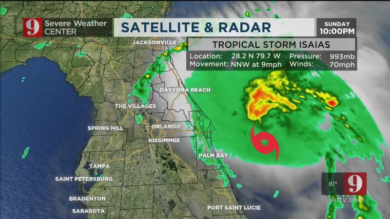
Tropical Storm Isaias continues to move slowly at 9 mph. It’s located about 55 miles from Cape Canaveral. Isaías will continue to bring tropical storm gusts to coastal counties. But sustained tropical storm-force winds will remain out over sea. In fact, the strongest winds and storms will continue east of the storm, well away from Florida.
The windier conditions will persist for the next few hours before Isaías begins to move faster northward and make a slight turn north-northeast. Winds are expected to pick up over the South Carolina coast. The storm is expected to make landfall early Tuesday morning near the South Carolina-North Carolina border.
1 a.m. update
Isaias to gain hurricane strength while shifting toward Carolinas
Tropical Storm Isaias is expected to be near hurricane strength when it reaches the Carolinas.
Tropical Storm #Isaias Advisory 24: Isaias Expected to Be Near Hurricane Strength When it Reaches The Carolinas. https://t.co/VqHn0u1vgc
— National Hurricane Center (@NHC_Atlantic) August 3, 2020
Cox Media Group


