ORLANDO, Fla. — The evening will continue rain-free and low temperatures will be int he low-70s.
There will be more moisture moving over Central Florida from the south starting Friday afternoon which will produce showers and scattered thunderstorms. Much deeper moisture will move into over the next holiday weekend.
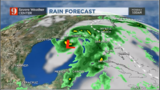
The forecast has not changed since this afternoon's update. Periods of heavy showers starting late Saturday afternoon continuing through the weekend. We could also have some rain-free period if a dry slot moves over Florida. So don't expect a total washout, but some of the showers will be heavy and could easy produce flooding. There will likely be a flood watch issue for the weekend Friday or Saturday morning. Please stay tuned for the forecast and have your WFTV Weather app, it will notify you as soon as a watch or warning is issued.
Watch the timing of the storms and how much rainfall we can expect below, by our certified meteorologist Irene Sans
3:25 p.m.
Very summer-like pattern continues today without the storms in the afternoon. Expect the clouds to build over Central Florida during this afternoon, with a low chance for some late afternoon light inland showers. Tonight partly to mostly cloudy skies, humid, with temperatures falling to the low-70s.
Friday
Showers will develop starting around noon, very scattered and there is a chance for afternoon storms across Central Florida.
Is the tropical disturbance receives a name, it will likely not happen Friday morning (latest Friday afternoon), as it is still approaching the Yucatan Peninsula and it will continue to travel over the Yucatan Thursday evening.
Conditions are becoming more favorable for this system to get a name, which in this case would be Alberto.
Regardless of development, the convection of this system will be mainly focused over its eastern side, which makes Florida and the southeastern U.S its bulls-eye. High rainfall chances extend from Florida to the Gulf States.
Chance of formation up to 90%. Central FL, no change to forecast. Expect rain through Memorial Day weekend #FLwx pic.twitter.com/Mo3o6tXCGk
— Eboni Deon, WSB (@EboniDeonWSB) May 24, 2018
Weekend's forecast
The weekend is looking wetter as the deeper tropical moisture will enter the area mainly from the south. Saturday morning and afternoon will be mostly calm with the chance for showers and storms increasing through the afternoon into the evening hours.
Heavy showers and storms will affect Central Florida, which could lead to minor flooding during this period. Sunday will be overcast with heavier intermittent showers and storms all day. High temperatures will stay in the upper-70s to lower-80s Sunday afternoon courtesy of the deep layers of clouds, showers and storms.
Monday will remain mostly cloudy with a high chance to have coverage across more than half of Central Florida. Intermittent showers and storms will continue to affect the area, with increasing flooding chances.
If the system will have some filtered dry slots once it gets to the Gulf of Mexico. If it moves a bit more east we could get luckily and have more breaks from the rain. But this is extremely hard to forecast at the moment since the systems still does not have a well-defined center of circulation and is approaching land. We will continue to monitor the tropical disturbance and bring you the latest on WFTV.com, our newscasts and through out free WFTV Weather app.
:quality(70)/d1hfln2sfez66z.cloudfront.net/11-13-2019/t_8ea00c3ab4d6480f83c70bb0d78022b6_name_F9331FEF1ACC43D28B7F4B5C1EAF48A6_2.jpg)
The developing disturbance...90L
— George Waldenberger (@GWaldenWFTV) May 24, 2018
Likely to form into a (sub)tropical depression...
May become Alberto...
But its next name will likely be 'Potential Tropical Cyclone'... pic.twitter.com/glWhMQv0uX
What could become "Alberto" will keep the rain coming through the holiday weekend for central FL. On an off again wet times. #FLwx pic.twitter.com/BYSf4Cq9wg
— Eboni Deon, WSB (@EboniDeonWSB) May 24, 2018
Watch below: Meteorologist Brian Shields' 5-day forecast
- Saturday: 70 percent rain chance
- Sunday: 90 percent rain chance
- Monday: 80 percent rain chance
The flood threat gets higher this weekend: wftv.com/weather & wftvapps.com
Posted by WFTV Channel 9 on Thursday, May 24, 2018
The developing disturbance...90L
— George Waldenberger (@GWaldenWFTV) May 24, 2018
Likely to form into a (sub)tropical depression...
May become Alberto...
But its next name will likely be 'Potential Tropical Cyclone'... pic.twitter.com/glWhMQv0uX
The developing disturbance...90L
— George Waldenberger (@GWaldenWFTV) May 24, 2018
Likely to form into a (sub)tropical depression...
May become Alberto...
But its next name will likely be 'Potential Tropical Cyclone'... pic.twitter.com/glWhMQv0uX
Chance of formation up to 90%. Central FL, no change to forecast. Expect rain through Memorial Day weekend #FLwx pic.twitter.com/Mo3o6tXCGk
— Eboni Deon WFTV (@ebonideonwftv)
Chance of formation up to 90%. Central FL, no change to forecast. Expect rain through Memorial Day weekend #FLwx pic.twitter.com/Mo3o6tXCGk
— Eboni Deon, WSB (@EboniDeonWSB) May 24, 2018
Cox Media Group
:quality(70)/cloudfront-us-east-1.images.arcpublishing.com/cmg/IJMIFE2ICBAUBIN43BQCUVHU7Y.jpg)
:quality(70)/cloudfront-us-east-1.images.arcpublishing.com/cmg/HMWCPQ3BJ5GIHGSZSPR7M5ELQ4.jpeg)
:quality(70)/cloudfront-us-east-1.images.arcpublishing.com/cmg/PEBDMQUI2ZGKZOLPSILEAM2AUQ.jpg)
:quality(70)/cloudfront-us-east-1.images.arcpublishing.com/cmg/7KSZR37X4VFXJEOIQMSE2YC3MI.jpg)
:quality(70)/cloudfront-us-east-1.images.arcpublishing.com/cmg/BAILPLZUL5GTHGZMMMO7IWDYF4.jpg)