ORLANDO, Fla. — 8 p.m. update:
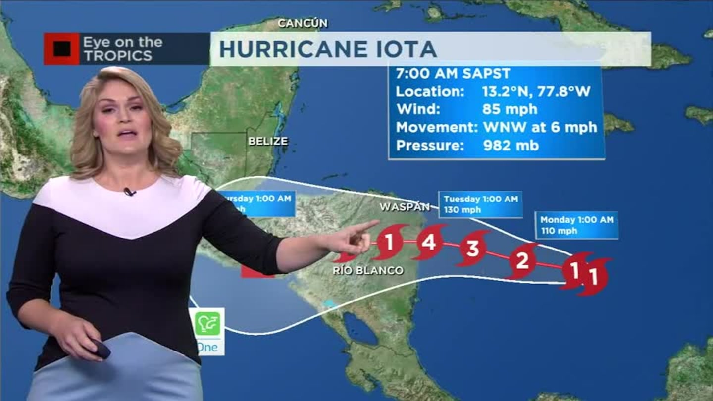
Iota has strengthened into a Category 2 hurricane.
The storm is expected to bring potentially catastrophic winds, life-threatening storm surge and extreme rainfall impacts to Central America.
Hurricane #Iota Advisory 10A: Iota Strengthens to a Category 2 Hurricane. Expected to Bring Potentially Catastrophic Winds, Life- Threatening Storm Surge, and Extreme Rainfall Impacts To Central America. https://t.co/VqHn0u1vgc
— National Hurricane Center (@NHC_Atlantic) November 15, 2020
Update:
Now a Category 1 storm, Hurricane Iota is expected to intensify rapidly before making landfall in Central America.
Iota is forecast to land between Nicaragua and Honduras early in the week. That would be the second hurricane landfall in the area in a matter of weeks.
Unlike Eta, Iota is not expected to make a turn to the north towards Florida.
Update:
The tropics remain active as the 2020 hurricane season continues to break records after we reach our 30th named storm of the year.
Tropical Storm Iota will gain strength this weekend as it moves through the Western Caribbean and approaches Central America.
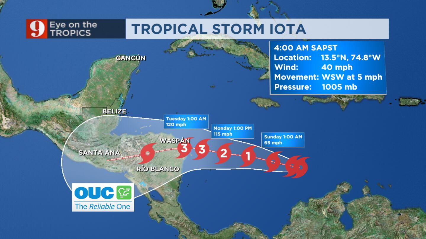
Iota is expected to make landfall near the Nicaragua and Honduras border early Tuesday morning as a major hurricane. This would happen almost exactly 2 weeks after Eta made landfall in Nicaragua as a major category 4 hurricane.
Read: Warm temperatures and partly cloudy skies expected Saturday
The 2020 hurricane season is officially the most active season ever, holding the record for the most named systems in a single season since the 19th century when records began. The 2005 hurricane season had the previous record with 28 named systems.
Previous story:
Tropical Depression 31 is now Tropical Storm Iota -- the 30th named storm of the season.
Major hurricane impacts are expected in northern Nicaragua and Honduras by Monday, chief meteorologist Tom Terry said.
This will be back-to-back major hurricanes hitting this area in the past week, he said.
Terry said he does not expect Iota to move north after landfall.
Click here to watch Terry’s updated forecast LIVE on Channel 9 Eyewitness News.
Click here to download the free WFTV weather app.
Record 30th named storm #Iota is official. Major hurricane impacts are expected in northern Nicaragua and Honduras by Monday. This will be back-to-back majors hitting this area in the past week. Ugg. No expectation of it moving north after landfall. #eyeontropics pic.twitter.com/DsAyVj0yXC
— Tom Terry (@TTerryWFTV) November 13, 2020
TROPICAL DEPRESSION 31
A robust tropical wave travels west over the Caribbean and it has officially been labeled as Tropical Depression 31.
This system will be coming closer to Central America, where Hurricane Eta brought devastation and hundreds of deaths. The next name in the list is Iota, the ninth name in the Greek Alphabet.
It is likely that the National Hurricane Center will issue hurricane watches for parts of Central America tonight.
Most models indicate that the system will continue moving west-northwest, heading toward Honduras during the early part of next week, likely as a hurricane.
This will become #Iota, likely very soon.
— Irene Sans (@IreneSans) November 13, 2020
This is a very dangerous path, and even more dangerous now because they are still dealing with the aftermath of #Eta.
Read more: https://t.co/QIIBgCuEP0 pic.twitter.com/tFGURb5MBy
Read: What do they mean? Disturbance, depressions, tropical, subtropical storms, hurricanes
For now, the rain chance will increase through the weekend and heavier rains and storms for early next week across the same areas affected by Eta.
Deep tropical moisture arrives this weekend and the winds will likely start to increase by late Sunday. We will monitor this system closely through the weekend and bring you the latest on Eyewitness News, on WFTV.com and on our free WFTV Weather App.
Read more: Tropical Storm versus Category 1 Hurricane: What’s the difference?
Another cyclone (likely a cat 2, or 3 hurricane) is heading to Central America. Most models in agreement that it will be closer to #Honduras early next week. Lots of Tropical moisture this weekend. https://t.co/XCj5TYKmfA
— Irene Sans (@IreneSans) November 13, 2020
Tropical Storm Theta over the eastern Atlantic
Theta is located well south of the Azores Islands, and it is forecast to lose its tropical characteristics by the end of this weekend.
By late Sunday, Theta will also start to weaken and make a turn to the north. Once the shift in direction happens the system will likely gain some speed. Some models are calling for this system to become a depression by Tuesday.
See more: 9 facts about flooding
Follow our Severe Weather team on Twitter for live updates:
- Chief meteorologist Tom Terry
- Brian Shields
- Irene Sans
- Kassandra Crimi
- George Waldenberger
- Rusty McCranie
Cox Media Group


