
ORLANDO, Fla. — Severe storms hit Central Florida on Wednesday afternoon as many began their commute home.
Downpours, lightning, small hail and downed tree limbs were reported.
>>> STREAM CHANNEL 9 EYEWITNESS NEWS LIVE <<<
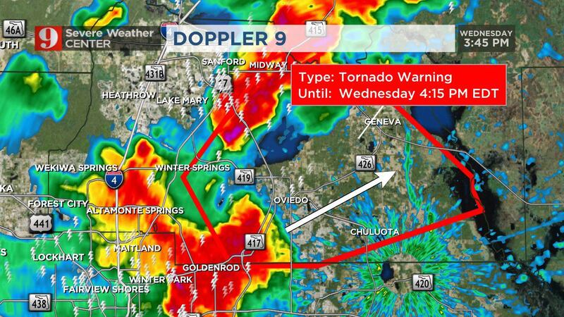
A tornado warning was issued for the Oviedo area of Seminole County, but it has since expired.
Storms will shift east of Orlando through dinnertime before moving into Brevard County.
Some lingering showers are possible for Wednesday evening.
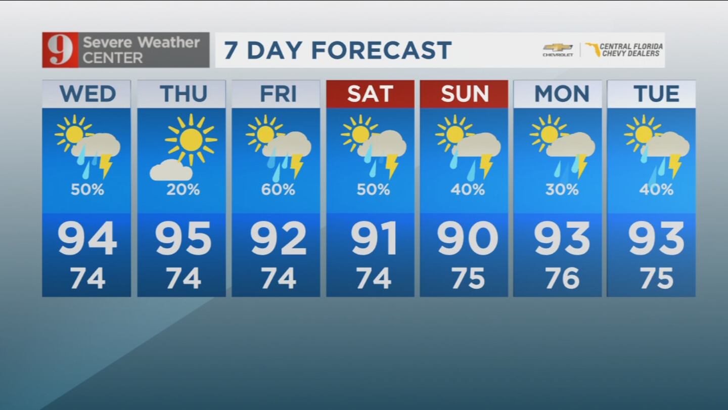
Storms will be more isolated Thursday, but expect a more widespread pattern Friday and during the weekend.
Severe storms hit Central Florida on Wednesday afternoon as many began their commute home.
Click here to stream live coverage.
4:15 p.m. update
A tornado warning issued for Seminole County has expired and weather conditions have weakened.
Watch live coverage now on Channel 9 Eyewitness News.
3:55 p.m. update
A tornado warning has been issued for Seminole County.
The warning will last until 4:15 p.m. and is primarily affecting Casselberry, Sanford, Winter Springs and Oviedo.
Chief meteorologist Tom Terry and certified meteorologist George Waldenberger are tracking the system live on Channel 9 Eyewitness News. Click here to stream live coverage.
Terry said the storm could develop a “lake spout,” which is not an uncommon occurrence.
He said it is crucial for residents to take shelter in the lowest, most central part of their homes.
Tornado warning Seminole County. pic.twitter.com/L2VaQSO8BA
— George Waldenberger (@GWaldenWFTV) June 8, 2022
Earlier story:
Wednesday will start off hot with mostly sunny skies.
Scattered showers and thunderstorms will develop as we move into the afternoon with highs near 94 degrees.
Read: Governor signs legislation to improve school safety in Florida
Active seabreeze pattern this afternoon. Numerous showers and storms expected. Here are the impacts. pic.twitter.com/uEd5kfXdq9
— Rusty McCranie (@RMcCranieWFTV) June 8, 2022
Going into Thursday, expect sunny skies for much of the morning and a 20% chance of afternoon thunderstorms.
The day’s highest temperature will be in the mid-90s.
Read: Florida man bitten by an alligator he mistook for a dog
As we head into the weekend, temperatures will remain in the 90s with an increased chance of afternoon storms.
Follow our Severe Weather team on Twitter for live updates:
Visit our hurricane section: EYE ON THE TROPICS
Click here to download the free WFTV news and weather apps, click here to download the WFTV Now app for your smart TV and click here to stream Channel 9 Eyewitness News live.


