ORLANDO, Fla. — A line of storms brought two confirmed tornado and severe weather across Central Florida on Monday. Areas saw damaging wind gusts, hail and other dangerous conditions.
>> CLICK HERE TO WATCH LIVE DOPPLER 9 <<<
>>WE ARE LIVE TRACKING STORMS, TUNE IN HERE<<
If you have any videos or photos you want to share, use the Share With Us tab at wftv.com
Here are some of photos and videos of storm damage we’re seeing:
6:20 p.m.
So far only 2 tornadoes have been confirmed on Monday.
One was the Ef-0 tornado in Marion by the National Weather Service office in Jacksonville, and the other one was a visual confirmation of the tornado in Seminole County.
Although there was rotation noted on radar shortly before noon on Monday over Volusia county, the has not been a visual confirmation and the National Weather Service in Melbourne will survey the area on Tuesday to confirm if a tornado might have touched down in the county, or not.
Our certified digital meteorologist Irene Sans, confirmed with The National Weather Service office in Melbourne and they will survey Volusia county and Seminole county tomorrow. Since there were several visuals on the Seminole Tornado from viewers, it is confirmed that it was a tornado but a classification will not be given since they have not evaluated any damages.
Two tornadoes confirmed in Central Florida today:
— Irene Sans (@IreneSans) April 20, 2020
✅Visual confirmation on the Seminole Co. Tornado (not classified yet)@NWSMelbourne will survey damages tomorrow in Seminole & Volusia.
✅Damage, visual confirmation, and surveyed by @NWSJacksonville EF-0 tornado in Marion Co. pic.twitter.com/j2qyst3o4W
5 p.m. update
Tornado in Marion county was confirmed by the National Weather Service in Jacksonville to be an EF-0 with peak winds at 85 mph.
Numerous trees were snapped and a trailer was lifted. No injuries were reported.
. @NWSJacksonville (very quickly) confirms tornado in #marion county. Traveled 11.5 miles.
— Irene Sans (@IreneSans) April 20, 2020
Snapped several trees and lifting a stationary construction trailer.
This is where @GWaldenWFTV reported live from during our noon newscast. @WFTV pic.twitter.com/SM4wFgxx3p
2:40 p.m. update
WFTV Skywitness 9 flew over tornado damage Monday afternoon in Marion County.
0 of 7


See the weather forecast for the rest of this Monday across Central Florida
2:12 p.m. update
Orlando Sanford International Airport shared a photo and video showing a tornado only a few miles away from the airport this morning.
Up close at personal from SFB! Footage from earlier this morning from a tornado a few miles from the airport. We were able to get a great video #TornadoWatch 🌪 pic.twitter.com/ZQyTQwvtor
— Orlando Sanford International Airport (@SFB_Airport) April 20, 2020
1:35 p.m. update
WFTV reporter Jeff Levkulich shot video of storms moving towards Geneva out of Sanford.
Storm heading towards Geneva out of Ssnford. #WFTV @BrianWFTV @TTerryWFTV #WFTV pic.twitter.com/VE4lcEb0Eq
— Jeff Levkulich (@jlevkulichWFTV) April 20, 2020
1:25 p.m. update
Video shared by the City of DeLand shows severe weather near City Hall. There are also photos showing downed tree limbs and reports of downed power lines.
More video of the storm coming through this morning. This is looking south toward the police department. pic.twitter.com/hDDXnPzUrw
— City of DeLand (@CityofDeLand) April 20, 2020
Here’s another view from City Hall as the storm came through this morning. This is a view of our parking just to the south. pic.twitter.com/xmkS3ki2oQ
— City of DeLand (@CityofDeLand) April 20, 2020
Here's some footage of the storm coming through this morning from City Hall. Damage appears to be isolated to southwest DeLand. Duke Energy reported about 300 customers without power - 10 calls are related to power lines and trees down. pic.twitter.com/YbfVzOurQw
— City of DeLand (@CityofDeLand) April 20, 2020
Crews are out assessing damage from the storm that just passed through. Receiving reports of tree limbs and power lines down. If you see a downed lines do not approach it as it may still be active. pic.twitter.com/92HNzL2W00
— City of DeLand (@CityofDeLand) April 20, 2020
1:15 p.m. update
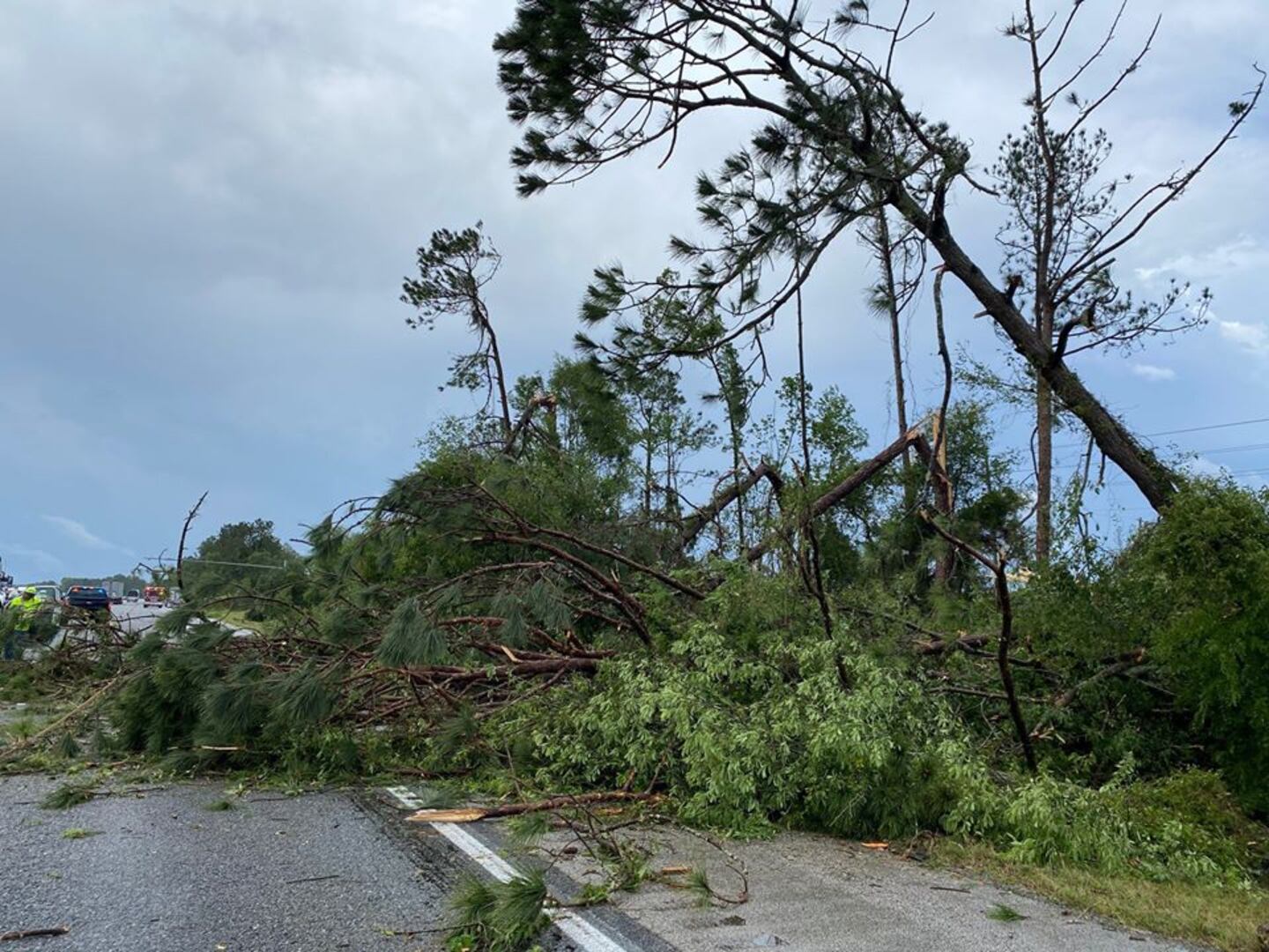
The Marion County Sheriff’s Office shared photos of trees down and debris on southbound I-75 in Marion County near the Highway 484 exit. Two lanes were closed as crews cleaned up the damage.
Click here to download the free WFTV weather app, and watch your five-day forecast below:
DOWNLOAD OUR FREE WFTV WEATHER APP TO RECEIVE ALERTS
1:05 p.m. update
A WFTV viewer shared this video near Lake Jesup in Seminole County.
Near Lake Jessup...RT @Mike5500: @WFTVWeather pic.twitter.com/bp1mpR4I7g
— Brian Shields (@BrianWFTV) April 20, 2020
12:55 p.m. update
Seminole County shared video of a tornado south of Boombah Sports Complex.
Seminole County has been in contact with @NWSMelbourne to determine what type of weather system was spotted south of Boombah Sports Complex. pic.twitter.com/Kkywi14j2r
— Seminole County, FL (@seminolecounty) April 20, 2020

12:40 p.m. update
WFTV meteorologist George Waldenberger reports shredded trees and other storm damage along I-75, south of Ocala in Marion County.
Driveway off 20th avenue road after storms passed, trees down everywhere, owners ok but baby goat missing. #WFTV #FLORIDA pic.twitter.com/UeR54zviLv
— George Waldenberger (@GWaldenWFTV) April 20, 2020
Shredded trees everywhere as reports of a tornado crossed I-75 just south of Ocala. pic.twitter.com/egZLTFnSvt
— George Waldenberger (@GWaldenWFTV) April 20, 2020
Storm damage along I-75 south of Ocala, near County Road 484. #Florida pic.twitter.com/C93te2EYHp
— George Waldenberger (@GWaldenWFTV) April 20, 2020

© 2020 Cox Media Group


