ORLANDO, Fla. — There’s a risk for severe weather Thursday in Central Florida due to a strong storm system set to move through the area.
>>> STREAM CHANNEL 9 EYEWITNESS NEWS LIVE <<<
>>> DOWNLOAD THE FREE WFTV WEATHER APP <<<
See live updates below:
1:50 p.m. update:
Storms producing gusty winds are moving through Orange County. There is a tornado watch in effect through 4 p.m. mainly along and east of Interstate 4.
Lots of gustiness along this line of storms moving east at 30mph. #WeatherAlertDay Tornado watch until 4pm mainly along and east of I-4 now. pic.twitter.com/Sh5LSQLHIX
— Tom Terry (@TTerryWFTV) December 15, 2022
12:58 p.m. update:
FAA officials have confirmed the storm system has caused a ground stop to be issued at Orlando International Airport.
Airport leaders said the storm may impact flights and baggage movement at OIA.
Weather Alert ⛈️ Due to current weather conditions, flights/baggage delivery delays may occur. Please check with your airline directly for any updates in regards to their operations at this time. For airport delays, visit: https://t.co/vm0yMYpINV
— Orlando International Airport (@MCO) December 15, 2022
It’s unclear how many flights may be impacted by the storm and ground stop.
11:22 a.m. update:
A tornado warning issued for Sumter County has ended, but Central Florida counties remain under a tornado watch.
Click here to download our free news and weather apps.
11 a.m. update:
A tornado warning has been issued for Sumter County.
Take cover in the lowest, most central room in your home. And stay away from windows.
Tornado Warning Take action now if you are in shaded area.
— Kassandra Crimi (@KCrimiWFTV) December 15, 2022
A tornado has been detected. Go to the lowest, most central room in your home. Stay away from windows. Hernando, Pasco, Sumter #StormAlert9 pic.twitter.com/L8wQmLWVfp
9 a.m. update:
When a violent storm is brewing and you start to see tornado “warning” and tornado “watch” splashed across your TV screen and devices, it can be confusing in the heat of the moment to determine what that means.
TORNADO WATCH UNTIL 4 PM ——
— Brian Shields, WFTV (@BrianWFTV) December 15, 2022
A strong line of storms will move into our western zones late morning, and for the rest of us, this afternoon. Damaging winds and isolated tornadoes possible.
If warnings are issued, tune to Channel 9.
Please stay aware today. Be safe! - Brian pic.twitter.com/f9UZDC8JAJ
According to The National Weather Service, a tornado “warning” is issued when a tornado is imminent. Usually that means signs of an imminent tornado have been spotted on radar. When a tornado warning is issued, seek safe shelter immediately.
<<< READ MORE ABOUT TORNADO ‘WATCHES’ AND ‘WARNINGS’ HERE >>>
A tornado “watch” is issued when tornadoes are possible in and near the watch area. It does not mean that they will occur. It only means they are possible.
8:05 a.m. update:
The National Weather Service issued a Tornado Watch advisory for all of Central Florida until 4 p.m.
A tornado watch has been issued for parts of Florida until 4 PM EST pic.twitter.com/ytVCU8aGYH
— NWS Melbourne (@NWSMelbourne) December 15, 2022
The advisory includes the risk of tornados, hail and wind gusts up to 70 mph.
A tornado watch has been issued for parts of Florida until 4 PM EST pic.twitter.com/ytVCU8aGYH
— NWS Melbourne (@NWSMelbourne) December 15, 2022
7:20 a.m. update:
The National Weather Service issued a warning over the storm.
Officials said the storms may produce wind gusts up to 60 mph, a tornado or two, small hail and heavy rainfall up to 1 to 2 inches.
Dec 15 |🚨 A Slight and Marginal Risk for Severe Storms has been placed over much of central Florida today! The threat will increase from north to south into the afternoon. Wind gusts up to 60 mph, a tornado or two, small hail, & heavy rainfall up to 1-2" will all be possible. 🚨 pic.twitter.com/9bhIslM62Q
— NWS Melbourne (@NWSMelbourne) December 15, 2022
Original report:
A cold front will push a line of rain and storms through Central Florida this afternoon.
The storm system will bring the risk of damaging winds, hail, lightning and isolated tornados.
Read: Tornado hits New Orleans area; storms cause at least 3 deaths across Louisiana
Storm conditions are forecast for our northwest regions, including Marion and Sumter counties, before noon.
The system will then move through the Orlando metro area throughout the mid-afternoon.
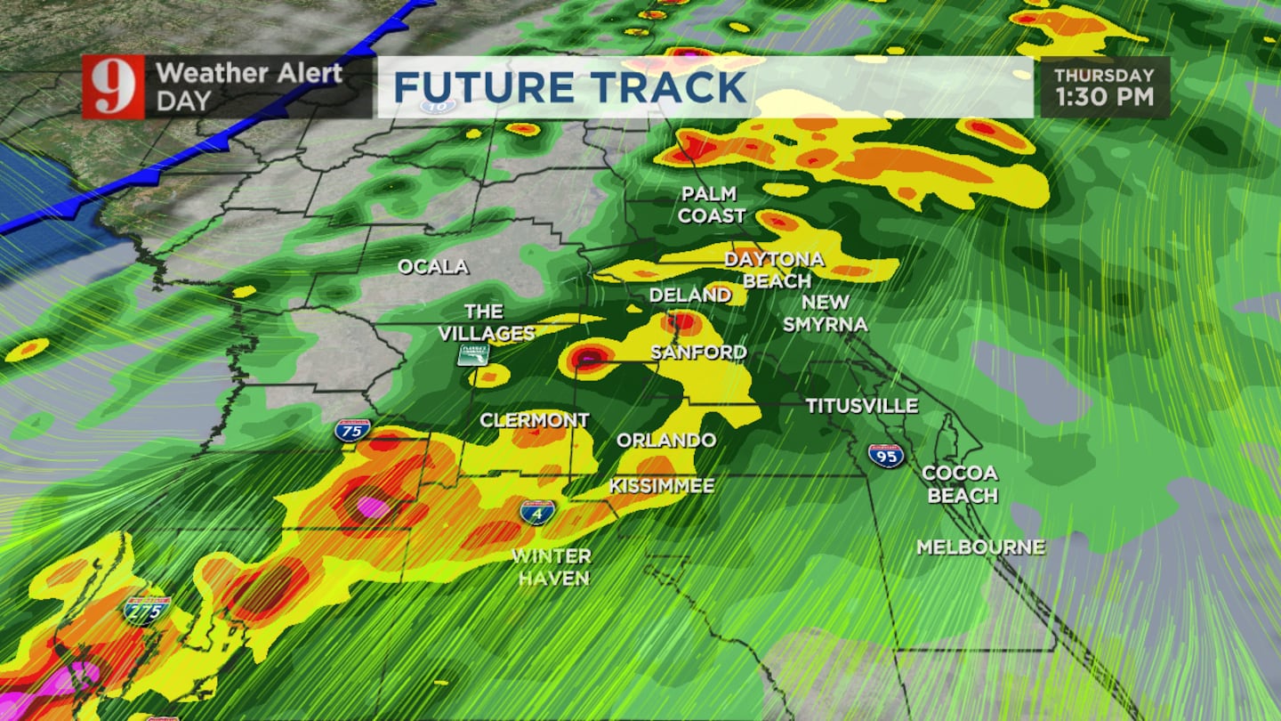
The severe weather threat will move into our southeastern areas until the evening.
Our biggest concerns with the storms will be damaging winds and an isolated tornado risk.
The cold front has already produced a damaging tornado outbreak in several Gulf states.
The highest risk for tornados in Florida will be in the panhandle overnight.
Read: 9 things every Florida homeowner should know about changes to insurance
Channel 9 meteorologists expect the storms to be weaker in our area than the damage seen in other states.
However, the 50mph wind threat and tornado threat will remain through the middle to late afternoon.
Following the storms, we will have a big cool down.
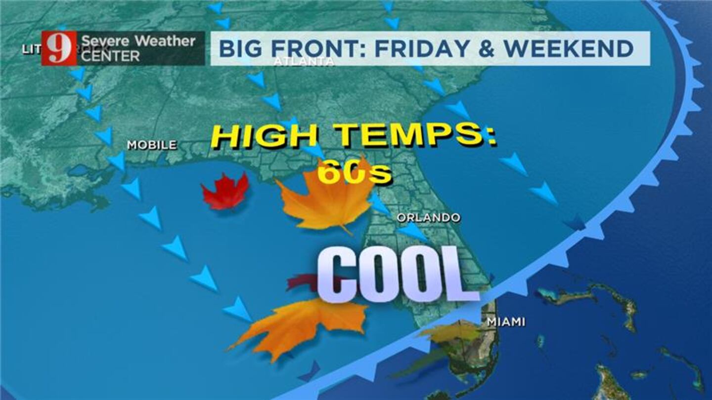
We will have high temperatures in the 60s and lows in the 40s from Friday through Sunday.
Follow our Severe Weather team on Twitter for live updates:
Visit our hurricane section: EYE ON THE TROPICS
Click here to download the free WFTV news and weather apps, click here to download the WFTV Now app for your smart TV and click here to stream Channel 9 Eyewitness News live.

©2022 Cox Media Group


