
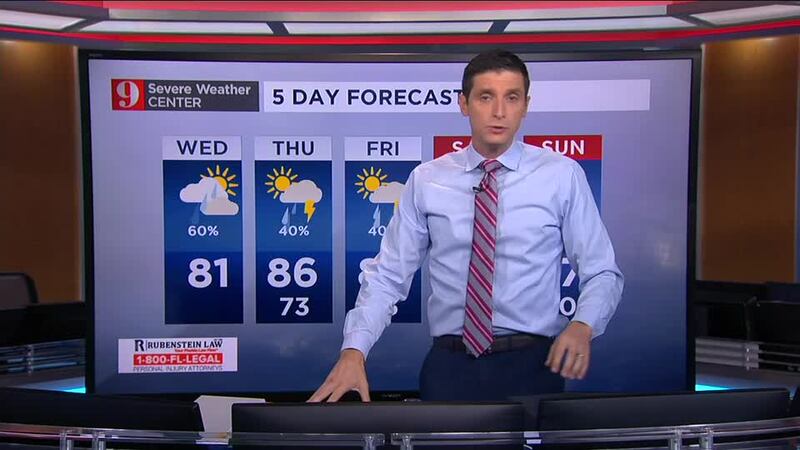
ORLANDO, Fla. — Rounds of showers and storms have moved over Central Florida, but the clouds have remained constant. This thick layer of clouds helped the maximum temperatures around the low 80s on Wednesday afternoon.
Expect mostly cloudy skies at night and lows around the low 70s across rural areas and Metro and coastal regions lows between the mid to upper 70s.
A few scattered showers are possible overnight, especially along coastal areas.
On Thursday, the winds will continue to be from the east, and there will be still plenty of moisture across Central Florida. A few breaks in the clouds, but with the chance for scattered showers and storms from morning through the afternoon hours. It won’t be a complete washout but expect similar rounds of storms to affect parts of Central Florida.
With a few breaks in the clouds, the temperatures will reach the mid-80s and humidity levels will remain high.
Slightly lower rain chance is expected on Friday.
>>> CLICK HERE TO WATCH LIVE RADAR <<<
Meanwhile in the Atlantic Hurricane Epsilon has rapidly intensified on Wednesday, and it is expected to remain east of Bermuda.
READ: Tropical Storm Epsilon strengthens into hurricane, forecast to stay in open waters
Click here to download the free WFTV weather app.
See your full five-day forecast below:
Visit our hurricane section: EYE ON THE TROPICS
Visite la sección en español: Temporada de huracanes
Follow our Severe Weather team on Twitter for live updates:
- Chief meteorologist Tom Terry
- Brian Shields
- Irene Sans
- Kassandra Crimi
- George Waldenberger
- Rusty McCranie


