Wednesday was a transitional weather day across Central Florida. Scattered storms have developed across Central Florida Wednesday afternoon, there was a cell that turned severe in Volusia County, shortly before 4 p.m. It produced a 72 mph wind gust.
The storms have come to an end. Overnight, skies will be mostly clear with a low of 71.
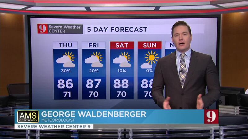
The change comes courtesy of a cold front which will be followed by a much better and nice feel to the temperatures to end the workweek. Humidity won’t be as oppressive starting Thursday and decreasing more for the weekend.
Thursday will be mostly sunny, with a very low chance for isolated storms, highs in the upper 80s. Besides the decreasing humidity, low temperatures will start to feel less warm. Saturday will feel significantly nice. Saturday morning temperatures in some places will be near the mid-60s.
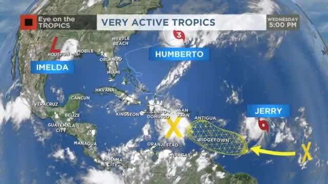
Eye on the Tropics: Humberto, Imelda, Jerry
Humberto keeps moving away from the U.S., but will impact the Bermudas Wednesday afternoon as a major Category 3 hurricane. This hurricane is still generating large swells and rough surfs along the southeastern U.S. coast from the Carolinas to Florida. The high risk for rip currents is still in places for the East Central Florida coast. Imelda continues to lose organization and will keep the rain coming for southeast Texas for the rest of the week. Since Tuesday morning, over 8 inches of rain has fallen in Galveston as it continues raining. Most of southeast Texas is under a flood watch with flood warnings being issued on and off for some areas. Areas just south of Houston have received anywhere between 2-5 inches. It will continue to rain, on and off, through Friday. The National Hurricane Center issued its last advisory for Imelda Wednesday afternoon. JERRY: CHANCE OF TROPICAL STORM FORCE WINDS IN THE CARIBBEAN
Tropical depression 10 became better organized and as forecast, it became Tropical Storm Jerry, the 10th named storm of this hurricane season, on Wednesday morning. Jerry is located about 800 miles away from the Lesser Antilles and it is moving west-northwest at 14 mph. It is expected to continue at this speed but turning more to the northwest. It could brush the top islands of the northeastern Caribbean by Friday night. But models continue to swing this system away from the Caribbean and turning more north, staying over the Atlantic, away from Florida and the rest of the U.S Atlantic coast. If everything pattern remains on track, there will be a front exiting the U.S. early next week, which will make Jerry curve before it even reaches the Bahamas and could make a dent in its organization as it will be increasing the wind shear around Jerry. Check your full five-day forecast below:
Humidity decreasing, isolated storms Thursday Weather will be much nicer this weekend
Follow our Severe Weather team on Twitter for live updates:
Cox Media Group