>>Click here to watch our 24/7 Weather stream<<
Bookmark this page to get the latest updates on the storm’s track.
BLOG EN ESPAÑOL: Isaías como tormenta tropical, trayectoria se aleja más de la costa este de Florida
See our in-depth coverage below:
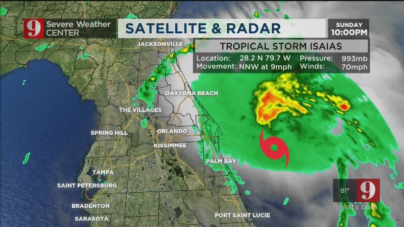
10:45 p.m. update
Isaías still crawling 55 miles east of Cape Canaveral, coastal intense conditions expected in overnight
Tropical Storm Isaias continues to move slowly at 9 mph. Located about 55 miles from Cape Canaveral, Isaías will continue to bring tropical storm gusts to coastal counties. But sustained tropical storm-force winds will remain out over sea. In fact, the strongest winds and storms will continue east of the storm, well away from Florida.
The windier conditions will persist for the next few hours before Isaías begins to move faster northward and make a slight turn north-northeast. Winds are expected to pick up over the South Carolina coast. The storm is expected to make landfall early Tuesday morning near the South Carolina-North Carolina border.
#Isaías continues to crawl to the NNW. Expect a turn to the NNE and it will finally pick up speed on Monday. Likely slamming somewhere close to the North Carolina-South Carolina border. pic.twitter.com/45UDayMTEP
— Irene Sans (@IreneSans) August 3, 2020
For Florida, some rain bands will pass through the early hours, mostly moving from northeast to southwest. By Monday, some rain and the breeze will be from west to east, ensuring fairly warm temperatures. We will return to the typical summer pattern starting on Tuesday, with the wind remaining from the west.
Click here to watch our complete coverage and see Tom Terry’s forecast at 11 p.m.
Tropical Storm #Isaias Advisory 24: Isaias Expected to Be Near Hurricane Strength When it Reaches The Carolinas. https://t.co/VqHn0u1vgc
— National Hurricane Center (@NHC_Atlantic) August 3, 2020
9:15 p.m. update
NOAA’s Hurricane Hunters share video from inside Tropical Storm Isaias
NOAA’s Hurricane Hunters shared video Sunday showing the inside of Tropical Storm Isaias.
The video also shows crews deploy an AXBT device used to help gather data from inside the storm.
Here’s video 📹 of today’s mission into TS #Isaias. Make sure to check out :37 sec & watch an AXBT deployed.
— Hurricane Hunters (@53rdWRS) August 3, 2020
✈️⛈🌪🌊#ReserveReady #ReserveResilient #ReadyAF #WeatherReady #WC130J @403rdWing @NOAA_HurrHunter @NWS @NHC_Atlantic pic.twitter.com/l2ghsb2JxN
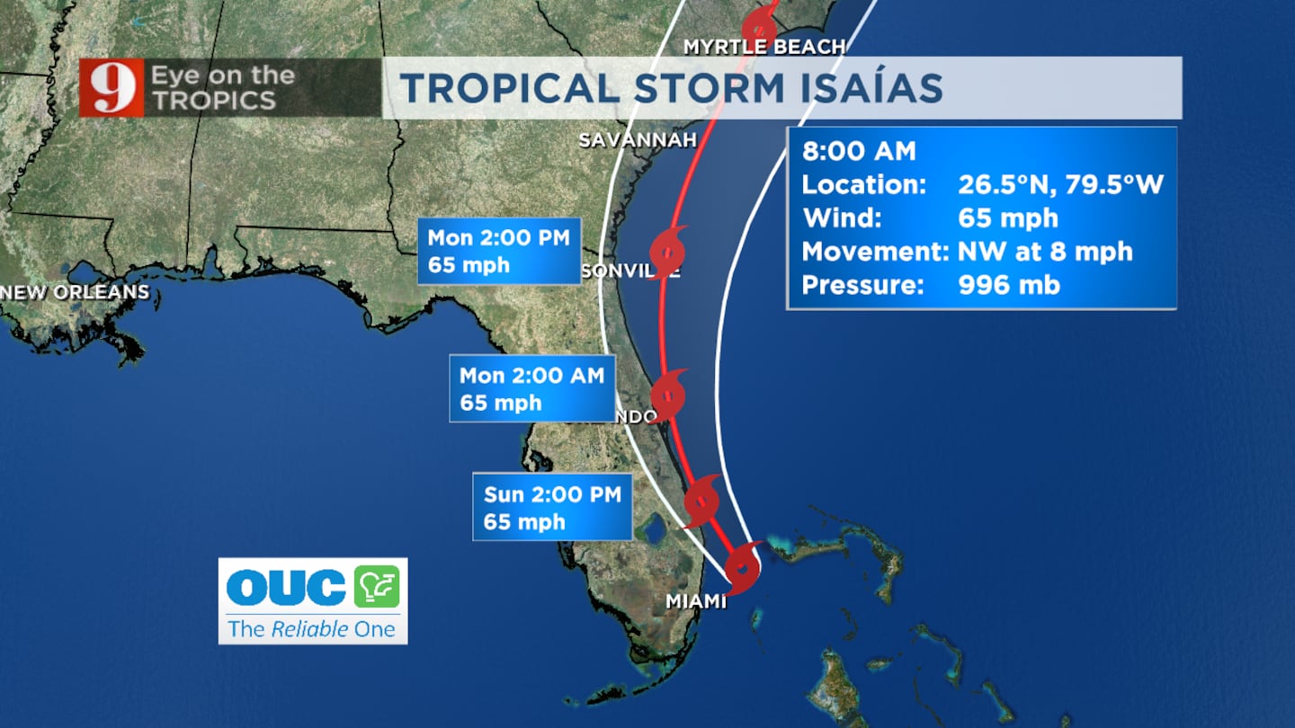
8 p.m. update
Tropical Storm Isaias continues slow crawl away from Central Florida’s coast
Tropical Storm Isaias continues to move north-northwest at 9 mph just offshore of the Central Florida coast.
Isaias still has maximum sustained winds at 70 mph, according to the National Hurricane Center.
Some coastal flooding is possible as the storm continues to track away from the state.
Stay tuned to Channel 9 Eyewitness News for the latest forecast updates.
Tropical Storm #Isaias Advisory 23A: Isaias Continues Moving North-Northwestward Just Offshore of The East-Central Florida Coast. https://t.co/VqHn0u1vgc
— National Hurricane Center (@NHC_Atlantic) August 2, 2020
Brevard County will see the strongest winds Sunday evening.
Volusia County will see their strongest winds overnight through Monday morning.
Isaias will then move farther north with a few brief passing showers possible through Monday.
Sunset to the west, tropical storm to the east. #PortCanaveral #Isaias #Florida pic.twitter.com/qQxqU9TL7C
— George Waldenberger (@GWaldenWFTV) August 3, 2020
7:15 p.m. update
Winds from Tropical Storm Isaias pick up on Central Florida’s coast
The worst of Tropical Storm Isaias is expected Sunday night and conditions are starting to worsen on the east coast of Central Florida.
Channel 9 reporter Deanna Allbrittin said winds are starting to pick up in the Indialantic and Melbourne Beach areas of Brevard County.
Wind has picked up a LOT in the past 10-15 minutes in the Indialantic/Melbourne Beach area. Hat flying off, trouble opening car doors and the hotel elevator that goes to our floor has been shut off. We will have to walk up the remaining flights for the remainder of #Isaias. pic.twitter.com/egsI14ZuXC
— Deanna Allbrittin (@deannaTVnews) August 2, 2020
Channel 9′s Volusia County reporter Mike Springer also shared video showing the winds picking up in Daytona Beach.
Winds starting to pickup along the coast in #Daytona from #Isaias pic.twitter.com/svvOz4tltz
— Mike Springer WFTV (@mspringerwftv) August 2, 2020
6:45 p.m. update
Conditions to worsen on the coast; SunRail to suspend service
Conditions are expected to worsen through Sunday evening along the coast in Brevard and Volusia counties, especially along the barrier islands, the National Weather Service said.
Elsewhere in Central Florida, SunRail said it is suspending service Monday because of Tropical Storm Isaias.
6pm| Tropical Storm Warnings have been replaced by a Wind Advisory for the Treasure Coast counties, with conditions improving this evening as Isaias continues northward.
— NWS Melbourne (@NWSMelbourne) August 2, 2020
Conditions worsening through the evening for the Space & Volusia coasts, especially along the barrier islands pic.twitter.com/jY1JQGaFwr
SunRail service will be suspended on Monday, 8/3/2020 as SunRail inspects the corridor, repairs damage and removes storm debris. pic.twitter.com/F2bF3VGGsF
— SunRail (@RideSunRail) August 1, 2020
5:15 p.m. update
Tropical Storm Isaias strengthens slightly
A slightly stronger Tropical Storm Isaias is about 40 miles offshore.
Isaias strengthened slightly while moving north-northwestward just off of Central Florida’s coast.
WATCH: Crew Dragon astronauts return to Earth after 2 months in space; see the historic splashdown
Maximum sustained winds are at 70 mph, and it’s moving north-northwest at 9 mph.
Isaias has strengthened slightly, winds to 70mph now, still a tropical storm. About to begin its pass along our Brevard Co. coastline offshore. Should take about 7-8 hours to do this. pic.twitter.com/0phXaC8wXa
— George Waldenberger (@GWaldenWFTV) August 2, 2020
It will continue this movement until Monday morning before shifting to the north-northeast.
Tropical storm force winds will extend up to 115 miles from the storm’s center, but mainly to the east of the system.
Fluctuations in intensity are expected, but overall, the system should remain a tropical storm, even when it approaches the Carolinas, where it is forecast to make landfall Tuesday.
Lifeguard stands pulled back ahead of #Isaias in New Smyrna Beach pic.twitter.com/8tIHLPvUzA
— Christopher Heath (@CHeathWFTV) August 2, 2020
For Central Florida, the forecast remains the same -- 1-foot storm surge inundation along northern Brevard and Volusia counties as well as for some inland rivers.
Isaias will skirt Central Florida’s coastline from 8 p.m. Sunday to 8 a.m. Monday.
Click here to watch Tom Terry live on Channel 9 Eyewitness News at 6, and click here to instantly download the free WFTV news and weather apps.
LIVE: Tropical UpdateIsaias now starting to move along the Brevard County coast, will stay offshore, but impacts are being felt at our beaches. Read: at.wftv.com/3gqfzx8
Posted by WFTV Channel 9 on Sunday, August 2, 2020

Winds are picking up on Cocoa Beach. We have a few people still out here walking along the shore.
— Alexa Lorenzo (@ALorenzoTV) August 2, 2020
One guy kite surfin’. @WFTV meteorologists strongly advise against that! 🪁 🌊 ❌ pic.twitter.com/CWAEqJLWFZ

3:50 p.m. update
Tropical storm winds to brush the coast Sunday evening
Tropical Storm Isaias’ winds are at 65 mph. The storm is now 50 miles from southern Brevard County and getting closer.
Parts of Central Florida’s coastline has already experienced 40 mph wind gusts.
Wind gusts picking up as #Isaias gets a little closer...one of the stronger wind gusts I've seen: 50mph at #BarefootBay. #WFTV pic.twitter.com/bRSBrAmj7H
— George Waldenberger (@GWaldenWFTV) August 2, 2020
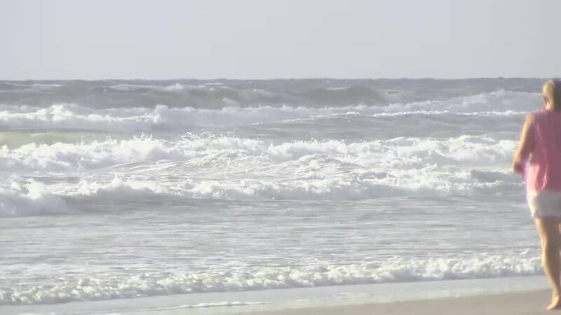
The surf is rough at beaches, and it will reach the sand dunes at high tide, which is at 8 p.m.
Beach erosion will be possible in some areas, and some coastal flooding could happen at high tide.
Isaias will likely remain a tropical storm while skirting Central Florida from 8 p.m. Sunday to 8 a.m. Monday.
Good news: Storm Surge Watch for East Central Florida coast has been cancelled.
— George Waldenberger (@GWaldenWFTV) August 2, 2020
Still: Threats exist from the rough surf, including beach erosion, flooding of low-lying coastal areas & some dock damage esp. during high tides. #WFTV #Isaias pic.twitter.com/blHv2XMsgu
The strongest winds during the period will be along the coast, which remains under a tropical storm warning.
For inland areas, including metro Orlando, waves of gusty passing showers will continue into Sunday evening.
A mass (but brief) exodus started here as the rain started coming down a bit harder as a squall moved through, with the storm offshore nearly parallel to us on the beach in Indialantic. (See next tweet) pic.twitter.com/5NZzXE0N2n
— Deanna Allbrittin (@deannaTVnews) August 2, 2020
2:45 p.m. update
Tropical Storm Isaias remains slow but strong
Tropical Storm Isaias continues to hold maximum sustained winds at 65 mph.
The latest advisory from the National Hurricane Center places the storm about 45 miles east of Vero Beach.
The storm is slowly moving to the north-northwest at 9 mph. Tropical storm force winds extend up to 115 miles from the storm’s center.
Read: What do they mean? Disturbance, depressions, tropical, subtropical storms, hurricanes
Isaias is expected to continue to move slowly until late Monday, when its speed will increase as it shifts to the north-northeast.
The storm’s strongest effects will be felt in Brevard and Volusia counties.
Storm surge inundation could top at one foot, even across some inland rivers.
Read: Tropical Storm versus Category 1 Hurricane: What’s the difference?
Tropical storm force winds are likely for southern Brevard County’s coastline, while the northern portion of the county and Volusia County should experience a bit more storm surge inundations.
Central Florida will experience intermittent rain bands throughout Sunday afternoon and Monday morning.
Outer tropical storm force wind field moving into southern Brevard county, several 40+ mph gusts reported at Sebastian Inlet. Tropical storm winds will brush the coast tonight, highest winds staying offshore. @WFTV pic.twitter.com/lD8YbBpkXq
— Tom Terry (@TTerryWFTV) August 2, 2020
Rough surf hitting #CocoaBeach, Tropical Storm Isaias 80mi. to the SSE. 8pm high tide should reach the dunes. Watching for beach erosion. pic.twitter.com/03eRDZLXCv
— George Waldenberger (@GWaldenWFTV) August 2, 2020
2PM UPDATE: Tropical Storm Isaias ~50mi. from southern Brevard County, 90mi. from Cape Canaveral. Forecast to move along yet just off our Brevard, Volusia, Flagler coast 8pm-8am. pic.twitter.com/jKqUTHULIG
— George Waldenberger (@GWaldenWFTV) August 2, 2020
1:13 p.m. update
Winds pick up in Volusia County
Reporter Jeff Levkulich spotted winds starting to pick up as a heavy rain band moved into New Smyrna Beach on Sunday afternoon.
Tropical Storm Isaias is expected to bring strong winds and storm surge in excess of 3 feet to Central Florida’s coastline Sunday.
What exactly is the difference between a tropical storm and a category 1 hurricane? Click here to find out.
#RightNow: Getting some heavy rain from a band of #Isaias in New Smyrna Beach. #WFTV #StormAlert9 pic.twitter.com/K3YKFZWr5V
— Jeff Levkulich (@jlevkulichWFTV) August 2, 2020
People out enjoying the beach #isaias pic.twitter.com/47N8MpiMq2
— Mike Springer WFTV (@mspringerwftv) August 2, 2020
Just a bit of rain and wind at #NewSmyrnaBeach! #isaias #waves #wftv pic.twitter.com/DVerNBicAT
— Kenny Gibson (@KGibsonTV9) August 2, 2020

12 p.m. update
Isaías’ track shifts farther from Florida’s east coast; here’s what to expect locally
As Tropical Storm Isaias moves along Florida’s coast, Brevard County officials have opened a storm shelter “in an abundance of caution.”
Isaias continues to be a disorganized system. Even though it tried to strengthen overnight, the wind shear and dry air has really taken a toll on this system, preventing it from intensifying back to hurricane status.
>>> CLICK HERE TO WATCH LIVE COVERAGE ON CHANNEL 9 EYEWITNESS NEWS AT NOON <<<
The 11 a.m. track from the National Hurricane Center places Isaías a bit farther east, away from Central Florida’s coastline. Had it stayed closer to the coast, there would have been more storm surge and erosion.
The coast is still expected to be battered by strong winds and up to 3 feet of storm surge.
Heavy rain bands will continue to sweep across Central Florida just like they had earlier Sunday.
Read: Volusia County recommends voluntary coastal evacuations, to open storm shelters Sunday
Expect a breezy Sunday and Monday inland as Isaias parallels the coast.
Stronger gusts and rain bands are also possible inland, bringing 1 to 3 inches of rain.
Severe Weather Center 9 will continue to monitor the situation closely, bringing you the very latest on the storm on Channel 9, wftv.com and the free WFTV news and weather apps. Click here to download them.

#Isaías has made its turn to the NNW, but it'll continue to move slowly at about 8mph until tomorrow AM when it's expected to gain speed.
— Irene Sans (@IreneSans) August 2, 2020
The latest track put the TS farther E from Florida´s east coast! Good news. Some heavy rain bands are still expected inland. pic.twitter.com/BDX3Y6PqpI
Isaias has seen a recent burst of convection but remains a tropical storm with winds of 65mph. pic.twitter.com/5dLKzulGKb
— Kassandra Crimi (@KCrimiWFTV) August 2, 2020
11 a.m. update
Isaias shifts slightly east, shows no sign of organization
Tropical Storm Isaias has shifted slightly east. The storm is showing no signs of organization.
Meteorologist Kassandra Crimi said the storm should be in Brevard County by 8 p.m. Sunday.
The coast should expect gusty winds with localized flooding at the coast.
Meteorologist Brian Shields said the worst weather is staying offshore.
10:35 a.m. update
Brevard County officials open shelter ‘in abundance of caution’ ahead of Tropical Storm Isaias
As Tropical Storm Isaias moves along Florida’s coast, Brevard County officials have opened a storm shelter “in an abundance of caution.”
Officials said the shelter will be opened at Viera Regional Community Center at 11 a.m. Sunday for county residents in need of safe harbor from potentially dangerous winds and rain conditions that could impact the area.
The shelter is located at the park at 2300 Judge Fran Jamieson Way.
The shelter will be laid out to provide for Centers For Disease Control and Prevention recommended social distancing. Health screenings, temperature checks and personal protection equipment will be in place, but those seeking shelter are also asked to bring their own PPE, such as face masks, gloves and hand sanitizer, for personal use, officials said.
The shelter will provide food but residents will need to take their own supplies, including bedding, folding chairs or sleeping bags; any needed medications; changes of clothing and sturdy shoes; personal hygiene items; and entertainment items, like games, cards, books or magazines. Officials said pets are welcome.
10 a.m. update
Osceola County Emergency Management offers advice for residents ahead of Tropical Storm Isaias
Osceola County Emergency Management officials are urging residents to stay alert regarding Tropical Storm Isaias.
They said residents of the eastside of the county, from Holopaw and Harmony south to Kenansville and Yeehaw Junction, may experience winds of 39 to 57 mph and receive 1 to 2 inches of rain. They said wind gusts at times may be higher, and rain may lead to localized flooding in some areas.
Residents on the east side of @OsceolaCountyFl, from Holopaw and Harmony south to Kenansville and Yeehaw Junction, may experience winds of 39-57 mph and receive 1-2" of rain. Wind gusts at times may be higher, and rain may lead to localized flooding in some areas.
— OsceolaEOC (@OsceolaEOC) August 2, 2020
After the storm, tree limbs may be taken to the following locations:
— OsceolaEOC (@OsceolaEOC) August 2, 2020
➡️ Kissimmee
Bass Road Yard Waste Site 407-742-7780.
➡️ St. Cloud
2701 Peghorn Way 407-957-7289.
➡️ St. Cloud/Holopaw: Call the JED landfill at 407-891-3720 to determine if yard waste is accepted.
Please continue to monitor weather updates, and be sure to secure loose items around your home, including trash and recycling containers or any items left at the curb for pickup until after the storm has passed.
— OsceolaEOC (@OsceolaEOC) August 2, 2020
9:15 a.m. update
Squalls from Tropical Storm Isaias moving into Central Florida
Channel 9 meteorologist Kassandra Crimi said squalls from Tropical Storm Isaias are moving into Central Florida Sunday morning.
She said the storm remains 30 miles off the coast of South Florida.
Squally weather and quick moving showers move onshore. TS Isaias remains just over 30miles off the coast of South Florida. pic.twitter.com/MwiOEcA95M
— Kassandra Crimi (@KCrimiWFTV) August 2, 2020
READ: Power outages: What you need to know when the power goes out
8:50 a.m. update
New track shows Tropical Storm Isaias slowing as it skirts Florida’s east coast
Channel 9 meteorologist Kassandra Crimi said the 8 a.m. advisory for Tropical Storm Isaias shows the track of the storm continuing to skirt the east coast of Florida.
She said the new track keeps the storm at tropical storm strength with winds of 65 mph.
The storm is moving even slower as of the 8 a.m. update, inching northwest up the coast at 8 mph. It is set to be off the coast of Central Florida very early Monday morning.
Stay tuned to Channel 9 Eyewitness News for the latest forecast updates.

8:40 a.m. update
Center of Tropical Storm Isaias off the coast of Palm Beach County, outer bands moving into Volusia, Brevard
The National Weather Service said the center of Tropical Storm Isaias is now off the coast of Palm Beach County. Officials said outer bands are moving into Volusia and Brevard counties.
8:15am | A glance at the radar shows the center of #Isaias is now off the coast of Palm Beach County.
— NWS Melbourne (@NWSMelbourne) August 2, 2020
In ECFL, outer bands are moving onshore into Volusia and northern Brevard counties. Brief moderate to heavy downpours and wind gusts up to 50 mph will be possible through 11am. pic.twitter.com/IhUGmUdKyl
Channel 9 reporter Megan Cruz said she sought shelter under an awning as a squall moved in to Cocoa Beach.
Joining some other folks under an awning to avoid another squall! #isaias #florida #WFTV #HurricaneSeason @WFTV #Brevard #cocoabeach pic.twitter.com/IXuhUgsCKA
— Megan Cruz (@MeganWFTV) August 2, 2020
7:50 a.m. update
‘Life-threatening surf’ possible as Tropical Storm Isaias moves north along Florida’s coast
Channel 9 meteorologist Brian Shields said life-threatening surf conditions are possible as Tropical Storm Isaias continues to move north along Florida’s east coast.
“Stay out of the water,” he said.
Coastal flooding/overwash possible today & tonight. Life-threatening surf. Stay out of the water.
— Brian Shields (@BrianWFTV) August 2, 2020
7:15 a.m. update
Brief showers move in to Cocoa Beach
Channel 9 reporter Megan Cruz is in tracking Tropical Storm Isaias’ impact in Cocoa Beach.
She reported that a brief shower rolled through just after sunrise, quickly drying up. She said the ocean is rough, and it’s a bit breezy, but otherwise a nice morning there so far.
Channel 9 Meteorologist Kassandra Crimi is warning people to stay out of the surf as the storm is forecast to cause dangerous conditions in the water, with 5 to 8 foot waves this morning, getting even higher this afternoon.
And just like that... dry again ☺️Listening to @BrianWFTV and @KCrimiWFTV in the background for the very latest updates 👍🏼 #isaias #Florida #weather #WFTV @WFTV pic.twitter.com/y5DANbtfe8
— Megan Cruz (@MeganWFTV) August 2, 2020
It’s a GOOD morning from Cocoa Beach because #Isaias is weakening! Windy with some rough surf, but that’s it. @WFTV #WFTV #florida #weather pic.twitter.com/JGzSDqcDnq
— Megan Cruz (@MeganWFTV) August 2, 2020
6:25 a.m. update
Brevard County prepares for possible storm surge flooding
Brevard County Emergency Management officials said Tropical Storm Isaias could produce 2 to 4 foot storm surge flooding along portions of the coast.
8/2/20 6:20AM | Tropical Storm #Isaias could produce 2-4 feet of storm surge flooding along portions of Florida east coast. Visit https://t.co/oT3efCiMEY for more details and https://t.co/mzloMMCNmO for your local weather forecast. pic.twitter.com/DFEI7aXCXp
— Brevard EOC (@BrevardEOC) August 2, 2020
Cool. A little breezy along the coast. But overall, nice conditions this morning #Isaias pic.twitter.com/E9RNNs08mZ
— Mike Springer WFTV (@mspringerwftv) August 2, 2020
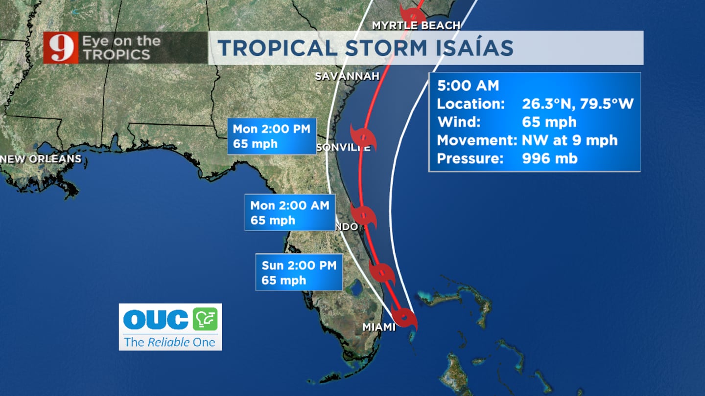
5:40 a.m. update
Tropical storm warnings in place for east Central Florida ahead of Tropical Storm Isaias
Tropical storm warnings are in place for all of east Central Florida except for Lake County, according to the National Weather Service.
Aug 2, 5AM | Tropical Storm Warnings in place for all of east-central FL, except for Lake County. Passing squalls will produce gusts up to 75 mph along the coast & 45-55 mph inland.
— NWS Melbourne (@NWSMelbourne) August 2, 2020
Travel on barrier islands will become hazardous as winds increase and squalls move through. pic.twitter.com/D9aWTJOdLv
There are NO hurricane watches or warnings for Central Florida. I just don't see issues inland. Watching the immediate coast for some flooding/overwash. Worst weather stays offshore. Live on 9.
— Brian Shields (@BrianWFTV) August 2, 2020
5:10 a.m. update:
Tropical Storm Isaias weakens, worst weather on track to stay off Florida’s east coast
Tropical Storm Isaias is continuing to weaken, according to the 5 a.m. track, now with max winds of 65 mph.
Channel 9 meteorologist Brian Shields said the latest track is good news for Florida as it keeps the worst of the storm’s weather off the east coast of the state.
Shields said the storm is not expected to strengthen back into a hurricane.
“Overall this is better news,” he said.
Meteorologist Kassandra Crimi said the storm’s continued weakening means the hurricane watches and warnings have been dropped from our coastal areas.
She said there will still be dangerous conditions in the water, with 5 to 8 foot waves this morning, getting even higher this afternoon.
Stay tuned to Channel 9 Eyewitness News for the latest forecast updates.
SUNDAY UPDATE: Good News Continues... Isaias continues its weakening trend. The worst weather will stay...
Posted by Brian Shields, WFTV on Sunday, August 2, 2020
4:15 a.m. update:
Tropical Storm Isaias continues slow track towards Florida’s east coast
Tropical Storm Isaias remains a tropical storm early this morning with maximum sustained winds of 70 mph.
Isaias will move back over warm waters through the morning, where some intensification could occur.
Isaias is expected to either remain a high-grade Tropical Storm or intensity to a low-grade Category 1 Hurricane, sliding up our east coast throughout the day.
Near-hurricane force winds remain possible along our coast, with a maximum peak storm surge of 2-4 feet.
Coastal erosion and coastal flooding are concerns.
Timing of Isaias’ impacts are expected Sunday afternoon through Monday morning.
Channel 9 meteorologist Brian Shields will bring you the latest updates on the storm beginning at 5 a.m. on Channel 9 Eyewitness News.
New 11pm track update...Isaias still a tropical storm, winds at 70mph. Forecast to intensify slightly, enough to achieve hurricane status before passing along our coast tomorrow later in the day. #WFTV pic.twitter.com/a6Zda40BX5
— George Waldenberger (@GWaldenWFTV) August 2, 2020

Cox Media Group


