Tropical Storm Karen will be slowing down well north of Puerto Rico and meander in this same vicinity for four days through the weekend.
ORLANDO, Fla. — During this time, the already well-disorganized storm will struggle to become organized and wind shear could put an end to this system,
dissipating it.
It is becoming more apparent that Karen will not be a threat to Florida or the U.S., at least as a tropical system.
Karen's center has become even broader and it continues to become messier. Still, some rain showers associated with the system are affecting the northeastern Caribbean.
Rain totals have been between 2 to 4 inches with up to 8 inches in some isolated spots across Puerto Rico and the Virgin Islands.
We will continue to monitor this and bring you the latest on Eyewitness News, wftv.com and on our free WFTV Weather app.
HURRICANE LORENZO
Lorenzo became the 5th hurricane of the 2019 Atlantic Hurricane Season. It is forecast to continue intensifying and likely become a major hurricane by Thursday. The good news is that Lorenzo will stay over the eastern Atlantic without affecting any land.
POST-TROPICAL CYCLONE JERRY
Jerry has weakened and it is not a post-tropical cyclone, meaning it has lost its tropical characteristics. It will continue to weaken and come just north of Bermudas in the next 24 hours.
WEEKLY FORECAST
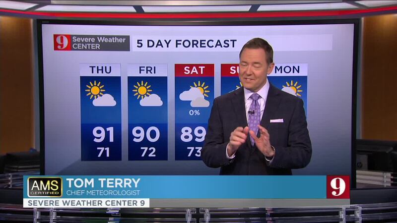
This week's forecast calls for a dry weather pattern with highs near 90 and nearly no chances for rain. Wednesday's forecast calls for slightly warmer temperatures with a high of 92 and mostly sunny skies.
The winds will be a bit stronger during on Thursday through Saturday, from the east.
Humidity will slowly start to increase and it will start to feel muggier each day. By Sunday, there could be some isolated showers across Central Florida.
Catch up on your full five-day forecast below:
Follow our Severe Weather team on Twitter for live updates:
- Chief meteorologist Tom Terry
- Brian Shields
- Irene Sans
- Kassandra Crimi
- George Waldenberger
- Rusty McCranie

Cox Media Group


