ORLANDO, Fla. — Tropical Storm Laura is moving toward the Gulf of Mexico. The storm is expected to strengthen into a Category 2 hurricane Wednesday.
11 p.m. update:
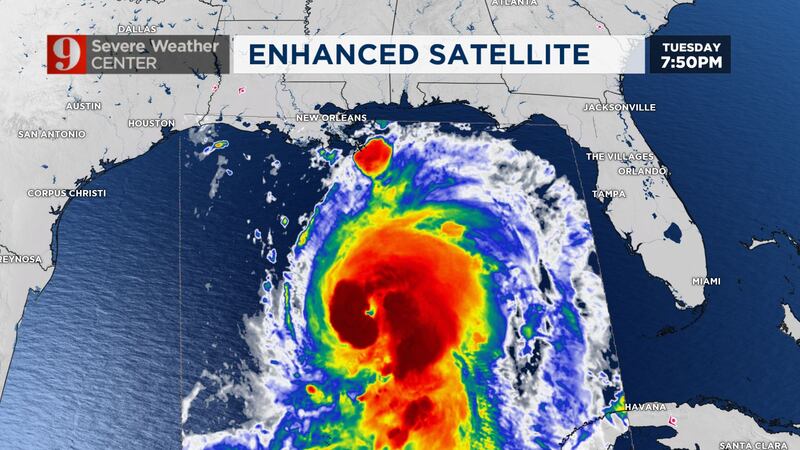
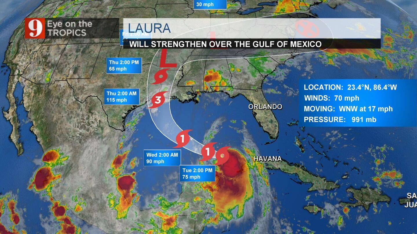
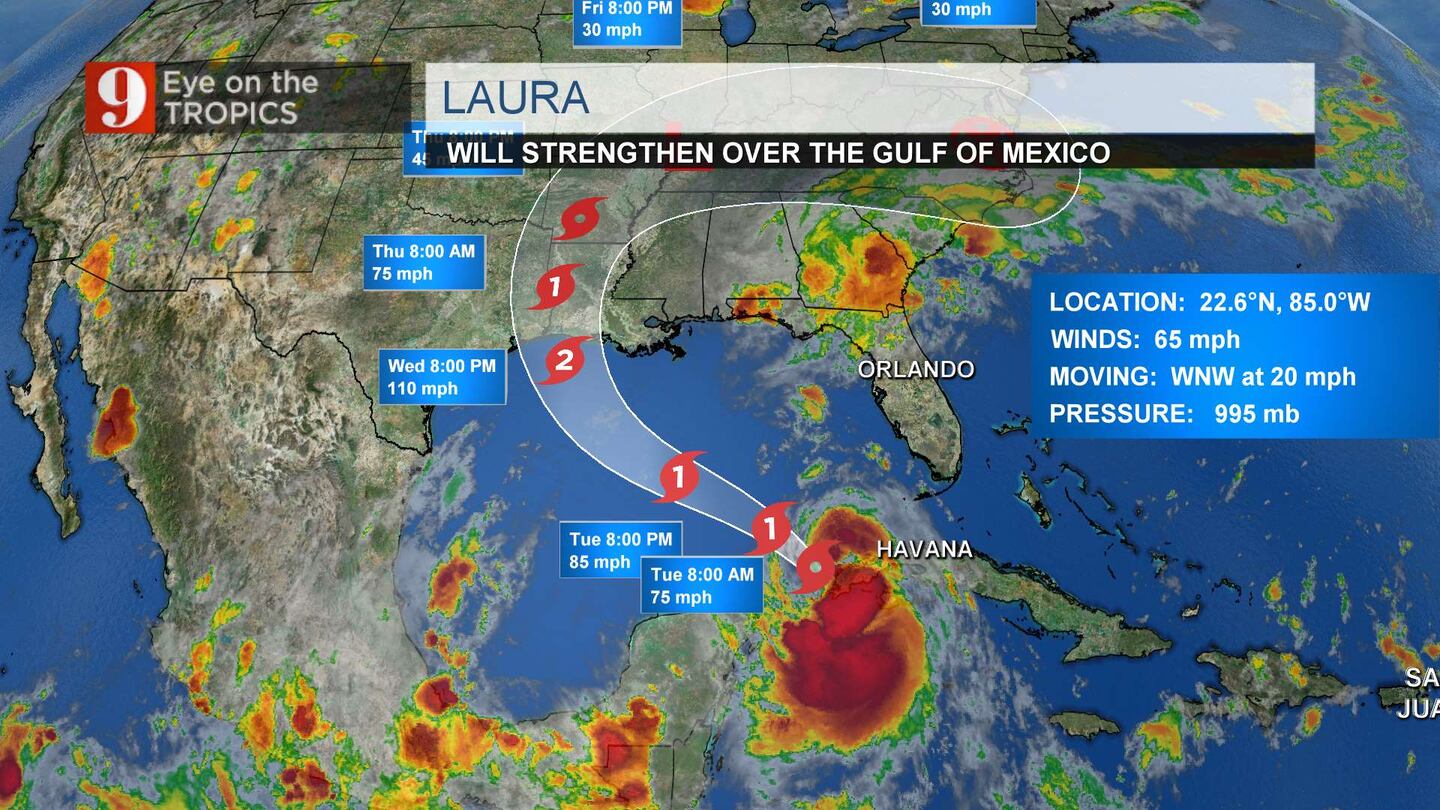
Hurricane Laura is still churning in the Gulf on Tuesday night, gaining steam as it moves closer to making landfall.
Laura’s winds have increased from 85 mph to maximum sustained winds at around 90 mph.
11pm #Laura. Winds up to 90mph, pressure dropping fast, and a big MAJOR hurricane on the way to SE TX and SW LA. #EyeonTropics pic.twitter.com/FKuN9hyVUL
— Tom Terry (@TTerryWFTV) August 26, 2020
Laura is moving west-northwest at 17 mph.
Hurricane #Laura continues to strengthen over the Gulf of Mexico and it is expected to be a major hurricane at landfall. Here are the 10 pm CDT Key Messages. See https://t.co/tW4KeFW0gB for details. pic.twitter.com/98iYi8FR2P
— National Hurricane Center (@NHC_Atlantic) August 26, 2020

8 p.m. update:
Hurricane Laura continues to strengthen in the Gulf of Mexico as its maximum sustained winds reach 85 mph.
The National Hurricane Center reported Laura is expected to become a Category 2 storm Wednesday morning.
Hurricane Laura strengthens a bit further, winds up to 85 mph, more intensification expected tonight. pic.twitter.com/rmuvL77jne
— George Waldenberger (@GWaldenWFTV) August 25, 2020
Laura is moving west-northwest at 17 mph and is not projected to impact Central Florida.
Laura is forecast to be a major hurricane as it makes landfall near the border of Texas and Louisiana early Thursday.
Hurricane #Laura Advisory 24A: Laura Strengthening Over the Central Gulf of Mexico. https://t.co/VqHn0u1vgc
— National Hurricane Center (@NHC_Atlantic) August 25, 2020
5 p.m. update:
Laura’s track toward the southwestern part of Louisiana still unchanged but the National Hurricane Center highlights that it is still possible for the hurricane to make landfall over southeastern Texas.
Hurricane Laura should take a slight turn to the west-northwest this evening then a northwest turn to the northwest overnight and then to the north on Wednesday evening into Thursday morning as it makes landfall.
Keep in mind that impacts specifics will shift if the track shifts.
#LAURA 5p: Deepest water to occur along the immediate coast near & to the right of the landfall location + large & destructive waves. Storm surge could penetrate up to 30miles inland from the coast in SW #Louisiana and far SE #Texas
— Irene Sans (@IreneSans) August 25, 2020
More here: https://t.co/MJbnQQUwNV pic.twitter.com/tdnQJHrx4d
Hurricane Laura will continue to intensify as it moves over warm Gulf waters and could reach its highest strength just before making landfall late Wednesday or early Thursday morning.
This will be a catastrophic storm and poses many risks, even if for residents well inland.
See impacts below at the 1p.m. update:
— Who is That Masked Man? (@DisasterPIO) August 25, 2020
3 p.m. update:
Evacuation orders in place for parts of Texas and Louisiana.
The emergency alert system here east of Houston has triggered at least three times in the past 30 minutes. Good to see increased awareness of growing threat. pic.twitter.com/Yx0dYVZ83C
— Matthew Cappucci (@MatthewCappucci) August 25, 2020
1 p.m. update:
IMPACTS TO GULF COAST
Storm Surge: Up to 9 feet of storm surge inundation is possible along the immediate coast of Louisiana and eastern texas.
Rain: From Wednesday night into Saturday, Laura is expected to produce rainfall of 4 to 8 inches, with isolated maximum amounts of 12 inches across portions of the west-central U.S. Gulf Coast from western Louisiana into east Texas, and northward into portions of the lower to middle Mississippi Valley, lower Ohio Valley, and Tennessee Valley. This rainfall will cause widespread flash and urban flooding, small streams to overflow their banks, and minor to isolated moderate river flooding.
Wind: A category 3 or 4 hurricane could cause power outages for weeks. Expect major damage from Laura.
WHEN WILL IT MAKE LANDFALL?
Hurricane Laura will likely make landfall late Wednesday evening somewhere from eastern Texas to the central Louisiana coast. There are some models still calling for track shifts until landfall. Also, conditions are favorable for this system to rapidly intensify to category 3 hurricane status by Tuesday evening and there is a chance it could reach category 4 on Wednesday.
We will continue to monitor closely and bring you the latest on our newscasts, wftv.com and on our free WFTV weather app.
11 a.m. update:
The National Hurricane Center released the 11 a.m. Hurricane Laura complete advisory and surprisingly there were no major changes to the track of intensity since their special 8:15 a.m. statement.
NEW WATCHES AND WARNINGS IN EFFECT FOR GULF COAST REGIONS
Hurricane Laura is still holding 75 mph maximum sustained winds and is moving west-northwest at 16 mph. New hurricane warnings were issued for coastal parts of Southeast Texas from San Luis Pass to Intracoastal City in Louisiana.
At least 111 mph winds at landfall. Dry air + warm waters=battle intensify, will make the center wobble as Laura moves over the Gulf of Mexico. Southeastern #Texas be ready for a major category hurricane. pic.twitter.com/upVmBoAf9t
— Irene Sans (@IreneSans) August 25, 2020
Storm surge watches and warnings are also in effect from Texas to the mouth of the Mississippi River.
As Hurricane Laura continues to track over the warm waters of the Gulf of Mexico growing and intensifying, the system’s eye could wobble a bit, wobbling would mean that there could still be slight shifts in the track. Being so close to a metropolitan city is very worrisome. Houston is already in the cone and the same southeastern portion of Texas was battered by Hurricane Harvey in 2017. Drainage issues, bayous, rivers, and overpopulation could be in danger again by the heavy rains. This system is not compared to Harvey as it will be moving and it is not expected to remain parked, but we are still talking about a major category hurricane.
Read: What do they mean? Disturbance, depressions, tropical, subtropical storms, hurricanes
8:30 a.m. update:
Laura has intensified and it is now a hurricane with 75 mph winds, according to the National Hurricane Center.
Hurricane hunters were investigating the storm and found maximum sustained winds of 75 mph with higher gusts.
Here is the special update from the NHC on Laura making hurricance status. Winds are 75mph, pressure down to 991mb. Laura is a rapidly strenghening, deepening storm. pic.twitter.com/gt4veM57Hx
— Rusty McCranie (@RMcCranieWFTV) August 25, 2020
8 a.m. update:
Hurricane hunters said that Tropical Storm Laura’s maximum sustained winds have increased to 70 mph.
The National Hurricane Center said Laura is continuing to move away from Cuba and it is expected to move toward the southeastern Gulf of Mexico Tuesday morning.
The storm is expected to become a hurricane later this afternoon.
Laura is moving west-northwest at 17 mph.
See the 8 a.m. track below:
5 a.m. update:
The National Hurricane Center said Tropical Storm Laura is expected to become a major hurricane as it approaches the Louisiana/Texas coast.
Forecasters expect Laura to become a category 3 storm when it makes landfall early Thursday morning. They said significant strengthening is forecast during the next 48 hours.
The storm is moving west northwest at 17 mph with 65 mph winds.
Laura will move away from Cuba and over the southeastern Gulf of Mexico Tuesday morning, the National Hurricane Center said.
5am Tuesday update: The center of TS Laura has emerged north of Cuba this morning. Laura is expected to become a hurricane later today and a major category 3 hurricane before landfall Thursday morning along the E Texas/W Louisiana coastline. pic.twitter.com/mOQc8nKGVV
— Rusty McCranie (@RMcCranieWFTV) August 25, 2020
Read: Let us explain: What is the ‘dirty side’ of a tropical system
4:30 a.m. update:
The National Hurricane Center said Laura is forecast to turn toward the northwest by Wednesday and should continue to move northwestward through Wednesday night.
It will move away from Cuba and over the southeastern Gulf of Mexico Tuesday morning and approach the coasts of Texas and Louisiana Wednesday night.
Laura’s maximum winds are near 65 mph. The National Hurricane Center said Laura could be near major hurricane strength when it approaches the coast Wednesday night.
See 2 a.m. track below:
Cox Media Group


