:quality(70)/arc-anglerfish-arc2-prod-cmg.s3.amazonaws.com/public/OPO5QQUO7JJLFL5V26IVVSGKRE.jpg)
ORLANDO, Fla. — Conditions will be more enjoyable and drier as Central Florida sees a break from widespread afternoon storms.
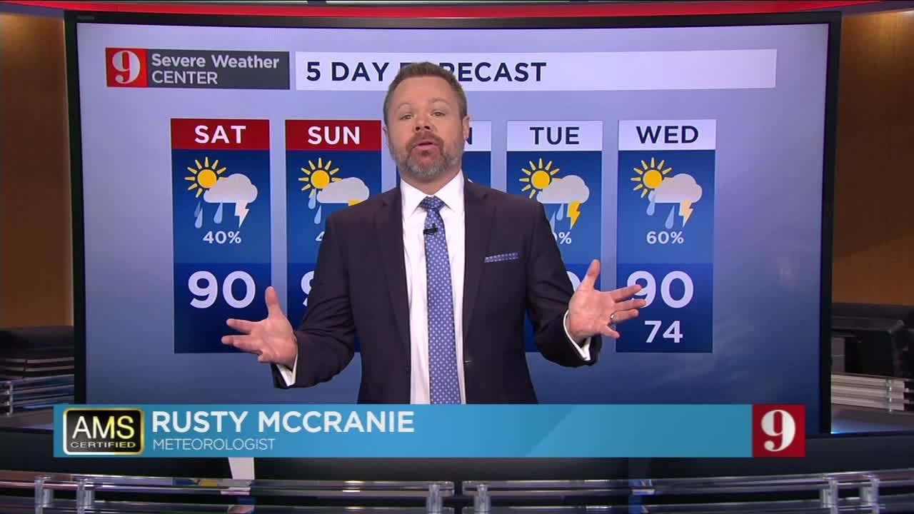
Rain is expected Saturday afternoon but the chances for rain will be much lower across Central Florida.
Download the WFTV weather app | Hour-by-hour in your city
The best chance for rain will be a few spotty showers along the east coast, back toward metro Orlando.
Most of rain will be in the northeastern region of Florida, with Central Florida only seeing some scattered pop-up showers in the afternoon.
Watch Live: Doppler 9 HD | Live updates on Eyewitness News
Temperatures will be fairly comfortable for late July, with highs mainly in the mid-to upper 80s.
Expect Sunday to be similar to Saturday before rain chances come back by the workweek.
Eye on the Tropics
The hurricane season is well upon us, but no tropical development is expected over the next five days.
The rain is on the way to Daytona Beach... pic.twitter.com/UWU4MT5JY0
— Rusty McCranie (@RMcCranieWFTV) July 27, 2019
Although Central Florida will be much drier overall today, showers have already developed in portions of coastal Volusia and Flagler counties.
— Rusty McCranie (@RMcCranieWFTV) July 27, 2019
These showers are moving south right down I-95. pic.twitter.com/PrSRcWVUij
Catch up on your full five-day forecast below:
Follow our Severe Weather team on Twitter for live updates:
- Chief meteorologist Tom Terry
- Brian Shields
- Irene Sans
- Kassandra Crimi
- George Waldenberger
- Rusty McCranie
:quality(70)/mediaweb.wftv.com/photo/2018/11/08/APP%20DOWNLOAD%20WEX_1541693886850.jpg_13622063_ver1.0.jpg)
Cox Media Group
:quality(70)/cloudfront-us-east-1.images.arcpublishing.com/cmg/HMWCPQ3BJ5GIHGSZSPR7M5ELQ4.jpeg)
:quality(70)/cloudfront-us-east-1.images.arcpublishing.com/cmg/IJMIFE2ICBAUBIN43BQCUVHU7Y.jpg)
:quality(70)/cloudfront-us-east-1.images.arcpublishing.com/cmg/G7GT3ELJ7JFKNMVGJVBUUOTNGU.jpg)
:quality(70)/cloudfront-us-east-1.images.arcpublishing.com/cmg/BWAG42EMMNDIHKNOJAK5BB3GVU.jpg)
:quality(70)/cloudfront-us-east-1.images.arcpublishing.com/cmg/SBOVJLPSO5GYFBWXZUZX6D7IMA.jpeg)