
ORLANDO, Fla. — The beginning of the workweek began warm and a bit more humid across Central Florida. Monday afternoon’s highs hit 82 degrees in Orlando and Titusville, Daytona Beach hit 80 degrees.
The evening will stay partly cloudy with patchy fog developing again overnight. Lows will drop to the low to mid-60s.
This strong front is bringing 25+ temperature drop for the Central US... but #Florida, we will not participate in the fun.
— Irene Sans (@IreneSans) December 9, 2019
It will lose strength, become stationary, upping our rain chances this week. #stormalert9
Read/watch forecast here: https://t.co/DuWUoBx3v0 pic.twitter.com/uwVvOVGbWh
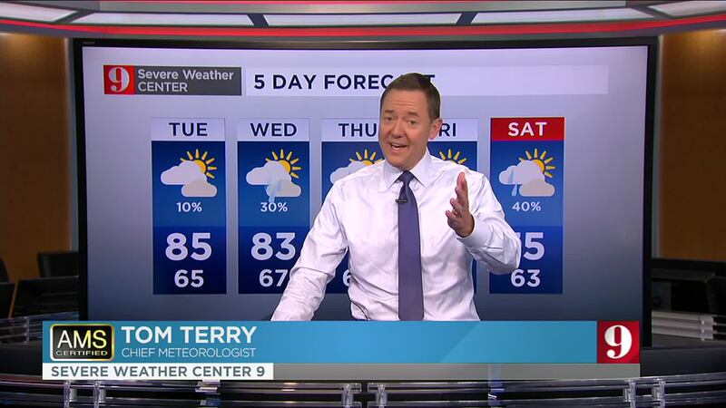
A near-record warmth is expected for Tuesday, with temperatures in the afternoon in the mid-80s area-wide.
A cold front is forecast to cross Central Florida by Wednesday. Temperatures are not expected to drop a lot, but the front will bring scattered showers that could stick around until the end of the week. Rain probabilities are highest on Thursday, about 60 percent of Central Florida will receive measurable rain. The day will remain mostly cloudy and temperatures will be closer to the average for this time of the year
Catch up on your full 5-day forecast:
Watch your daily weather forecast from digital meteorologist Irene Sans:


Más información en español aquí: El tiempo para Florida Central
Follow our Severe Weather team on Twitter for live updates:
- Chief meteorologist Tom Terry
- Brian Shields
- Irene Sans
- Kassandra Crimi
- George Waldenberger
- Rusty McCranie

DOWNLOAD: Free WFTV News & Weather Apps
Cox Media Group


