Monday’s clouds and passing showers are just the beginning of a wet week ahead.
Channel 9′s team of meteorologists are monitoring a front draped over South Florida, extending west to a low pressure area over the western Gulf of Mexico.
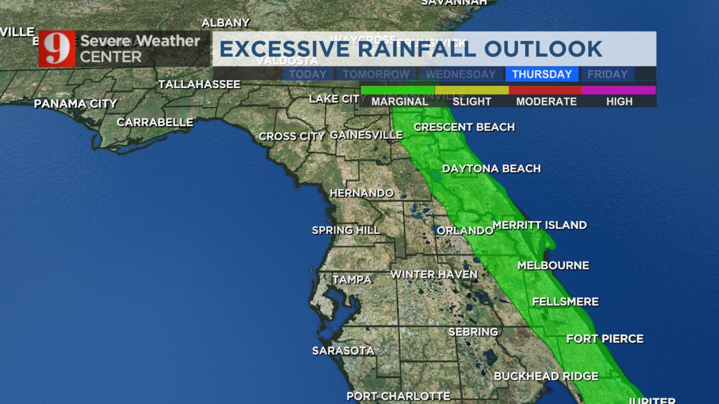
“It’ll take a few days, but the Gulf Low will approach Florida, and then make a sort of hopscotch over the state,” certified meteorologist George Waldenberger said. “The result: more scattered rain Tuesday and thunderstorms Wednesday evening, overnight and Thursday.”
Heavy rain will be the greatest threat to Central Florida.
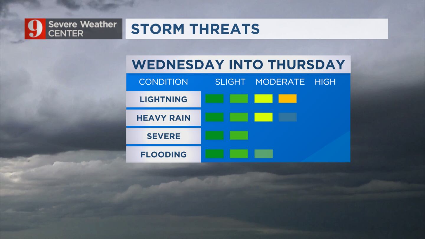
Storm threats (WFTV)
Meanwhile, in the tropics, a separate system over the Caribbean is showing higher potential to develop into a tropical depression or named storm later this week.
The next name would be “Vince.”
“But flow pattern would keep this system well southeast of Florida,” Waldenberger said.
Click here to download our free news, weather and smart TV apps. And click here to stream Channel 9 Eyewitness News live.
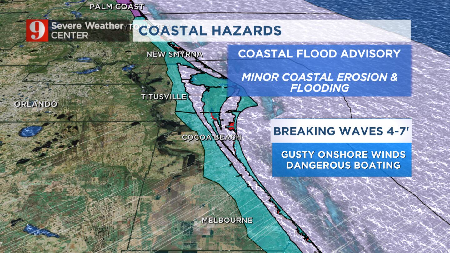
Coastal hazards (WFTV)
0 of 55
New Smyrna Beach to share recovery plan on storm damage, beach erosion from Hurricane Nicole
New Smyrna Beach to share recovery plan on storm damage, beach erosion from Hurricane Nicole
Erosion reveals structure on beach Erosion from Hurricane Nicole revealed a mysterious structure on the beach in Volusia County. (Volusia Beaches)
New Smyrna Beach to share recovery plan on storm damage, beach erosion from Hurricane Nicole
New Smyrna Beach to share recovery plan on storm damage, beach erosion from Hurricane Nicole
New Smyrna Beach to share recovery plan on storm damage, beach erosion from Hurricane Nicole
New Smyrna Beach to share recovery plan on storm damage, beach erosion from Hurricane Nicole
Hurricane Nicole dune repairs
Sunglow Resort Condo hurricane damage
NOVEMBER 10 In this aerial view, flood water surround a building after Hurricane Nicole came ashore on November10, 2022 in Daytona Beach, Florida. Nicole came ashore as a Category 1 hurricane before hitting Florida’s east coast. (Joe Raedle/Getty Images)
NOVEMBER 10 Lisa Lavigna takes pictures of her mother Nina Lavigna's home after it partially toppled onto the beach as Hurricane Nicole came ashore on November 10, 2022 in Daytona Beach, Florida. Nicole came ashore as a Category 1 hurricane before weakening to a tropical storm as it moved across the state. (Joe Raedle/Getty Images)
NOVEMBER 10 Brooke Voegtle walks through flood water that inundated streets after Hurricane Nicole came ashore on November10, 2022 in Daytona Beach, Florida. Nicole came ashore as a Category 1 hurricane before hitting Florida’s east coast. (Joe Raedle/Getty Images)
Large amounts of sand washes up on Flagler County beach after Hurricane Nicole Flagler County estimates that Nicole will cost it a total of $23.7 million in damage. (Flagler County Emergency Management /Flagler County Emergency Management)
See damage left behind by Tropical Storm Nicole in Central Florida Hurricane Nicole has impacted many counties across Central Florida, especially those along the coast.
Volusia County hurricane damage Volusia County hurricane damage (wftv.com)
Tropical Storm Nicole Bears Down On Florida's Atlantic Coast DAYTONA BEACH, FLORIDA - NOVEMBER 10: Homes are partially toppled onto the beach after Hurricane Nicole came ashore on November10, 2022 in Daytona Beach, Florida. Nicole came ashore as a Category 1 hurricane before weakening to a tropical storm as it moved across the state. (Photo by Joe Raedle/Getty Images)
Photos: Tropical Storm Nicole leaves Florida peninsula drenched, damaged Dale laJeunesse speaks to a member of Daytona Beach Fire Rescue as he stands in front of his home, which is surrounded by floodwaters, after Hurricane Nicole came ashore on November 10, 2022, in Daytona Beach, Florida. Nicole came ashore as a Category 1 hurricane before weakening to a tropical storm as it moved across the state. (Joe Raedle/Getty Images)
Photos: Tropical Storm Nicole leaves Florida peninsula drenched, damaged In this aerial view, seawalls along condo buildings are shown breached by Hurricane Nicole on November 10, 2022, in Daytona Beach, Florida. The storm surge associated with Nicole coincided with already-high tides caused by this week's full moon, putting more stress on aging sea walls meant to protect coastal communities. (Joe Raedle/Getty Images)
Photos: Tropical Storm Nicole leaves Florida peninsula drenched, damaged People look on at homes that are partially toppled onto the beach after Hurricane Nicole came ashore on November10, 2022, in Daytona Beach, Florida. Nicole came ashore as a Category 1 hurricane before weakening to a tropical storm as it moved across the state. (Joe Raedle/Getty Images)
Photos: Tropical Storm Nicole leaves Florida peninsula drenched, damaged Danny Sonn (left) and Warren Hoganson (right) help homeowner Nina Lavigna salvage what she can from her home after it toppled onto the beach as Hurricane Nicole came ashore on November 10, 2022, in Daytona Beach, Florida. Nicole came ashore as a Category 1 hurricane before weakening to a tropical storm as it moved across the state. (Joe Raedle/Getty Images)
Photos: Tropical Storm Nicole leaves Florida peninsula drenched, damaged In this aerial view, seawalls along condo buildings are shown breached by Hurricane Nicole on November 10, 2022, in Daytona Beach, Florida. The storm surge associated with Nicole coincided with already-high tides caused by this week's full moon, putting more stress on aging sea walls meant to protect coastal communities. (Joe Raedle/Getty Images)
Photos: Tropical Storm Nicole leaves Florida peninsula drenched, damaged Members of the Daytona Beach Fire Department walk through floodwaters searching for people that may need help after Hurricane Nicole came ashore on November 10, 2022, in Daytona Beach, Florida. Nicole came ashore as a Category 1 hurricane before weakening to a tropical storm as it moved across the state. (Joe Raedle/Getty Images)
Photos: Tropical Storm Nicole leaves Florida peninsula drenched, damaged A view from the 18th floor of a condo building shows a condo building damaged when Hurricane Nicole came ashore on November 10, 2022, in Daytona Beach, Florida. The storm surge associated with Nicole coincided with already-high tides caused by this week's full moon, putting more stress on aging sea walls meant to protect coastal communities. (Joe Raedle/Getty Images)
Photos: Tropical Storm Nicole leaves Florida peninsula drenched, damaged Anna Daabies stands near a condo building damaged as Hurricane Nicole came ashore on November 10, 2022, in Daytona Beach, Florida. The storm surge associated with Nicole coincided with already-high tides caused by this week's full moon, putting more stress on aging sea walls meant to protect coastal communities. (Joe Raedle/Getty Images)
Tropical Storm Nicole Flooding left behind by Tropical Storm Nicole in Volusia County. (WFTV)
Tropical Storm Nicole Flooding left behind by Tropical Storm Nicole in Volusia County. (WFTV)
Tropical Storm Nicole aftermath in photos A woman walks in flooded driveway after Hurricane Nicole's landfall, in Vero Beach, Florida, on November 10, 2022. - Tropical Storm Nicole slowed after making landfall in the US state of Florida, meteorologists said Thursday. (Photo by Eva Marie UZCATEGUI / AFP) (Photo by EVA MARIE UZCATEGUI/AFP via Getty Images) (EVA MARIE UZCATEGUI/AFP via Getty Images)
Tropical Storm Nicole aftermath in photos A worker posts a sign to prevent traffic from going through a flooded street after Hurricane Nicole's landfall at Vero Beach, Florida, on November 10, 2022. - Tropical Storm Nicole slowed after making landfall in the US state of Florida, meteorologists said Thursday. (Photo by Eva Marie UZCATEGUI / AFP) (Photo by EVA MARIE UZCATEGUI/AFP via Getty Images) (EVA MARIE UZCATEGUI/AFP via Getty Images)
Tropical Storm Nicole aftermath in photos A man carrying personal belongings walks in a flooded street after Hurricane Nicoles landfall, in Vero Beach, Florida, on November 10, 2022. - Tropical Storm Nicole slowed after making landfall in the US state of Florida, meteorologists said Thursday. (Photo by Eva Marie UZCATEGUI / AFP) (Photo by EVA MARIE UZCATEGUI/AFP via Getty Images) (EVA MARIE UZCATEGUI/AFP via Getty Images)
Tropical Storm Nicole aftermath in photos People inspect the partially damaged Vero Beach Boardwalk after Hurricane Nicole's landfall, Vero Beach, Florida, on November 10, 2022. - Tropical Storm Nicole slowed after making landfall in the US state of Florida, meteorologists said Thursday. (Photo by Eva Marie UZCATEGUI / AFP) (Photo by EVA MARIE UZCATEGUI/AFP via Getty Images) (EVA MARIE UZCATEGUI/AFP via Getty Images)
Tropical Storm Nicole aftermath in photos A flooded street after Hurricane Nicole's landfall, in Vero Beach, Florida, on November 10, 2022. - Tropical Storm Nicole slowed after making landfall in the US state of Florida, meteorologists said Thursday. (Photo by Eva Marie UZCATEGUI / AFP) (Photo by EVA MARIE UZCATEGUI/AFP via Getty Images) (EVA MARIE UZCATEGUI/AFP via Getty Images)
Tropical Storm Nicole aftermath in photos DAYTONA BEACH, UNITED STATES - 2022/11/09: A collapsed sea wall is seen on the beach, the result of crashing waves near the pier at Daytona Beach in Florida, as tropical Storm Nicole approaches the coast of Florida with an expected landfall as a category one hurricane. (Photo by Paul Hennessy/SOPA Images/LightRocket via Getty Images) (SOPA Images/SOPA Images/LightRocket via Getty Images)
Tropical Storm Nicole aftermath in photos DAYTONA BEACH SHORES, UNITED STATES - 2022/11/09: Waves crash near a damaged building and a lifeguard tower in Daytona Beach Shores in Florida, as tropical Storm Nicole approaches the coast of Florida with an expected landfall as a category one hurricane. (Photo by Paul Hennessy/SOPA Images/LightRocket via Getty Images) (SOPA Images/SOPA Images/LightRocket via Getty Images)
Tropical Storm Nicole aftermath in photos People work to cleanup a flooded backyard after Hurricane Nicole's landfall, in Vero Beach, Florida, on November 10, 2022. - Tropical Storm Nicole slowed after making landfall in the US state of Florida, meteorologists said Thursday. (Photo by Eva Marie UZCATEGUI / AFP) (Photo by EVA MARIE UZCATEGUI/AFP via Getty Images) (EVA MARIE UZCATEGUI/AFP via Getty Images)
Tropical Storm Nicole aftermath in photos A Private Property, No trespassing on a flooded street after Hurricane Nicole landfall, in Vero Beach, Florida, on November 10, 2022. - Tropical Storm Nicole slowed after making landfall in the US state of Florida, meteorologists said Thursday. (Photo by Eva Marie UZCATEGUI / AFP) (Photo by EVA MARIE UZCATEGUI/AFP via Getty Images) (EVA MARIE UZCATEGUI/AFP via Getty Images)
Hundreds of Volusia County residents evacuated after buildings deemed unsafe
Sanford Nicole flooding
Snails near Lake Monroe Piles of snails washed up onto the sidewalk surrounding Lake Monroe in Sanford as Hurricane Nicole approached Florida Thursday morning. (WFTV Staff)
Sanford Nicole flooding
Brevard County sees power outages from 70-mph winds as Hurricane Nicole makes landfall
Brevard County sees power outages from 70-mph winds as Hurricane Nicole makes landfall
Hurricane Nicole: What to do now if you’re in Florida (Joe Raedle/Getty Images)
Floridians prep as Tropical Storm Nicole nears landfal Charleigh stands in the blowing wind as the ocean is whipped up by Tropical Storm Nicole on Nov. 9, 2022, in Hobe Sound Beach, Florida. Tropical Storm Nicole could become a Category 1 hurricane before hitting Florida’s east coast by early Thursday, Nov. 10, 2022. (Photo by Joe Raedle/Getty Images) (Joe Raedle/Getty Images)
Hurricane Nicole: 1 year later many homeowners are still recovery from damage Hurricane Nicole: 1 year later many homeowners are still recovery from damage (Nikki DeMarco, WFTV.com/WFTV)