
ORLANDO, Fla. — A line of storms moved south at about 25 mph. It became a bit messy around 8 p.m. Tuesday, breaking its linear structure. As the line loses its organization, the overall movement to the south slowed down. Once the heaviest showers and storms move over your location, you can expect steady rain to last into the evening. The showers will gradually end overnight and the clouds will linger into Wednesday morning. Temperatures will be falling to the mid-50s by Wednesday morning.
Depending on how cloudy it remains (or not) temperatures might surpass 60 degrees Wednesday afternoon. Many spots will struggle to get out of the 50s. It will feel chilly as the winds from the north will also be gusting at times.
Severe storms started to pop up for parts of Central Florida shortly after 3 p.m. Tuesday. Northwestern Orange and western Seminole Counties were the first ones under warning as the storm raced to the northeast. Volusia County was also on the path of the severe storm. Most of Central Florida got a brief break from storms, as more storms are on the way.
At 5:20 p.m. Duke energy reported over 3,500 customers without power in Orange County.
A line of storms, this one directly associated with the cold front, will be sweeping over Central Florida during the early evening hours. This line is moving fast and it could still produce strong to severe storms that would bring damaging wind gusts, and small hail.
You’ll need to keep your WFTV Weather app in case any weather alerts are issued due to the thunderstorms Tuesday evening.
Storms are likely to continue until around 11 p.m. Tuesday as a cold front approaches and it is expected to arrive by Wednesday. Temperatures have been warm with the winds shifting from the west-southwest during the day, ahead of the cold front, providing plenty of warmth for our area.
Storms roll over Apopka today, here's a tree down on Sheeler Ave. Many people without power in this area as well. Photo Credit: Justin Rogers. #WFTV #FLwx #Florida pic.twitter.com/3ytvF7G7c7
— George Waldenberger (@GWaldenWFTV) December 17, 2019
Employees at Auto City Repair say the twisted metal of the signpost you see at the beginning of this video happened during the earlier storms. It fell on the back of one of their cars. He and others thought a tornado was coming through because the wind was so strong. pic.twitter.com/GFewzmXde4
— Deanna Allbrittin (@deannaTVnews) December 17, 2019
Wednesday will start off cloudy, rainy and windy. Highs will struggle to reach the mid-60s with the rain tapering off through the afternoon hours.
The seas will be dangerous starting late Tuesday evening through Wednesday. High surf and rough conditions with a high risk of rip currents.
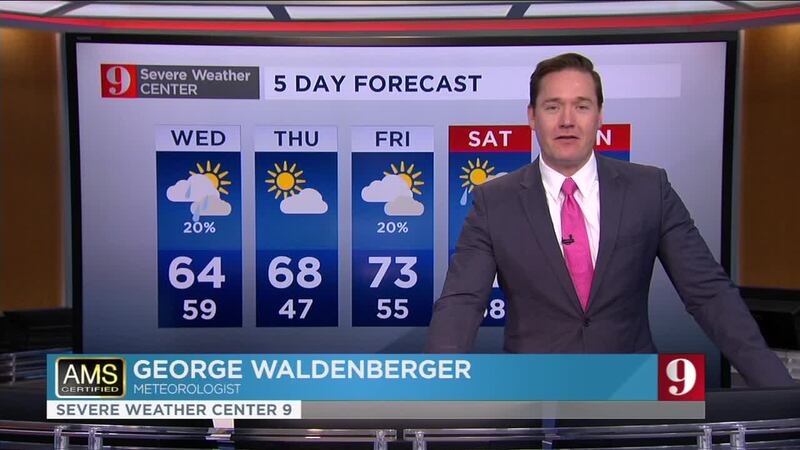
Catch up on your 5-day forecast:

Follow our Severe Weather team on Twitter for live updates:
- Chief meteorologist Tom Terry
- Brian Shields
- Irene Sans
- Kassandra Crimi
- George Waldenberger
- Rusty McCranie

DOWNLOAD: Free WFTV News & Weather Apps
Cox Media Group


