>>> CLICK HERE FOR TUESDAY’S COVERAGE <<<
ORLANDO, Fla. — Hurricane Ian strengthened into a major Category 3 hurricane overnight.
>>> STREAM CHANNEL 9 EYEWITNESS NEWS LIVE <<<
11 p.m. update
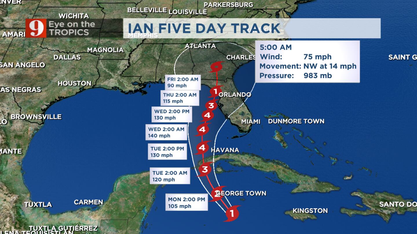
Ian continues strengthening, with winds now at 105 MPH.
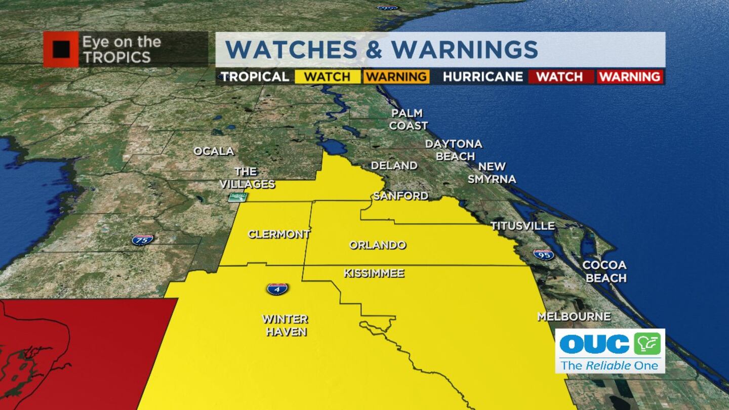
A tropical storm warning has been issued for Orange, Seminole, Lake and Osceola counties.
The forecast track has nudged a little farther east, with the center near Tampa Bay.
READ: Hurricane Ian: Disney World announces some temporary resort closures
Still, a broad range of landfall locations are possible between the Fort Myers area through Tampa up to Apalachicola Wednesday night and Thursday, depending on location.
The rapid intensification could lead to Category 4 status by Tuesday night.
Tropical storm warning issued for Orange, Lake, Seminole, Osceola counties. pic.twitter.com/djx6ptgZvR
— George Waldenberger (@GWaldenWFTV) September 27, 2022
10 p.m. update
According to the Walt Disney World website, the following resorts will close Wednesday through Friday due to weather:
- Disney’s Fort Wilderness Resort & Campground
- Copper Creek Cabins at Disney’s Wilderness Lodge
- Treehouse Villas at Disney’s Saratoga Springs Resort & Spa
- The Bungalows at Disney’s Polynesian Village Resort
Disney said it is contacting guests with current and upcoming reservations.
7:30 p.m. update
Hurricane Ian is bringing the threat of flooding to Seminole County.
See the full story below:

6:27 p.m. update
OCPS says all schools will be closed Wednesday and Thursday, and SCPS says its schools will be closed Wednesday.
Click here to see a full list of school closures.
6:20 p.m. update
Power companies across Florida are preparing for major outages due to Hurricane Ian.
Hear from local companies about their efforts below:
5:15 p.m. update
A tropical storm watch has been issued for all of Central Florida except a hurricane watch has been issued for Sumter County. Hurricane warnings are now in effect for the Tampa coast and south.
5PM #Ian: *NEW* Tropical storm watch for all of central Florida except a Hurricane Watch for Sumter. Hurricane warnings for Tampa coast and south. Big impacts! pic.twitter.com/L0S2A4t21H
— Tom Terry (@TTerryWFTV) September 26, 2022
5:10 p.m. update
As of the 5 p.m. update, Ian is now a Category 2 hurricane and is still expected to strengthen to Category 4. Ian is expected to strengthen to Category 3 before moving over Cuba overnight into tomorrow morning.
Here’s what else we learned from the new update:
- Dry Tortugas upgraded to a hurricane warning
- Tampa Bay upgraded to storm surge warning
- Flagler County beaches under a storm surge watch
5PM UPDATE...Ian at Category 2 now pic.twitter.com/lE6T8W754Q
— George Waldenberger (@GWaldenWFTV) September 26, 2022
4:30 p.m. update
The University of Central Florida announced that classes will be canceled Wednesday through Friday due to Hurricane Ian.
See a full list of university and public school closures here.
Read: Hurricane Ian: School closures in Central Florida
4:20 p.m. update
Channel 9 meteorologist George Waldenberge is timing out when Central Floridians can expect impacts from Ian to move in. See his latest timeline below:
"When does it get bad?"
— George Waldenberger (@GWaldenWFTV) September 26, 2022
Here's a look at our current Central Florida timeline with a nearby Hurricane Ian. Realize that flood threats can vary county by county where training rain bands set up and can be far east of the hurricane's center. pic.twitter.com/e76oeB3uQj
2 p.m. update
Gov. Ron DeSantis is providing an update on the state’s preparation for Hurricane Ian. Watch it live below.
>>>CLICK HERE TO WATCH THE GOVERNOR’S UPDATE<<<
12 p.m. update:
Federal Emergency Management Agency officials are giving an update on preparations for Hurricane Ian.
11 a.m. update:
Hurricane Ian has strengthened with winds now at 80 mph.
Rapid strengthening is still expected over the next 48 hours.
11am Friday Ian advisory: Winds up to 80mph. Rapid strengthen still expected the next 48 hours and Ian is forecast to become a Category 4 hurricane. The forecast calls for Ian to slow just west of Tampa, slowly weaken, and then move into the big bend on Friday morning. pic.twitter.com/hXS8f6erTa
— Rusty McCranie (@RMcCranieWFTV) September 26, 2022
Tropical storm watches have been issued for Lake, Orange, Osceola, Polk and Seminole counties.
Ian is forecast to become a Category 4 hurricane by Tuesday.
The forecast calls for Ian to slow just west of Tampa, slowly weaken, and then move into the Big Bend on Friday morning.
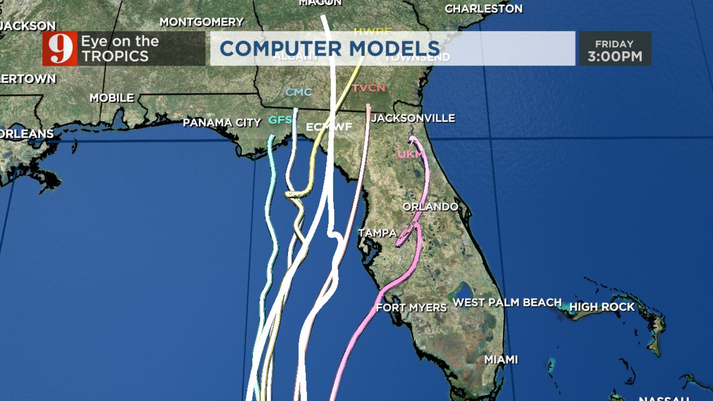
The latest run of tropical models keeps Ian just off the west coast and really slow it down on Wednesday and Thursday.
The latest run of tropical models. Most keep Ian just off the west coast, and really slow it down on Wednesday and Thursday. On this path, heavy rain, flooding, wind and tornado impacts all possible for Central Florida. Latest advisory from the NHC coming at 11am. pic.twitter.com/t9geBcKV4Z
— Rusty McCranie (@RMcCranieWFTV) September 26, 2022
On this path, heavy rain, flooding, winds and tornado impacts are all possible for Central Florida.
Original report:
Ian has maximum sustained winds of around 75 mph and is moving northwest at 14 mph.
The storm is moving into the eastern Gulf of Mexico over the next few days.
Read: Hurricane supply checklist: What should you include in your kit?
The entire state of Florida has been placed under a state of emergency as the massive storm’s patch continues its aim at the state.
Before the hurricane moves closer to Florida, it is forecast to make landfall in western Cuba on Monday night.
Ian is now a hurricane. Hurricane and tropical storm conditions are now LIKELY across Central Florida. Please ramp up the hurricane preparations today. I'm tracking this now on Channel 9. pic.twitter.com/qgYFwEttYE
— Brian Shields, WFTV (@BrianWFTV) September 26, 2022
Life-threatening storm surges and hurricane-force winds are expected in parts of western Cuba late Monday.
Tropical storm conditions are likely in Central Florida by Wednesday.
Read: Hurricane Safety: What are hurricane categories and what do they mean?
As rain bands move through Florida by Wednesday there will be a risk of tornados and flooding.
Ian will be just offshore of Tampa as a major hurricane Wednesday evening.
Read: Eye on the tropics: Here’s where you can get sandbags in Central Florida
The current track has Ian making landfall near Cedar Key, Florida.
>>> WATCH LIVE RADAR HERE <<<
Follow our Severe Weather team on Twitter for live updates:
Visit our hurricane section: EYE ON THE TROPICS
Click here to download the free WFTV news and weather apps, click here to download the WFTV Now app for your smart TV and click here to stream Channel 9 Eyewitness News live.

©2022 Cox Media Group


