ORLANDO, Fla. — 11 p.m. update:
Tropical depression 17 formed in the Atlantic Sunday night, according to the National Hurricane Center.
The system is expected to become a Tropical Storm on Monday.
Tropical Depression Seventeen has formed, forecast to strengthen into a tropical storm. Next name is Paulette. Another will likely develop on the heels of this system. #WFTV pic.twitter.com/dgHRZYi89x
— George Waldenberger (@GWaldenWFTV) September 7, 2020
The next named tropical storm will be Paulette.
Another tropical depression will likely develop on the heels of this system.
Tropical Depression #Seventeen Advisory 1: New Depression Forms Over the Central Tropical Atlantic. Expected to Become a Tropical Storm On Monday. https://t.co/VqHn0u1vgc
— National Hurricane Center (@NHC_Atlantic) September 7, 2020
Original report:
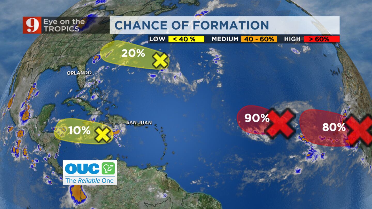
There are four tropical disturbances in the Atlantic this Labor Day weekend and one of them has a high chance of developing further.
So far, none of the disturbances pose a threat to Florida.
Here is an outlook for each disturbance and their chance of development, according to the National Hurricane Center.
Read: Busy season! Here are 9 stats for this season, so far
The good news is: there are no organized tropical disturbances in the Atlantic Basin now, but there are four areas with potential. The red areas show the highest chance of formation over the next five days, where tropical depressions are likely to form. pic.twitter.com/DjN0xS9VQI
— George Waldenberger (@GWaldenWFTV) September 6, 2020
Tropical disturbance 1 - 90% chance of developing
The first tropical disturbance is located about midway between the west coast of Africa and the Leeward Islands.
Weather officials said the storm is becoming better defined but its showers and thunderstorms remain disorganized.
They expect the system to develop gradually. A tropical depression is likely to form in the next day or so while it moves westward or west-northwestward across the central tropical Atlantic.
It has a 90% chance of forming in the next 48 hours.
Tropical disturbance 2 - 50% chance of developing
Weather officials said showers and thunderstorms are showing signs of organization with tropical disturbance 2. The disturbance is located just off coast of Western Africa.
The National Hurricane Center reported that gradual development of the system is expected and a tropical depression is likely to form by the middle of the week while it moves westward over the far eastern tropical Atlantic.
The system has a 50% chance of developing further in the next 48 hours. Over the next five days it has an 80% chance of formation.
Read: 9 tips on staying safe this Labor Day weekend
Tropical disturbance 3 - 10% chance of developing
A third tropical disturbance is located over the central Caribbean Sea and continues to produce disorganized showers and thunderstorms.
The storm has a very low chance of developing. Weather officials said development, if any, of this system should be slow to occur during the next day or two while it moves westward across the central and western Caribbean Sea.
The National Hurricane Center said unfavorable upper-level winds should limit the disturbance’s formation chances.
The chance of the storm developing further is 10% over the next 48 hours and 10% over the next five days.
Read: Severe weather awareness: Marine hazards and rip currents
Tropical disturbance 4 - 10% chance of developing
A trough of low pressure located a couple of hundred miles southeast of Bermuda is producing disorganized cloudiness and showers.
The system is moving west-northwestward.
It has a 10% chance of developing over the next 48 hours and a 20% chance of developing over the next five days.
Visit our hurricane section: EYE ON THE TROPICS
If we do see a new system named next week, it would be Paulette and then Rene.
Follow our Severe Weather team on Twitter for live updates:
- Chief meteorologist Tom Terry
- Brian Shields
- Irene Sans
- Kassandra Crimi
- George Waldenberger
- Rusty McCranie
Cox Media Group