A beautiful evening across Central Florida, under clear skies and mild temperatures while Karen dumps torrential rains over Puerto Rico and the Virgin Islands overnight.
Both Tropical Storm Jerry and Tropical Storm Lorenzo are set to stay offshore. Jerry will continue to weaken during the next few days passing just north of Bermuda, where they are under a Tropical Storm warning.
Lorenzo will strengthen, perhaps to major hurricane status by the week's end, but staying over water without threatening any land.
Tropical Storm Karen's potential impact on Florida is still unknown. Tropical Storm Karen’s track is beginning to show a bend to the west by Friday, but Channel 9 meteorologist Brian Shields said it's still too soon to tell where the storm will go from there.
We must continue to monitor as Puerto Rico and the Virgin Islands as they will continue to receive heavy rain which can trigger flash flooding and mudslides, overnight and through the day on Wednesday.
Karen's center is very broad, it crossed the eastern islands of Vieques and Culebra around 8 p.m. Tuesday.
Tropical Storm Karen will continue affecting the northeastern Caribbean through the evening but expect the rain and risk for flooding to be the greatest through Wednesday, with some islands still receiving Karen's rains through Thursday.
ORLANDO, Fla. — Rain totals between 2 to 4 inches with up to 8 inches in some isolated spots.
The seas will be rough, especially across southeastern Puerto Rico and the Virgin Islands (British and U.S.) 4 to 6 feet are expected and 8 feet possible.
Karen: Tuesday Update... Tropical Storm Karen moves into Puerto Rico & The Virgin Islands today. Rain/flood threat. We'...
Posted by Brian Shields, WFTV on Tuesday, September 24, 2019
We will continue to monitor this and bring you the latest on Eyewitness News, wftv.com and on our free WFTV Weather app.
WEEKLY FORECAST
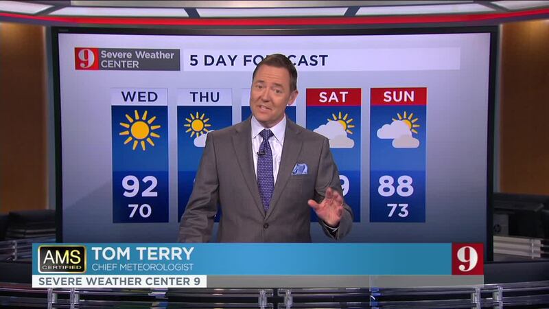
Shields said this week's forecast calls for a dry weather pattern with highs near 90 and nearly no chances for rain.
Catch up on your full five-day forecast below:
Follow our Severe Weather team on Twitter for live updates:
- Chief meteorologist Tom Terry
- Brian Shields
- Irene Sans
- Kassandra Crimi
- George Waldenberger
- Rusty McCranie

Cox Media Group


