
ORLANDO, Fla. — >>> CLICK HERE TO WATCH LIVE RADAR <<<
Central Floridians woke up to cool fall temperatures Tuesday morning. For Wednesday morning, temperatures will feel even cooler in many areas.
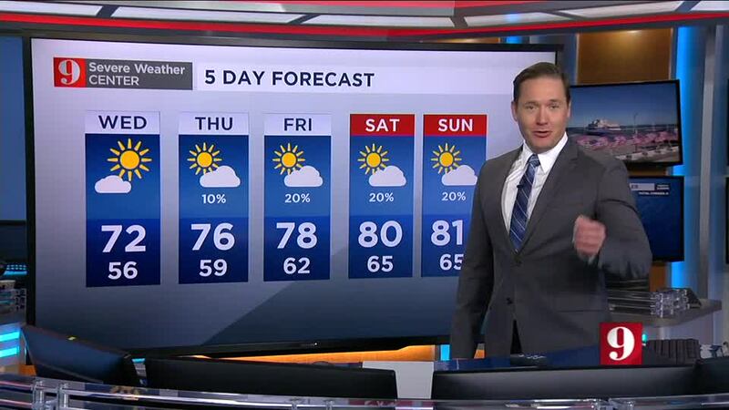
Orlando’s forecast morning low for Wednesday is 56, just one degree away from our coolest morning on November 3. Some Marion County locations will wake up to the 40s.
WATCH: Historic crewed mission successfully blasts off from Kennedy Space Center
Daytime temperatures will only reach the low 70s Wednesday in Orlando, with some neighborhoods to the north of Orange County staying in the 60s all day.
This Central Florida ‘cool snap’ will last through the late week and the 80s return for the weekend.
In the tropics, Iota has weakened to a tropical storm Tuesday, but still poses a threat for flash flooding. The storm made landfall Monday night about 12 miles south of where Hurricane Eta made landfall as a Category 4 hurricane earlier this month.
Watch your full five-day forecast below:
Stay tuned to Channel 9 Eyewitness News for your latest forecast updates.
Visit our hurricane section: EYE ON THE TROPICS
Visite la sección en español: Temporada de huracanes
Follow our Severe Weather team on Twitter for live updates:
- Chief meteorologist Tom Terry
- Brian Shields
- Irene Sans
- Kassandra Crimi
- George Waldenberger
- Rusty McCranie


