ORLANDO, Fla. — A major storm system is moving over Central Florida, bringing with it several inches of rain, gusty winds and chilly temperatures. Download the free WFTV weather app here, and read live updates below:
>>> STREAM CHANNEL 9 EYEWITNESS NEWS LIVE <<<
4:30 p.m. Update
Our Florida storm system is now off the northeast coast of Florida and moving away.
The rough surf, strong winds and coastal flooding will take a day or two to subside, and we just have one more element to deal with, the coolest air yet this season for the next two nights.
The final push of rain is slowly tapering over parts of Flagler and Volusia Counties, the winds persist and the cooler air is moving in. Now get ready for the coldest weather yet this season tonight through tomorrow morning. Monitor weather today with https://t.co/cNHkwRXBg2 pic.twitter.com/dW4l5ySMp6
— George Waldenberger (@GWaldenWFTV) November 6, 2021
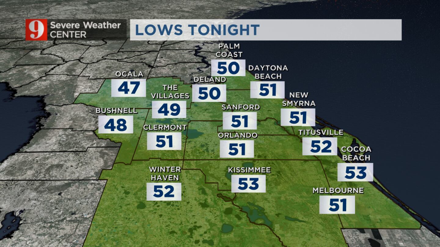
We will feel lows in the 50s in Orlando with the next couple of mornings in the upper 40s to the northwest.
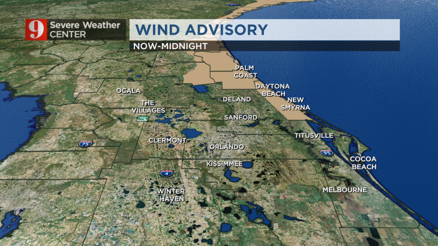
Ongoing alerts include a high surf advisory, a gale warning for our coastal waters, a coastal flood warning, a dangerous risk of rip currents and a wind advisory for Flagler and coastal Volusia Counties.
1 p.m. update
The final push of rain is slowly tapering over parts of Flagler and Volusia counties, while the winds persist and the cooler air is moving in, Channel 9 meteorologist George Waldenberger said.
“Get ready for the coldest weather yet this season tonight through tomorrow morning,” Waldenberger said.
Wind chill values will be in the 40s for many of us tonight.
Click here to download the free WFTV news and weather apps, click here to download the WFTV Now app for your smart TV and click here to stream Channel 9 Eyewitness News live.
We continue to track this strong storm system.
— Kassandra Crimi (@KCrimiWFTV) November 6, 2021
Today will be very windy with a decreasing rain chance.
These winds will usher in MUCH colder air. Get ready for 40s and 50s! pic.twitter.com/MxnrZERHBr
11 a.m. update
Flagler Beach Pier is temporarily closed to do high wave activity from the Nor’easter, police said Saturday morning.
The pier will be inspected for reopening when conditions improve.
The Flagler Beach Pier has been temporarily closed due to high wave activity from the Nor’easter. When conditions improve, the Pier will be inspected for reopening. Stay safe! #flaglgerbeach pic.twitter.com/ehBDDd5k09
— Flagler Beach Police (@FBPD) November 6, 2021
10 a.m. update
Drier skies have started to take hold over most of Central Florida. We will keep our rain chance on the low side through the remainder of the day as this strong storm continues to pull east.
Although rain will not be much of an issue today, it will be very windy. Wind gusts are expected to reach 20-40 MPH today. This will help usher in cooler weather. Highs today will be about 20 degrees below normal. They will peak in the 50s and 60s. Tonight it gets cold.
Lows are forecast to be in the 40s and 50s.
7 a.m. update
It will stay very windy on Saturday, especially along the coastline.
There is a wind advisory is in place for Flagler and Coastal Volusia Counties, now through midnight.
Sustained winds will reach 0-30 mph, with gusts hitting highs of 30-40 mph.
5 a.m. update
Still tracking scattered showers this morning for our northern zones, with sprinkles elsewhere. Winds will crank up today. Gusting up to 20-40mph this afternoon.
Beaches will be rough. We will see high and dangerous surf. Coastal flooding and beach erosion will be possible.
Gusty winds are bringing in the chill! See you on Channel 9! pic.twitter.com/d27lKbirk4
— Brian Shields, WFTV (@BrianWFTV) November 6, 2021
The strong winds that we’ll experience today will usher in some pretty cool air.
Saturday night will see lows in the 40s and 50s. High will be in the 60s all weekend long.
Click here to download the free WFTV news and weather apps, click here to download the WFTV Now app for your smart TV and click here to stream Channel 9 Eyewitness News live.