
ORLANDO, Fla. — A major storm system continues to move over Central Florida bringing with it several inches of rain, gusty winds and chilly temperatures. Download the free WFTV weather app here, and read live updates below:
>>> STREAM CHANNEL 9 EYEWITNESS NEWS <<<
>>> STREAM LIVE RADAR <<<
7:00 a.m. Update:
It will stay very windy on Saturday, especially along the coastline.
There is a wind advisory is in place for Flagler and Coastal Volusia Counties, now through midnight.
Sustained winds 2will reach 0-30 mph, with gusts hitting highs of 30-40 mph.
5:30 a.m. Update:
Still tracking scattered showers this morning for our northern zones, with sprinkles elsewhere. Winds will crank up today. Gusting up to 20-40mph this afternoon.
Beaches will be rough. We will see high and dangerous surf. Coastal flooding and beach erosion will be possible.
Gusty winds are bringing in the chill! See you on Channel 9! pic.twitter.com/d27lKbirk4
— Brian Shields, WFTV (@BrianWFTV) November 6, 2021
The strong winds that we’ll experience today will usher in some pretty cool air.
Saturday night will see lows in the 40s and 50s. High will be in the 60s all weekend long.
11 p.m. update
Heavy rain and winds have brought the St. Johns River to the moderate flood stage level in North Lake County, bringing with it a risk of flooding into homes over the weekend.
Heavy rain and winds backing up the St Johns River have brought river levels to moderate flood stage at Astor in northern Lake county. This will bring water up into many homes and yard along the river this weekend. pic.twitter.com/NF1zyf4rtW
— Tom Terry (@TTerryWFTV) November 6, 2021
9 p.m. update
Gusts of wind are expected later Friday and early Saturday, with coastal flooding expected during high tides at 9:30 p.m. and 9:30 a.m., Channel 9 Certified Chief Meteorologist Tom Terry said.
Our surface low is forming off Volusia county, you'll note the swirl in the radar echoes offshore. Gusts to 50mph+ are expected later tonight and early on Saturday. Coastal flooding is expected during the ~9:30pm and ~9:30am high tides. #WeatherAlertDay. pic.twitter.com/iwjZQ7DumS
— Tom Terry (@TTerryWFTV) November 5, 2021
It's 8:30pm and we're an hour away from high tide in Daytona Beach. He's a live look at the surf and wind that continues to lash the coastline. pic.twitter.com/0Dg3GVRCVU
— Rusty McCranie (@RMcCranieWFTV) November 6, 2021
5:45 p.m. update
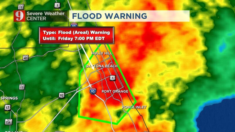
Parts of Volusia County were placed under a flood warning Friday afternoon.
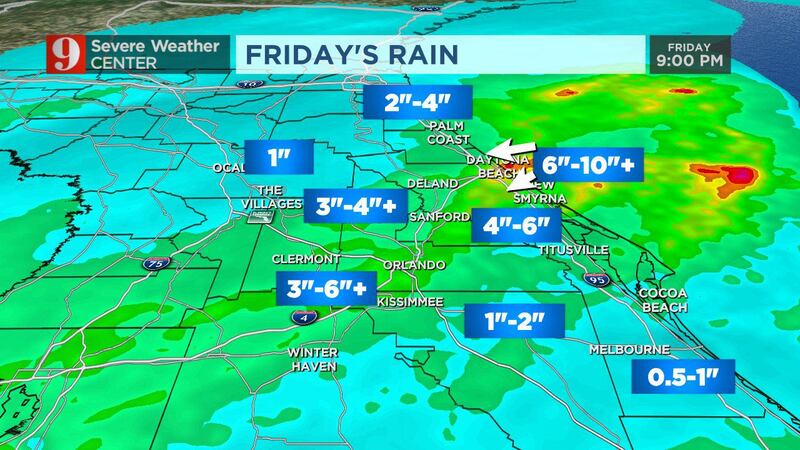
Areas in and around Daytona Beach have received 4 to 6 inches of rain.
Flood Warning now in effect for parts of Volusia County, including the Daytona Beach area until 7pm. 4-6" of rain has fallen in parts of this area, and another 2-3" is possible. Flooding of waterways and low-lying areas are likely. pic.twitter.com/4zkGiRC96L
— Rusty McCranie (@RMcCranieWFTV) November 5, 2021
The flood warning is set to last until 7 p.m. with another 2 to 3 inches of rainfall likely in the area.
4:30 p.m. update
Peak wind gusts have been in the 30 mph range for some in Central Florida.
Flagler Beach has reported winds up to 46 mph.
It’s a wet day at the office. @WFTVWeather pic.twitter.com/CJteX1yR9e
— Tom Terry (@TTerryWFTV) November 5, 2021
Costal storms will bring winds up to 45 mph for some by Saturday as the gale nor’easter system cranks up.
As of Friday afternoon, there are no reports of major flooding or damage in Central Florida.
All this rain and #Orlando looks like #IslaNublar pic.twitter.com/7TwSZQHkNY
— George Waldenberger (@GWaldenWFTV) November 5, 2021
12:10 p.m. update
Some locations have already seen more than 1 inch of rain, and there’s more to come.
Some locations have already seen 1"+ of rain, and there's more to come. Join us over on @WRDQ for the latest. @VEcholsWFTV pic.twitter.com/2EW8kFyQj7
— Kassandra Crimi (@KCrimiWFTV) November 5, 2021

10:35 a.m. update
The shield of rain is here, and coastal flooding is possible. Channel 9 meteorologist Brian Shields said winds will gust 30-50 mph.
The shield of rain is here, and coastal flooding is possible.
— Brian Shields, WFTV (@BrianWFTV) November 5, 2021
Winds will gust 30-50 mph...
Take a look...https://t.co/7rGTYyKc0C
8:45 a.m. update
If your weekend plans included some slipping and sliding at area water parks, put the brakes on your raft.
Thanks to unfavorable weather, Central Florida’s theme park giants announced the closures of their water resorts. Read more here.
READ: Stormy weather: These local water parks will be closed today
6:10 a.m. update
Stronger storms are moving into Central Florida now.
Channel 9 meteorologist Brian Shields said the weather on Saturday and Sunday could best be compared to a tropical storm with the biggest threat being downed tree branches.
>>> CLICK HERE TO DOWNLOAD THE WFTV WEATHER APP <<<
It’s moving in now… Tracking live on @wftv… pic.twitter.com/TakMBZKdxp
— Brian Shields, WFTV (@BrianWFTV) November 5, 2021
5 a.m. update
Channel 9 meteorologist Brian Shields said the storm system is moving in to Central Florida causing winds to pick up and heavy rain in our southern zones.
He said the strongest winds will be tonight and early tomorrow.
Shields is tracking the wind and rain city-by-city now on Channel 9. Click here to tune in.
The storm system is moving in... Winds are picking up. Heavy rain in our southern zones. Strongest winds will be tonight and early tomorrow. Covering the city-by-city winds/rain, now on Channel 9! pic.twitter.com/I3uKcPTFLi
— Brian Shields, WFTV (@BrianWFTV) November 5, 2021
ORIGINAL STORY
Rain is already building south and off in the Gulf, and will make for a wet morning commute, with locally heavy rain becoming more prevalent by the afternoon.
Heaviest totals are expected at the coast and may also extend north of Orlando with 3 to 6 inches possible. Water run-up along the beaches is possible by high tide both Friday and Saturday, at roughly 9 a.m. and 9 p.m.
READ: Zillow to sell off hundreds of Orlando homes after homebuying division crumbles
Our models differ as to where the heaviest rain bands will set-up at the coast, but all agree on a wet and windy 2 days ahead for #DaytonaBeach! #WeatherAlertDay @WFTV pic.twitter.com/gMNOJAP179
— Tom Terry (@TTerryWFTV) November 5, 2021
Flood Watches are out for our coast as 3 to 6 inches of rain is expected with a big Florida-style Nor’Easter that will bring widespread rain and gusty winds over 40-50 mph, especially late Friday and on Saturday, Channel 9 Chief Meteorologist Tom Terry said.
Coastal flood advisories for rough seas and coastal erosion are in effect as well.
READ: What is the difference between a tornado warning and a tornado watch?
Winds start to really crank up Friday night and on Saturday, especially at the coast, with gusts over 50 mph possible.
Winds start to really crank up Friday night and on Saturday, especially at the coast. Gusts over 50mph possible. #StormAlert9 pic.twitter.com/OLlBy2yjhw
— Tom Terry (@TTerryWFTV) November 4, 2021
All of this will bring in much cooler weather this weekend. By Sunday morning, we’ll have temperatures dipping into the 40s and 50s.
It's a Weather Alert Day ~ our big storm system is moving in. Rain entering now...picking up throughout the day. Gusty winds ahead. Busy! LIVE ON 9... pic.twitter.com/npe0KJgDKd
— Brian Shields, WFTV (@BrianWFTV) November 5, 2021
Visit our hurricane section: EYE ON THE TROPICS
Follow our Severe Weather team on Twitter for live updates:
Click here to download the WFTV weather app for live updates to your phone, and click here to stream weather coverage on the WFTV now app
©2021 Cox Media Group


