
ORLANDO, Fla. — >> CLICK HERE FOR LIVE DOPPLER 9 RADAR <<
>> WATCH OUR NEWSCAST LIVE HERE <<
6:30 p.m. update
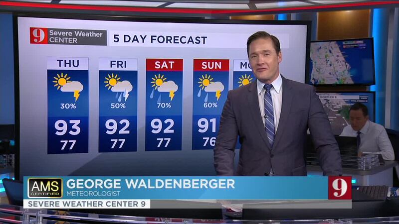
A slight change from all the storm activity we’ve had the last few days. A patch of drier air in the upper levels of the atmosphere will move over Central Florida on Thursday and limit the storms that could for in the afternoon. It will not be completely dry for everyone, but only about 20 percent of Central Florida could have some storms develop.
With the lack of numerous showers and storms that usually would cool us down, we can expect the temperatures to reach the low 90s, with heat indices reaching the triple digits, especially for inland locations. The temperatures along the coast will remain less warm along coastal locations.
Rain returns to about 40 percent of Central Florida on Friday and tropical moisture arrives by the weekend damping it.
6:10 p.m. update
Central Florida: Here are your estimated totals in the last 3 hours.. Storms are still strong over #Lake Co., Southern #Sumter #Seminole and northern #Orange Co. #FLwx pic.twitter.com/iblfqIgQ8h
— Irene Sans (@IreneSans) July 15, 2020
4:45 p.m. update
Storms are lining up along the Turnpike and I-4 developing lots of lightning and possible flooding as they lose speed. In the last 15 minutes, it seems like this batch is losing a bit of strength as the storms expand and become more splattered over Central Orange county and Osceola to the east.
Another strong batch is lining up from Downtown Orlando northwest to the Eutis area. There could be some minor flooding also developing in this area.
Previous version:
Storm chances will increase throughout the day Wednesday.
Make sure to always have at least three ways of receiving weather alerts. You can download our Free WFTV Weather App (make sure to allow notifications) to receive alerts wherever you are located.
Here’s what you can expect:
- Highs will be in the low-90s, but heat indices will be around 103 to 105 degrees.
- The weather will remain mostly unstable. The sea breezes, from both coasts, will develop and produce strong thunderstorms across inland locations.
- Inland storms will be strong and some could turn severe. Expect frequent likely and some strong gusts.
- As the storms try to retract they can produce torrential downpours which can lead to minor flooding for some. Please avoid flooded streets.
- Storms will be shortly after sunset for most of Central Florida.
- Evening temps will drop to the upper 70s.
Read: Saharan Dust coming to Central Florida: What is it? What does it do?
DOWNLOAD OUR FREE WFTV WEATHER APP TO RECEIVE ALERTS
Read: Forecasters highly confident about an active 2020 Hurricane Season
Watch your 5-day forecast below:
Entérese de todo lo que ocurre en el trópico en nuestra pagina en español.
Follow our Severe Weather team on Twitter for live updates:
- Chief meteorologist Tom Terry
- Brian Shields
- Irene Sans
- Kassandra Crimi
- George Waldenberger
- Rusty McCranie
© 2020 Cox Media Group


