
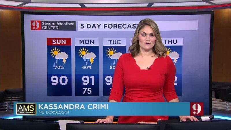
A muggy but drier morning Sunday will lead to increased shower activity later in the day.
Showers and storms will start to develop in the midday as high temperatures reach the upper 80s to lower 90s.
Download the WFTV weather app | Hour-by-hour in your city
Expect shower activity to move from west to east across the state in the early afternoon.
Residents should keep watch for numerous showers and storm activity Saturday evening with lightning and some downpours possible in areas.
Overall, Central Florida is forecast to have a 70 percent chance of rain for Sunday with some areas possibly getting more than an inch of rain.
Rain chances are forecast to stay around 50 to 60 percent throughout the rest of the week.
Rain totals through 6pm. More moving in now! Live coverage on @WFTV pic.twitter.com/9zhvjAHQgN
— tom terry (@TTerryWFTV) June 9, 2019
Here's the second round of storms developing to our SW I was mentioning earlier. I'll be updating our evening storm outlook live on @WFTV at 6pm. #ChiefOnDuty :) pic.twitter.com/npHutFkGjM
— tom terry (@TTerryWFTV) June 9, 2019
Severe focus shifting toward Volusia beaches now: #DaytonaBeach #NewSmyrna. If you have friends or loved ones at the beach, give them a call and let them know weather's on the way! #StormAlert9 pic.twitter.com/euEJVmgfUu
— tom terry (@TTerryWFTV) June 9, 2019
Be safe! Severe winds over 50mph and frequent lightning moving NE through eastern Orange and Seminole counties. #WinterPark #UCF #Oviedo #WinterSprings #OIA, #LakeNona #Avalon #Alafaya pic.twitter.com/W7X1IknHGZ
— tom terry (@TTerryWFTV) June 9, 2019
New warning for strong damaging winds in SE Marion county. Moving NE at 40mph. #StormAlert9 pic.twitter.com/W3cKepCbPG
— tom terry (@TTerryWFTV) June 9, 2019
Flights will likely be delayed next hour or so as heavy storms impact OIA airspace. @WFTV pic.twitter.com/66pejglHyl
— tom terry (@TTerryWFTV) June 9, 2019
Severe storm, winds to 60mph, penny hail possible in #TheVillages #LadyLake #Coleman #Wildwood #Leesburg. Moving NE at 40mph. pic.twitter.com/8IIkHiiLPU
— tom terry (@TTerryWFTV) June 9, 2019
Storms moving NNE at 15-20mph, with an outflow boundary/seabreeze lurking east of Orlando that should create stronger storms near 417 and 46. #StormAlert9 pic.twitter.com/LUNSxwClEQ
— tom terry (@TTerryWFTV) June 9, 2019
Storms moving NNE at 15-20mph, with an outflow boundary/seabreeze lurking east of Orlando that should create stronger storms near 417 and 46. #StormAlert9 pic.twitter.com/LUNSxwClEQ
— tom terry (@TTerryWFTV) June 9, 2019
Heavy storms just west of downtown #Orlando, moving east at 15mph. Going to be an active rest of the afternoon across central Florida. @WFTVWeather app is always at the ready for you. #StormAlert9 pic.twitter.com/hLtnHTId51
— tom terry (@TTerryWFTV) June 9, 2019
Very strong winds near 50mph moving into southern Osceola county, about 15mi south of Harmony. #StCloud #Kissimmee. pic.twitter.com/uI2blba6eb
— tom terry (@TTerryWFTV) June 9, 2019
Busy afternoon of storms, with severe ones in southern Brevard #PalmBay #Melbourne, and others in the southern Polk, and moving into southern Osceola county. Track them anytime on our @WFTVWeather app. #StormAlert9 pic.twitter.com/T84QVOm5WG
— tom terry (@TTerryWFTV) June 9, 2019
Isol'd storms firing near the coastline, now. Expect more rain and storms throughout the day. pic.twitter.com/d8kXx0VW92
— Kassandra Crimi (@KCrimiWFTV) June 9, 2019
Follow our Severe Weather team on Twitter for live updates:
- Chief meteorologist Tom Terry
- Brian Shields
- Irene Sans
- Kassandra Crimi
- George Waldenberger
- Rusty McCranie

Cox Media Group


