ORANGE COUNTY, Fla. — 8:00 p.m.
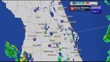
Storms have parked over interstate 4, producing heavy rainfall amount in a short time period, prompting areal flood advisories. The advisories are set to expire by 9 p.m., when storms are expected to diminish. Please avoid areas where water is accumulated, minor flooding could be occurring in parts of Orange County northward to Seminole County.
Road mess: Flooding closes 2 lanes of I-4 near downtown Orlando, Universal
Another flood advisory. Central Orange, including Orlando, Ocoee, Winter Garden, Winter Park & Windermere have received ove 1.5 inches and this storms could produce another 2 inches rapidly. Stay away from flooded areas. #stormalert9 pic.twitter.com/jYyPMMsT86
— Irene Sans (@IreneSans) May 16, 2018
Areas in NW Orange, E. Lake Co. have accumulated over 3in or rain in the last 6 hours. Same area now dealing with torrential rain which may be causing minor flooding. Stay away from flooded areas.
— Irene Sans (@IreneSans) May 16, 2018
-- Apopka, Mount Plymouth, Cassia, Zellwood And Debary. -- pic.twitter.com/xrIirAqizt
The tropical airmass stays put on Thursday. Showers and thunderstorms will once again affect Central Florida. Scattered showers during the late morning, and with the heating of the day and sea breezes igniting, thunderstorms will once again get going, just in time for the afternoon. The threats for Thursday's storms are frequent lightning, gusty winds and minor flooding. Another 3 inches could be accumulating in parts of Central Florida. By the end of this week the overall totals could be approaching 10 inches.
Happens too often.
— Irene Sans (@IreneSans) May 16, 2018
2 people struck by #lightning in a field in Parkland, FL. Woman died, man is in the hospital.
So far this year 2 people have died because of lightning, one man in Texas in February, and now one woman in Florida.
This should never happen. pic.twitter.com/JQVkY86y5X
5:00 p.m.
Shortly after 4 p.m. Wednesday, a trainer spotter reported a funnel cloud west of I-95 by exit 220 (Garden Street exit) in Brevard County. No reports of injuries or damage as of now. Funnel clouds, waterspouts and tornadoes are typical of tropical airmass, like the one dominating this week Florida.
Make sure to stay weather aware and keep an eye on the sky. Storms will continue to develop frequent lightning and lightning can strike miles away from the base of a thunderstorm. If you are outside, head indoors as soon as you hear thunder. This is not a good day to be outdoors.
Scattered storms will linger until around 10 p.m. and weakening after sunset.
Storms crossing I-95 near Titusville responsible for funnel cloud report, looked like scud by the time we got to them. #WFTV #Florida #Orlando #titusville pic.twitter.com/UXnRmt7gt7
— George Waldenberger (@GWaldenWFTV) May 16, 2018
:quality(70)/d1hfln2sfez66z.cloudfront.net/11-13-2019/t_2a8d0e6ffcac4ab9a1c1f9fa27425ab8_name_41D12C48FBE240C18C6F8AAD4E1A399B_2.jpg)
3:15 p.m.
Plenty of moisture continues to stream in from the south right over Central Florida. Some neighborhoods across the the region have enjoyed some partly sunny skies during the first part of the afternoon, while others have remained under mostly cloudy skies.
This period of partly sunny skies may provide enough heating to create some thunderstorms within the next couple hours through the early evening.
This afternoon the thunderstorms will be isolated and a bit more limited than yesterday, due to the lack of deep moisture in the upper levels of the atmosphere. Don't let your guard down, as the isolated storms that do develop over Central Florida could still be strong.
Dissipating low pressure(en español abajo) Although we see some breaks in the deep moisture in the upper levels of the atmosphere (the low pressure over the Gulf of Mexico has weakened significally) we still have PLENTY of moisture over the surface coming from the South over Florida. There are parts of Central Florida even enjoying partly sunny skies, but with a bit of sunshine comes heat, and the heat sparks thunderstorms. Don't let your guard down, we could still see some scattered thunderstorms over Central Florida through the early evening.. Aunque vemos algunas rupturas en la humedad en niveles superiores de la atmósfera (la baja presión sobre el Golfo de México se ha debilitado significativamente) todavía tenemos MUCHA humedad procedente del sur sobre Florida en la superficie. Hay partes de la Florida Central que incluso disfrutan de cielos parcialmente soleados, pero con un poco de sol llega el calor y el calor inicia tormentas eléctricas. No baje la guardia, todavía podríamos ver algunas tormentas dispersas sobre la Florida Central a través de la tarde.
Posted by Irene Sans on Wednesday, May 16, 2018
11:30 a.m.
Rain continues to develop and move into Central Florida. Heavy rain and storms likely again this afternoon.
Here are the storm threats for this afternoon. Watch out for very heavy rain and tremendous lightning. pic.twitter.com/84MrOJ0B84
— Rusty McCranie (@RMcCranieWFTV) May 16, 2018
8:40 a.m.
You'll be able to feel the humidity Wednesday before the rain arrives.
There is a low-end risk of a brief tornado or waterspout in Central Florida, according to according to certified meteorologist Brian Shields.
We still run the low-end risk of a brief tornado or waterspout (tornado over water) today...we'll monitor. Live on Channel 9... pic.twitter.com/Eu6DpkLWKb
— Brian Shields (@BrianWFTV) May 16, 2018
4:15 a.m.
You will want to keep the umbrellas handy again as storms move into Central Florida on Wednesday.
The day will start off with sun and some clouds, but the rain and storms will develop in the late morning through the afternoon, according to certified meteorologist Brian Shields.
There is a 70 percent chance some of the storms could be severe.
We still run the low-end risk of a brief tornado or waterspout (tornado over water) today...we'll monitor. Live on Channel 9... pic.twitter.com/Eu6DpkLWKb
— Brian Shields (@BrianWFTV) May 16, 2018
*BETTER LOOK* CRASH #I4: Crash on I-4 Westbound in the John Young Pkwy merge lane. DELAYS: Traffic slow starting at Kaley Ave. DRIVE TIME: 15+minutes pic.twitter.com/uYL68jctUf
— Racquel Asa (@RAsaWFTV) May 16, 2018
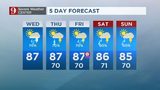
Watch below: 5 day forecast:
1-3" of rain for many of us yesterday - and again today! See you on 9 & Good Morning!! pic.twitter.com/6Chcwpayty
— Brian Shields (@BrianWFTV) May 16, 2018
Watch below: Brian Shields full forecast:
Cox Media Group
:quality(70)/cloudfront-us-east-1.images.arcpublishing.com/cmg/2GID2POODRD5ZK3FEB6IC2QIIY.png)
:quality(70)/cloudfront-us-east-1.images.arcpublishing.com/cmg/DVAWDEDUTFAXLMP2SEDK6PMIWU.jpg)
:quality(70)/cloudfront-us-east-1.images.arcpublishing.com/cmg/GRZGPKEIUVHVFAVEGSOJSRA6JQ.jpg)
:quality(70)/cloudfront-us-east-1.images.arcpublishing.com/cmg/GA37OK4AEFED7JLU5V5MFGYPWU.jpeg)
:quality(70)/cloudfront-us-east-1.images.arcpublishing.com/cmg/VR3AT26J4NFCNM5OQP5A44M3OI.jpeg)