
ORLANDO, Fla. — Update:
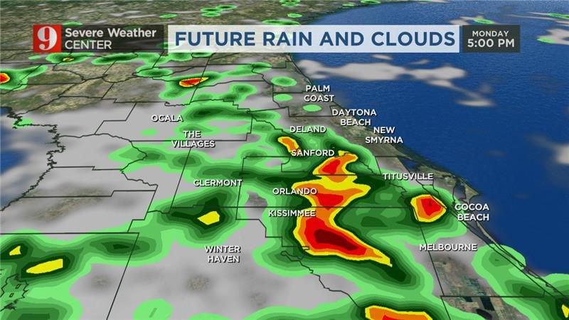
Powerful thunderstorms were rolling into metro Orlando on Monday afternoon.
>>> STREAM CHANNEL 9 EYEWITNESS NEWS LIVE <<<
The storms are moving along Interstate 4 and arrived at the coast by 4 p.m.
Gusty winds over 50 mph and lots of lightning are expected.
Read: Here’s how hot and extreme the summer has been & we’re only halfway over
Heavy rainfall exceeding 2 inches could lead to some slow downs on the roads.
Pockets of damaging wind, lightning, and localized street flooding will be threats throughout the afternoon across Central Florida.
Chief meteorologist Tom Terry is tracking the storms and will update you on Channel 9 Eyewitness News.
Click here to download the free WFTV weather app.
The first storms have already formed with a severe t-storm warning between The Villages and Belleview through 1:30pm. Pockets of damaging wind, lightning, and localized street flooding will be threats through the afternoon across Central Florida. pic.twitter.com/USyGCyUf1A
— George Waldenberger (@GWaldenWFTV) July 31, 2023
Previous story:
Central Florida will be very hot and humid Monday.
The high temperature will reach around 93 degrees in the afternoon.
Read: Man attacked by shark off west-central Florida beach
The heat index, or feels-like temperature; will be around 115 degrees when you factor in both heat and humidity.
Some storms will develop later in the day and some areas could see strong to severe storms.
Read: Back-to-school event will raise money for Seminole County schools
Our area will have a 60% chance of seeing rain and storms Monday.
Channel 9 meteorologists are also monitoring two areas that may show tropical development.
Read: ‘Gray Man’ ghost makes appearance before major hurricanes, legend says
If one of the two storms gets a name, it will be Emily.
Thankfully, neither of the storms are forecast to be a threat to the United States.
Follow our Severe Weather team on Twitter for live updates:

©2023 Cox Media Group


