
ORLANDO, Fla. — >> CLICK HERE TO WATCH LIVE DOPPLER 9 <<
Central Florida got a break from intense storm activity until the afternoon hours. The constant stream of thick clouds kept the temperatures between the upper 70s and low 80s, not allow the atmosphere to becomes unstable, keeping thunderstorms from developing.
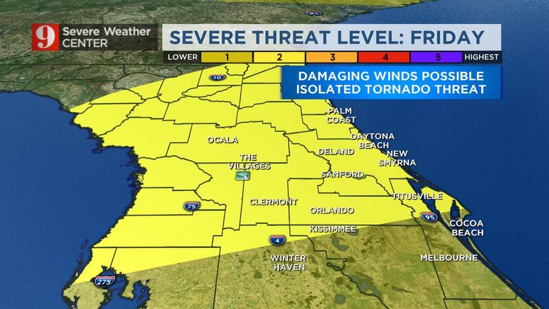
The isolated ran-showers will continue to affect mainly our southern tier counties, like Polk, Osceola, and Brevard. Rainfall totals for this storm system will be higher around this area, with some spots reaching 4 inches.
The weekend doesn’t look too bad as far as intense downpours. About 30 percent of Central Florida could receive measurable rain, isolated storms are possible mainly over southern counties too. Another cold front is forecast to bring rain and storm chances, not as intense during the evening on Saturday and early Sunday. Showers will end early on Sunday. The temperatures will be slow to fall, though
The temperatures will be in the warm side. Highs on Saturday and Sunday will be at 90 or very close to 90 degrees. The winds will be from the west on Saturday, and although there will be a cold front passing over Central Florida, the cooler air mass will arrive Monday. Highs on Sunday between the mid to upper 80s.
The beginning of next week will be much cooler, with temperatures at least closer to the average for this time of the year, and partly to mostly sunny. Humidity will also feel very comfortable on Monday and Tuesday.
Morning updates:
9 a.m.
The threat of severe storms this Friday morning has diminished across Central Florida. There is still a chance for scattered showers, but overall conditions will gradually start to improve for the rest of the morning.
Make sure to stay away from flooded areas. Poor drainage areas may easily flood.
— Irene Sans (@IreneSans) April 24, 2020
Turn Around Don't Drown.
Advertencia por inundación. Zonas con mal drenaje pueden inundarse. Calles pueden estar inundadas, no intente cruzar. Tome vía alterna #stormalert9 pic.twitter.com/yBPr44q5pH
7:45 am.
LAKE County, Tornado Watch has been canceled for you too.
— Irene Sans (@IreneSans) April 24, 2020
Slowly but surely the threat for severe weather diminishes. pic.twitter.com/DH9vSKfMIa
7:15 am.
Southeastern Oange and northeastern Seminole counties are under a severe thunderstorm warning until 7:45 a.m. Damaging wind gusts above 60 mph.
These storms will continue to move to the northeast and could impact Titusville, Rockledge, Cocoa, Cocoa Beach and Cape Canaveral next.
WOAH!! Sunrise just in time to catch these! Thank you so much @jose97luis! https://t.co/0pSnUeU7xh
— Irene Sans (@IreneSans) April 24, 2020
. @OUCreliableone Reports over 2,000 customers without power just east of St. Cloud, south of Narcoossee.
— Irene Sans (@IreneSans) April 24, 2020
This area had a round of storms ahead of the main line of storms. The line will arrive in by 8am. #StormAlert9
6:15 a.m.
The tornado watch was canceled for Marion County but remains in effect for the rest of Central Florida. As the line of storms moves south, expect the threat for severe weather to diminish once it was stormed over that area.
Stay weather aware, some power outages have been reported in Flagler county.
Marion County the threat for Tornado has ended. The tornado watch has been canceled. #Stormalert9https://t.co/PAh1UtzTG8
— Irene Sans (@IreneSans) April 24, 2020
La vigilancia por tornado se cancela para el condado Marion. El riesgo de tornado culmina para esta zona. pic.twitter.com/vvuJdS9AeR
5:45 a.m.
Severe storms continue to move over Central Florida, inching closer to Seminole and Orange counties. The line of storms is about 30 miles to the northwest of Orlando. Expect the line of storms to be over Metro areas by 7 a.m.
The storms have a history of turning severe and we already a tornado warning over Marion county. Also, tornadic activity has been reported over the Tampa area. The storms in the Tampa area are the ones that will be moving to Metro Orlando after 7 a.m.
Previous story:
Widespread storms will start to pop up across Central Florida early Friday morning. Before sunrise, there could be a couple strong to severe storms already popping across parts of Central Florida.
The main line of storms is moving slowly eastward, although the storms are moving to the northeast. Expect this line of storms to arrive over portions of Marion county shortly after 3 a.m. Storms will grow in coverage and intensity by sunrise, this is when we can expect the highest chance for severe storms to come into the Metro area.
As the storm, very slowly move to the east the chance for severe weather will continue to spread across Central Florida. There is a good chance to have some areas with minor to moderate flooding due to the storms moving so slowly, and because there is the chance to have widespread rain after the main storm-line passes through.
Make sure to have at least three ways of receiving alerts. Download our free WFTV Weather App
THREATS:
- Damaging winds gusts of at least 50 mph
- Small to medium-size hail
- Localized flooding as some storms could train over the same areas and be intense
- Clusters of lightning
- Isolated tornadoes could form
TIPS TO BE READY WHEN A TORNADO WARNING IS ISSUED:
- Determine where is your safe place
- The safest area is the most central room, in the lowest level of your home. A room without windows. Usually, this is a closet or bathroom.
- Leave shoes for your entire family in the safe room early.
- Due to the pandemic, many of us are home barefoot. If disaster strikes you want to be safe if you needed to walk outdoors after the tornado is gone.
- Find a way to keep your (and your family’s) head protected. Find bike helmets, for you and your family, and leave them in the safe room in case they are needed.
- Keep your phones charged. Often, power is knocked out by severe weather. You need to make sure your mobile device is charged this morning and you have weather notifications on.
DOWNLOAD OUR FREE WFTV WEATHER APP TO RECEIVE ALERTS
Friday is a #WeatherActionDay with a threat for severe storms along our next storm system. Make sure you have our free @WFTVWeather app, some storms may hit before daybreak. @WFTV pic.twitter.com/dyvbaCiSdj
— Tom Terry (@TTerryWFTV) April 23, 2020
Pronóstico del tiempo por neustra meteoróloga certificada Irene Sans

Follow our Severe Weather team on Twitter for live updates:
- Chief meteorologist Tom Terry
- Brian Shields
- Irene Sans
- Kassandra Crimi
- George Waldenberger
- Rusty McCranie

Cox Media Group


