
ORLANDO, Fla. — >> CLICK HERE FOR LIVE DOPPLER 9 RADAR <<
6 p.m update:
A few passing showers with embedded storms are possible overnight and early on Thursday as tropical moisture from the disturbance located over the Gulf of Mexico will continue to pull plenty of instability from the south.
Lows overnight will drop between the mid- to upper 70s. Morning showers and storms are likely on Thursday. They will continue to affect portions of Central Florida mainly from southeast to northeast and they will be moving fast.
Highs on Thursday will reach between 88 and 91 degrees. It will still be very muggy.
Send us your pictures! PHOTOS: Comet Neowise seen by Central Florida residents
Read: Tropical Storm Gonzalo is born over central Atlantic; entering the Caribbean this weekend
2:45 p.m. update:
After a big batch of strong to severe storms moved across Central Florida. We will catch a break from the widespread coverage. We will still have lots of scattered storms but their overall intensity should remain below severe status through 5 p.m.
2 p.m. update:
Severe Thunderstorm Warning
— Irene Sans (@IreneSans) July 22, 2020
Stay indoors! 60mph gusts & hail possible. Stay away from windows. Read more> https://t.co/PAh1UtzTG8
Aviso por tormenta severa. Ráfagas de +60mph y granizo son posibles. Quédese bajo techo, manténgase alejado de ventanas. #StormAlert9 pic.twitter.com/VI27cPwU60
Lots of tropical moisture will stay streaming over Central Florida on Wednesday. Expect numerous showers and storms coming mainly from the south. Make sure to stay indoors if you hear thunder. When thunder roars, go indoors.
Here’s what you can expect:
- Temps in the lower 90s with numerous showers and embedded storms moving from southeast to the northwest, fast.
- Isolated showers in the evening with highs in the upper 70s.
All this tropical moisture arrives from a tropical disturbance over the Gulf of Mexico. Florida is on the active side of this tropical wave and will continue to have numerous showers and storms from this system through the end of the week.
This tropical wave has a medium chance of becoming the 8th named system of the 2020 hurricane season before it moves onshore, likely over Texas.
Read: Tropical Storm Gonzalo is born over central Atlantic; entering the Caribbean this weekend
Storms on Wednesday are not forecast to be particularly strong, but there will be lightning across Central Florida and some downpours could cause minor flooding if downpours become persistent over the same area. Highs on Wednesday will be around average for the time of the year, in the low 90s.
>> WATCH OUR NEWSCAST LIVE HERE <<
Make sure to always have at least three ways of receiving weather alerts. You can download our Free WFTV Weather App (make sure to allow notifications) to receive alerts wherever you are located.
DOWNLOAD OUR FREE WFTV WEATHER APP TO RECEIVE ALERTS
Read: Forecasters highly confident about an active 2020 Hurricane Season
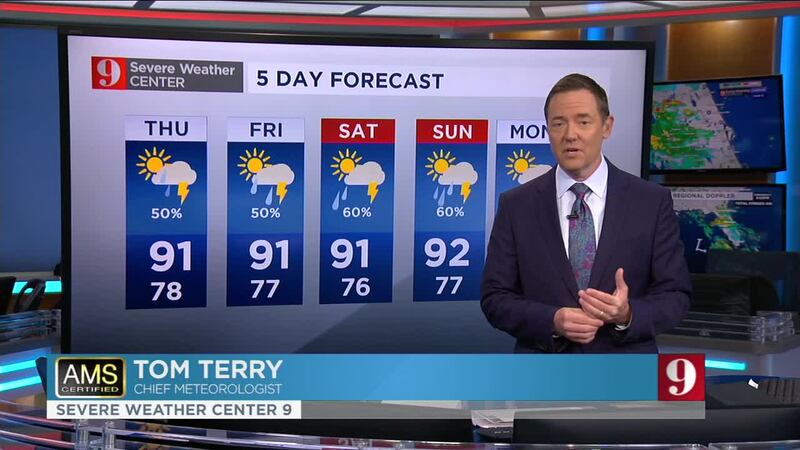
Watch your 5-day forecast below:
Entérese de todo lo que ocurre en el trópico en nuestra pagina en español.
Follow our Severe Weather team on Twitter for live updates:
- Chief meteorologist Tom Terry
- Brian Shields
- Irene Sans
- Kassandra Crimi
- George Waldenberger
- Rusty McCranie
© 2020 Cox Media Group


