
LIVE RADAR: Track thunderstorms live here
ORLANDO, Fla. — 6:30 p.m. update:
Storms will end shortly after sunset. Temperatures will be in the upper-70s.
The storms will continue into weekend, mainly focused during the afternoon hours.
We continue to monitor very closely Tropical Storm Laura and the tropical system located in the western Caribbean.
See the laster on Eye on the Tropics
4 p.m. update:
Severe thunderstorms affect parts of Seminole, Lake, Orange, Volusia Counties. The storm located near Lake Mary is moving northeast at about 20 mph. Damaging wind gusts above 60 mph are possible and there could be some rotation. Nickel size hail is also possible. If you are in, or near, the following areas, please stay indoors: Deltona, Sanford, Apopka, Altamonte Springs, and Oviedo.
Severe Thunderstorm Warning
— Irene Sans (@IreneSans) August 21, 2020
Stay indoors! 60mph gusts & hail possible. Stay away from windows. Read more> https://t.co/PAh1UtzTG8
Aviso por tormenta severa. Ráfagas de +60mph y granizo son posibles. Quédese bajo techo, manténgase alejado de ventanas. #StormAlert9 pic.twitter.com/DApxcH5c5m
Early version:
There will be more storms in Central Florida this afternoon. Once again, the weather will remain unstable for Friday afternoon. Some storms could once again turn severe in the afternoon hours after the sea breeze develops.
There could be flooding developing over areas were the storms become more persistent, make sure to take an alternate route if you encounter one on the road. Lightning and strong gusts are also likely with Friday’s storms.
Highs will reach the low 90s, but it will feel as if temperatures were in the upper-90s.
Did you know? Red skies are a sailor’s delight… except when a slow-moving tropical storm is near
DOWNLOAD: WFTV Free Weather App to get alerts for your location
Visite la sección en español: Temporada de huracanes
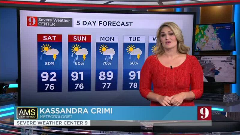
5-day forecast:
Follow our Severe Weather team on Twitter for live updates:
- Chief meteorologist Tom Terry
- Brian Shields
- Irene Sans
- Kassandra Crimi
- George Waldenberger
- Rusty McCranie
© 2020 Cox Media Group


