Tropical Storm Humberto continues to organize and continues to move away from the Bahamas.
The National Hurricane Center said Humberto strengthened to 60 mph winds and is expected to become a hurricane Sunday.
Even though Humberto is staying well off Florida's coast, we're still feeling some of the outlying effects in Central Florida.
Despite dry air on the south side of Humberto, it's strengthening tonight. #EyeOnTheTropics #WFTV #FLwx #Florida #Humberto pic.twitter.com/IrInxuz0FG
— George Waldenberger (@GWaldenWFTV) September 15, 2019
11pm update: Tropical Storm Humberto strengthening, winds to 60mph, expected to become a hurricane Sunday. #WFTV #FLwx #Florida #EyeOnTheTropics pic.twitter.com/aU3gDc14t0
— George Waldenberger (@GWaldenWFTV) September 15, 2019
Download the WFTV weather app | Hour-by-hour in your city
Humberto is now making a more northward progression and is gradually moving away from the Bahamas. It is moving north-northwest at 7 mph, Waldenberger said.
"Humberto is forecast to stay off our coast by roughly 150 miles, passing at its closest point Sunday afternoon," Waldenberger said. "Our outlying impacts continue to be rough surf and rip currents at our beaches, breezy weather and quick, passing showers through tomorrow."
Humberto is forecast to strengthen into a hurricane by Monday as it begins turning much farther out to sea.
5pm Tropical Storm Humberto track update...forecast to strengthen to a hurricane tomorrow night or Monday due to warm waters and lower wind shear ahead. #WFTV #FLwx #EyeOnTheTropics pic.twitter.com/4CSbfHHkBM
— George Waldenberger (@GWaldenWFTV) September 14, 2019
Tropical Storm Humberto to gradually move away from The Bahamas today and tonight, now moving northwest at 7mph. #WFTV #EyeOnTheTropics #WFTV pic.twitter.com/hRpBiGWHmP
— George Waldenberger (@GWaldenWFTV) September 14, 2019
As of 5 a.m., all of the tropical storm watches for Central Florida, both land and water, have been dropped.
Over the next couple of days, brief downpours will remain in the forecast, with breezy winds and northeast gusts of 10-20 mph inland and 15-25 mph at the coast.
Our seas will experience the greatest impacts, and dangerous boating conditions with small craft advisories will be in place.
There is also a high surf advisory in place, with waves expected to be 4-6 feet and a high risk of rip currents.
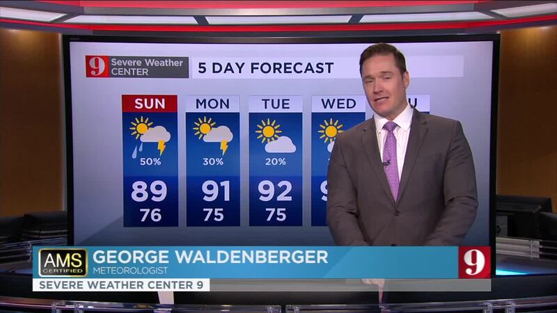
Check out your full five-day forecast below:
Follow our Severe Weather team on Twitter for live updates:
- Chief meteorologist Tom Terry
- Brian Shields
- Irene Sans
- Kassandra Crimi
- George Waldenberger
- Rusty McCranie

Cox Media Group


