
ORLANDO, Fla. — There are many unofficial hurricane seasons forecasts out there, but only a couple are reliable and based on factual meteorological and climatological data.
The hurricane season forecast from the National Weather Service is released during the month of May every year and it is updated in August.
COLORADO STATE UNIVERSITY: 37 YEARS OF HURRICANE SEASON FORECASTS
Colorado State University also releases a hurricane season forecast. This university has been known for its great meteorology program and the hurricane forecast has been released every year since 1984 by the late Dr. William Gray. In the late 1970s, Gray found that hurricane activity is cyclical and his forecasts (as well as his great sense of humor) have been well known in the meteorology field. Gray died in 2016.
Dr. Phil Klotzbach, who worked with Gray for many years, has continued releasing the renowned hurricane season forecasts and their updates. Colorado State’s hurricane season forecast is released in April every year and then updated a couple of times through the season.
Read: Saharan Dust coming to Central Florida: What is it? What does it do?
Video: How does a tropical system form?
En español: ¿Cómo se forma un sistema tropical?
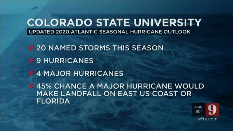
COLORADO STATE’S 2020 HURRICANE SEASON FORECAST
The forecast called for an active season in the April release, with 16 named storms. The forecast was updated to 20 named storms on Tuesday. This forecast includes the five storms that have already formed.
Out of the 20 named storms, nine would become hurricanes. And out of these nine, there would be four major hurricanes. The full season average is 12 named storms: six hurricanes and three major hurricanes.
Klotzbach’s hurricane season forecast also shows the probability of a storm impacting the entire continental U.S. coastline, the U.S. East Coast, and the Gulf Coast states.
READ: What’s the difference: Disturbance, depressions, tropical, subtropical storms, hurricanes
For this year, there is a 69% chance of at least one major hurricane striking the entire continental U.S. coastline, 45% chance of at least a major hurricane striking the East Coast, including the Florida peninsula and a 44 % of at least one major hurricane striking the Gulf Coast states westward to Brownsville. These percentages are above average for the last century. Averages for the last century are 52%, 31%, and 30%, respectively.
There is also a forecast for at least one major hurricane tracking into the Caribbean. There is a 58% chance of this occurring during the 2020 hurricane season. The average for the last century is 42%.
DOWNLOAD OUR FREE WFTV WEATHER APP TO RECEIVE ALERTS
Read: NOAA Forecasters highly confident about an active 2020 Hurricane Season
Nota en español: Temporada de Huracanes 2020: Pronosticadores altamente confiados en una temporada activa
WHY SO ACTIVE?
This season calls for above-average activity, . The average is taken from the 1981-2010 years. This year is showing signs that there will be either cool neutral ENSO or a weak La Niña conditions forming during the rest of the summer and into the fall season since the eastern and tropical Pacific waters are slightly cooler than average. La Niña conditions suppress tropical activity over the Pacific but enhance tropical activity over the Atlantic Basin.
The Atlantic waters continue to be above average for this season, and Klotzbach has noticed that, specifically over the eastern Atlantic where there are anomalously warm temperatures in June, there have been more active hurricane seasons.
As we constantly remind WFTV readers and viewers, the time to prepare is now. Have a plan ready. It only takes one storm to make it an active season for you.
Entérese del pronóstico del tiempo, en español, por nuestra meteoróloga Irene Sans
Follow our Severe Weather team on Twitter for live updates:
- Chief meteorologist Tom Terry
- Brian Shields
- Irene Sans
- Kassandra Crimi
- George Waldenberger
- Rusty McCranie
© 2020 Cox Media Group


