
ORLANDO, Fla. — >> CLICK HERE FOR LIVE DOPPLER 9 RADAR <<
Temperatures will remain hot throughout Central Florida and storm chance will gradually increase.
Here’s what you can expect:
- Temperatures reached the mid-to-upper-90s Tuesday afternoon, but they will felt as if they were between 100 to 105 degrees.
- Isolated storms affect our area, from west to east.
- Storm chance will gradually increase by the end of the week and with a slightly higher chance for showers, temperatures will be less warm.
Central Florida: Yesterday #Sanford tied a record (98)... today, the story repeats.. 99 degrees at Sanford. More heat tomorrow, storm chance increases the rest of the week, and with this, less warm (but still hot!) pic.twitter.com/djKNTSwXzy
— Irene Sans (@IreneSans) June 30, 2020
OH, CENTRAL FLORIDA! Rainbow, lightning bolt recorded over Ormond Beach neighborhood
>> WATCH OUR NEWSCAST LIVE HERE <<
PHOTOS: Saharan dust seen from Central Florida and parts of the Caribbean, gorgeous sunrises and sunsets!
Read: Saharan dust in Central Florida: What is it? What does it do?
Make sure to always have at least three ways of receiving weather alerts. You can download our Free WFTV Weather App (make sure to allow notifications) to receive alerts wherever you are located.
DOWNLOAD OUR FREE WFTV WEATHER APP TO RECEIVE ALERTS
Read: Forecasters highly confident about an active 2020 Hurricane Season
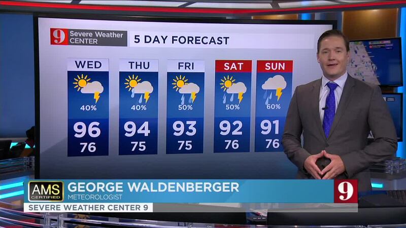
Watch your 5-day forecast below:
Entérese de todo lo que ocurre en el trópico en nuestra pagina en español.
Follow our Severe Weather team on Twitter for live updates:
- Chief meteorologist Tom Terry
- Brian Shields
- Irene Sans
- Kassandra Crimi
- George Waldenberger
- Rusty McCranie
© 2020 Cox Media Group


