
ORLANDO, Fla. — >> CLICK HERE FOR LIVE DOPPLER 9 RADAR <<
11:00 p.m.
More damage is reported across Orange County. Surfboards landed broken after being flown by strong winds.
The National Weather Service will survey damages on Sunday, if weather allows.
A tornado rolled through Orlando today...here's the video. Credit: Will Calder. pic.twitter.com/Xxp3J7dSVo
— George Waldenberger (@GWaldenWFTV) June 7, 2020
SEE: Severe storms, possible tornado cause damage across Orlando
Weather-permitting, @NWSMelbourne plans to survey damage in Orlando Sunday morning. Tornado already confirmed from numerous video and reports. Will determine strength and beginning/ending locations/times while on scene. @orloem
— Scott Spratt (@mlbwcm) June 7, 2020
10:00 p.m. update
Strong storms are starting to wind down across Central Florida. The line of storms that extended from Osceola through Orange, Seminole, Lake, and Volusia is simmering down as it continues to move northeast.
Conditions seem to become calmer, just showers streaming over Central Florida, but they are not expected to be as strong as the ones just passed during the late afternoon and early evening.
There could be embedded storms, but they will be very isolated overnight.
For Sunday, expect another round of storms as the rainbands of storms from Tropical Storm Cristobal, which is expected to make landfall late Sunday in Louisiana.
SEE: Severe storms, possible tornado cause damage across Orlando
9:15 p.m. update
Damaging winds extending from a long rainband moving over Osceola County through Orange, Seminole and Lake. The line of storm could have embedded rotation in it, therefore there is a broad tornado warning over northern Lake County which will expire at 9:45 p.m.
Another tornado warning for Seminole County will expire at 9:30 p.m.
Very strong winds coming to the following cities within the next 30 minutes. Lightning & thunder is building. STAY INDOORS #Stormalert9 @WFTV pic.twitter.com/6xv2m98iIz
— Irene Sans (@IreneSans) June 7, 2020
8:45p.m. update
Damaging winds coming to the Downtown Area and nearby communities again. This area has reported trees down, damage in houses, and thousands without power. Stay indoors.
<<CLICK HERE FOR LIVE COVERAGE>>
Tornado warning for #Orange. Southwest of Downtown to Downtown: #Tornadoes And Extensive Straight Line Wind Damage Were Located Over Horizon West, Or Over Bay Lake, Moving northeast At 40 Mph. @citybeautiful pic.twitter.com/zGqeWNC7VP
— Irene Sans (@IreneSans) June 7, 2020
8:15 p.m. update
Tornado warning issued for Seminole County. The warning will expire at 8:45 p.m.
Tornado Warning including Deltona FL, Sanford FL, DeBary FL until 8:45 PM EDT pic.twitter.com/MLBADj2dku
— NWS Tornado (@NWStornado) June 7, 2020
8:06 p.m. update
A tornado warning was issued for Volusia until 8:30 p.m.
Tornado Warning continues for DeLand FL, De Leon Springs FL until 8:30 PM EDT pic.twitter.com/M3Ykgx7FNt
— NWS Tornado (@NWStornado) June 7, 2020
A tornado warning for Orange County, specifically for the east of downtown Orlando until 8 p.m.
A tornado warning has been issued for Downtown Orlando. Take cover now if you are Downtown to Winter Park. We are live on @wftv channel 9 https://t.co/Ir4flGbDge
— Irene Sans (@IreneSans) June 6, 2020
El radar detecta rotación just al sur del Downtown de Orlando. Si esta en el Centro de la Ciudad hasta Winter Park, vaya a su refugio ahora. Póngase los zapatos. Estamos en vivo https://t.co/5XNsEaZEnJ https://t.co/Ir4flGbDge
— Irene Sans (@IreneSans) June 6, 2020
Funnel cloud video
The tornado warned storm that happened just before 6 p.m. Saturday to the southwest of Downtown Orlando spun a funnel cloud near the Doctor Phillips area. Channel 9 viewers sent pictures and videos using #StormAlert9.
Video/pic was taken on the turnpike near Turkey Lake Service Plaza. This was the tornado warned area.
— Irene Sans (@IreneSans) June 6, 2020
Miren el video/foto, fue tomado desde la Turnpike cerca de la plaza de servicio Turkey Lake. Esta fue la tormenta por la cual se emitió un aviso de tornado. @saynotoheteros pic.twitter.com/iSD5rVtfaA
If you have pictures, taken safely, that you would like to share with us, you may do so by using #StormAlert9 on social media, or send them here
SHARE IMAGES AND PICTURES OF WEATHER WITH US
Tornado warning expires for Orange County
6:47 p.m. update
A tornado warning has expired for Orange County.
Tornado warning for Polk County expires
5:45 p.m. update
A tornado warning for Polk County has expired.
Tornado warning issued for Orange County
5:40 p.m. update
A tornado warning has been issued for Doctor Phillips, Windermere and Tangelo Park.
<<CLICK HERE FOR LIVE COVERAGE>>
Tornado Warning including Doctor Phillips FL, Windermere FL, Tangelo Park FL until 6:15 PM EDT pic.twitter.com/hZyfbnN3LU
— NWS Tornado (@NWStornado) June 6, 2020
Tornado warning issued for Polk County
>> CLICK HERE FOR LIVE DOPPLER 9 RADAR <<
5:35 p.m. update
A tornado warning has been issued for Polk County. The warning is set to expire at 6 p.m.
Tornado Warning including Polk County, FL until 6:00 PM EDT pic.twitter.com/FHgnMTuEa2
— NWS Tornado (@NWStornado) June 6, 2020
Tornado warning for Volusia County expires
4:32 p.m. update
A tornado warning for Volusia County has expired.
Tornado warning issued for Volusia County
SHARE IMAGES AND PICTURES OF WEATHER WITH US
4:22 p.m. update
A tornado warning has been issued for the Pierson, Barberville and Eldridge areas.
Tornado Warning continues for Pierson FL, Barberville FL, Eldridge FL until 4:30 PM EDT pic.twitter.com/V8P3l7NKrf
— NWS Tornado (@NWStornado) June 6, 2020
Tornado warning issued for Marion County
4:08 p.m. update
A tornado warning has been issued for the Belleview, Summerfield and Santos areas.
Tornado Warning including Belleview FL, Summerfield FL, Santos FL until 4:45 PM EDT pic.twitter.com/YJRkwdIVNU
— NWS Tornado (@NWStornado) June 6, 2020
Tornado warning issued for Sumter County
3:50 p.m. update
A tornado warning has been issued for Sumter County until 4 p.m., according to the National Weather Service.
Tornado Warning continues for Sumter County, FL until 4:00 PM EDT pic.twitter.com/W8JUby37rK
— NWS Tornado (@NWStornado) June 6, 2020
Tornado Warning 6/06 4:00PM Take action now if you are in shaded area.
— Irene Sans (@IreneSans) June 6, 2020
A tornado has been detected either by radar or visually. Go to the lowest, most central room in your location, away from windows. If one is near, put a helmet on. #StormAlert9 pic.twitter.com/Qg81aI7gPa
>> CLICK HERE FOR LIVE DOPPLER 9 RADAR <<
Original report:
It’s going to be a soggy Saturday in Central Florida as tropical moisture moves through the area.
“Rich tropical moisture will continue to stream into the area on and off. We’re just going to see some showers from time-to-time, especially in the afternoon hours,” meteorologist Rusty McCranie said.
SHARE IMAGES AND PICTURES OF WEATHER WITH US
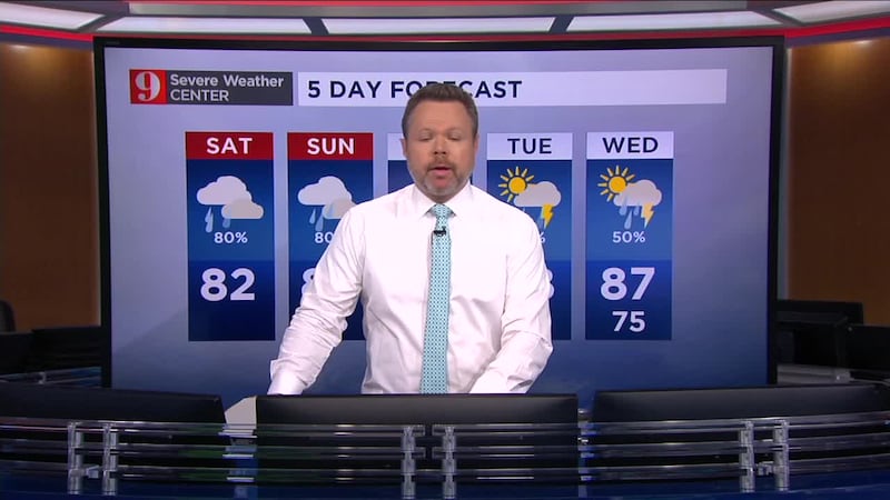
There’s an 80% chance of rain, with a daytime high of 82 for Saturday.
Read: Large asteroid to fly past Earth June 6
A flood watch is in effect for most of Central Florida, McCranie said.
Rain continues to move in this morning as we stay on the wet side of Tropical Storm Cristobal. At times, the rain will be very light, but tropical downpours will also develop and as wet as it has been, minor flooding of low-lying areas is possible. pic.twitter.com/aO6EnVAQQ0
— Rusty McCranie (@RMcCranieWFTV) June 6, 2020
“We could get some localized flooding in some low-lying areas if we get enough rain," he said.
SHARE IMAGES AND PICTURES OF WEATHER WITH US
The rain will stick around throughout the weekend, with an 80% chance of showers for Sunday.
A Flood Watch is in effect for a good part of Central Florida, including the Orlando metro area, all the way until Sunday night. Rainfall totals of 3-6" are likely in spots, and minor flooding of low-lying areas is possible. pic.twitter.com/Gj0MJ8DHDw
— Rusty McCranie (@RMcCranieWFTV) June 5, 2020
DOWNLOAD OUR FREE WFTV WEATHER APP TO RECEIVE ALERTS
Watch your 5-day forecast below:
Follow our Severe Weather team on Twitter for live updates:
- Chief meteorologist Tom Terry
- Brian Shields
- Irene Sans
- Kassandra Crimi
- George Waldenberger
- Rusty McCranie
© 2020 Cox Media Group


