Storms have slowly moved away from Central Florida, toward South Florida. Showers are slowly decreasing in coverage, but there is the chance of another, much weaker impulse to cross Central Florida during the evening hours. This last batch is not expected to bring severe weather, but there could be some pockets of very light showers.
More light/moderate rain is forming and will bring another wet mid to late evening and keep showers through 5am Wednesday morning. pic.twitter.com/4T8Hhdvzmr
— tom terry (@TTerryWFTV) April 10, 2018
Conditions will slowly improve through the early morning hours Wednesday.
Did you know?
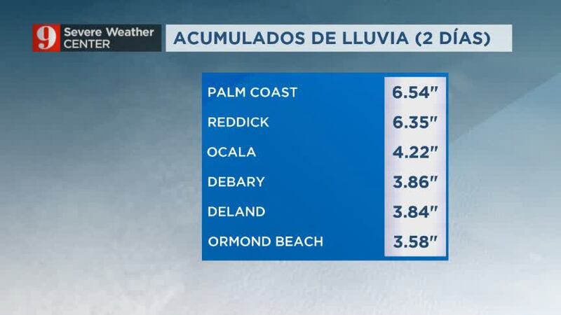
— George Waldenberger (@GWaldenWFTV) April 10, 2018
Today's rainfall totals at #Orlando Int'l #Airport are the highest since last September!#WFTV #Florida @MCO pic.twitter.com/LpHA69avZN
Temperatures will drop to the low-60s Wednesday morning, by the afternoon temperatures will reach the upper-70s to low-80s. This cool-down will be short-lived and temperatures will rebound to the mid-80s by Friday.
The rainfall will benefit the region as most of Orange and Osceola counties are under a moderate drought, and Brevard, Volusia and Flagler counties are under an abnormal drought.
We. Need. The. Rain. #drought
— Irene Sans (@IreneSans) April 9, 2018
65.91% of Florida is abnormally dry.
25.71 is under a moderate drought, mostly focused over South and Central Florida pic.twitter.com/RAq4DnxaZM

Watch video of flooding on South Orlando Avenue in Winter Park below:
Cox Media Group