The active weather pattern continues across Florida. A front combined with a trough in the middle levels of the atmosphere could spark a few strong to severe thunderstorms Tuesday afternoon.
There is still a chance for isolated showers Tuesday evening, but the pattern will become more stable. The front will not bring a relief to the heat,temperatures for the rest of the work-week will stay 5 to 8 degrees above average for this time of the year.
ORLANDO, Fla. — 4:30 p.m. update:
Strong winds swept across Orange and Seminole Co. knocking a tree down and powerlines in Oviedo. The severe storms moved over Seminole rushign eastward producing small hail near New Smyrna Beach.
As of 4:30 p.m. there are no warnings active, but there is still a chance for some storms to develop within the next couple hours. Storms will be isolated and become less intense once sun sets. There could still be some lingering showers overnight.
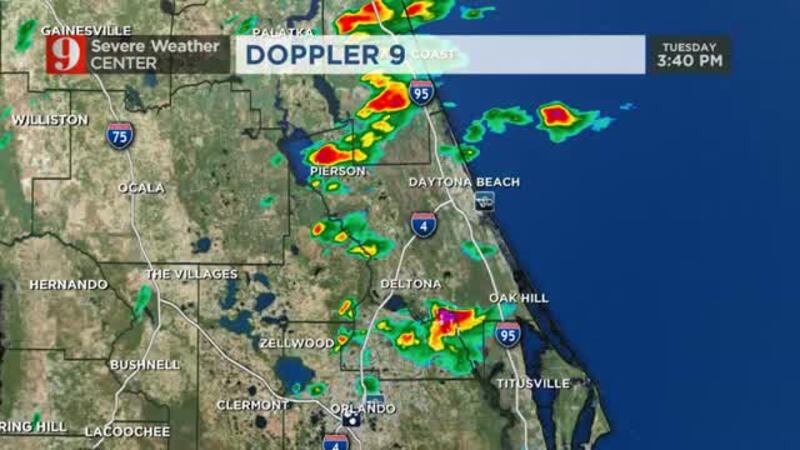
Severe storms pick up in Central Florida; rain lingers tonight Severe storms could produce damaging winds, hail and the risk for isolated tornadoes
3 p.m. update:
Dime size hail fell in College Park shortly before 3 p.m. Tuesday afternoon as storms start to develop and fill in the radar.
More storms are in the forecast through the afternoon. Strong gusts of more than 40 mph and hail will likely be produced by the storms. Make sure to drive safely and take your time on the roads.
Noon update:
The factor that could hinder the development of strong storms are the clouds, which are keeping the temperatures from rising and allowing the atmosphere to become more unstable. Clouds are mainly over the coast, but inland, the sun has peeked since before noon.
As the front approaches Central Florida, some storms have already started to develop over Marion County just before noon.
If you have seen the sun peek, there are more chances of strong storms to develop. Overall, Central Florida has remained under a thick layer of clouds. Highs will only reach the low 80s courtesy of the clouds.
Showers and storms will develop ahead of the frontal passage. First, storms will move from west to east, ahead of the front, as the winds shift from the west-southwest. As the front gets closer, the storms will move to the south-southeast through the afternoon. By 5 p.m., the storms should be along the coast of Brevard County.
Most of Central Florida will have measurable rain Tuesday and about 60 percent of the area will get storms.
THREATS
Flooding: some persistent storms could produce 1 – 2 inches of rain for some locations. Generally, Central Florida will receive between a half to 1 inch of rain Tuesday.
Hail: There is the potential for hail to develop with the strongest cells this afternoon. If possible, make sure to keep your car parked under a roof.
Damaging winds: Storms could produce strong wind gusts of more than 50 mph this afternoon. Winds could break branches and knock down weak trees.
All storms have lightning, but the storms today will likely have frequent and excessive lightning. Remember, if you hear thunder you are close enough to get struck by it.
Tornadoes: there is a chance for an isolated tornado to develop with this afternoon's weather setup. Make sure to stay weather aware and know where you'd take shelter in case of a tornado warning. If a tornado warning is issued for your location, head to the lowest level of you location, in the most central room, away from doors and windows.
Bee advised: Warm weather, blooming flowers cause early start to swarm season
2018 records: 4th warmest globally; Orlando also ties in top spot
BEYOND TUESDAY'S STORMS
There is still a chance for isolated showers Tuesday evening, but the pattern will become more stable. The front will not bring a relief to the heat, as a high-pressure system will settle in from the Gulf of Mexico, moderating the temperatures and keeping them between 5-8 degrees above average for this time of the year.
The sunshine will prevail through the end of the work week. Clouds will gradually increase during the weekend with the highest chance for rain returning on Sunday. We will continue to monitor the next storm system, fine tune the timing and bring you the latest on Eyewitness News, wftv.com, and on our free WFTV Weather app.
Winds along the east central coast of Florida
Check the water temperatures
Watch the 5-Day forecast below:
Follow the team from Severe Weather Center 9:
Cox Media Group