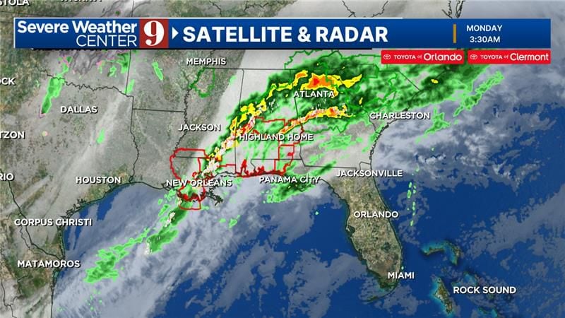
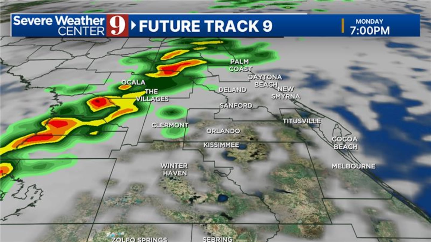
Several storms are approaching and should pass through the area Monday evening, certified meteorologist George Waldenberger said.
“Scattered, brief showers and even thunderstorms are possible briefly in most areas after sunset,” he said. “Then a cold front passes and cools us down for tomorrow.”
Atmospheric river hits California, brings heavy rain, wind Sand blows as as a powerful long-duration atmospheric river storm, the second in less than a week, impacts California on February 4, 2024 in Santa Barbara, California. The storm is delivering potential for widespread flooding, landslides and power outages while dropping heavy rain and snow across the region. (Mario Tama/Getty Images)
Atmospheric river hits California, brings heavy rain, wind Residents stand along a flooded street as a powerful long-duration atmospheric river storm, the second in less than a week, impacts California on February 4, 2024 in Santa Barbara, California. The storm is delivering potential for widespread flooding, landslides and power outages while dropping heavy rain and snow across the region. (Mario Tama/Getty Images)
Atmospheric river hits California, brings heavy rain, wind Nate Stephenson takes photos of a boat which washed ashore as a powerful long-duration atmospheric river storm, the second in less than a week, impacts California on February 4, 2024 in Santa Barbara, California. The storm is delivering potential for widespread flooding, landslides and power outages while dropping heavy rain and snow across the region. (Mario Tama/Getty Images)
Atmospheric river hits California, brings heavy rain, wind Storm damage from mud, rock and debris flows along Lockridge road in Studio City, California, has caused major damage to vehicles and houses in the area on Monday, February 5, 2024. Rain is expected to continue in Southern California over the next 12 hours. (David Crane/MediaNews Group/Los Angeles Daily News via Getty Images)
Atmospheric river hits California, brings heavy rain, wind A person walks along a flooded street as a powerful long-duration atmospheric river storm, the second in less than a week, impacts California on February 4, 2024 in Santa Barbara, California. The storm is delivering potential for widespread flooding, landslides and power outages while dropping heavy rain and snow across the region. (Mario Tama/Getty Images)
Atmospheric river hits California, brings heavy rain, wind People prepare sandbags at a sandbag station in preparation for flooding as a powerful long-duration atmospheric river storm, the second in less than a week, impacts California on February 4, 2024 in Santa Barbara, California. The storm is delivering potential for widespread flooding, landslides and power outages while dropping heavy rain and snow across the region. (Mario Tama/Getty Images)
Atmospheric river hits California, brings heavy rain, wind People gather along a flooded street as a powerful long-duration atmospheric river storm, the second in less than a week, impacts California on February 4, 2024 in Santa Barbara, California. The storm is delivering potential for widespread flooding, landslides and power outages while dropping heavy rain and snow across the region. (Mario Tama/Getty Images)
Atmospheric river hits California, brings heavy rain, wind A wave hits a boat which washed ashore as a powerful long-duration atmospheric river storm, the second in less than a week, impacts California on February 4, 2024 in Santa Barbara, California. The storm is delivering potential for widespread flooding, landslides and power outages while dropping heavy rain and snow across the region. (Mario Tama/Getty Images)
Atmospheric river hits California, brings heavy rain, wind Storm damage from mud, rock and debris flows along Lockridge road in Studio City, California, has caused major damage to vehicles and houses in the area on Monday, February 5, 2024. Rain is expected to continue in Southern California over the next 12 hours. (David Crane/MediaNews Group/Los Angeles Daily News via Getty Images)
Atmospheric river hits California, brings heavy rain, wind A person stands near a boat which washed ashore as a powerful long-duration atmospheric river storm, the second in less than a week, impacts California on February 4, 2024 in Santa Barbara, California. The storm is delivering potential for widespread flooding, landslides and power outages while dropping heavy rain and snow across the region. (Mario Tama/Getty Images)
Atmospheric river hits California, brings heavy rain, wind Storm damage from mud, rock and debris flows along Lockridge road in Studio City, California, has caused major damage to vehicles and houses in the area on Monday, February 5, 2024. Rain is expected to continue in Southern California over the next 12 hours. (David Crane/MediaNews Group/Los Angeles Daily News via Getty Images)
Atmospheric river hits California, brings heavy rain, wind A person walks along a flooded street as a powerful long-duration atmospheric river storm, the second in less than a week, impacts California on February 4, 2024 in Santa Barbara, California. The storm is delivering potential for widespread flooding, landslides and power outages while dropping heavy rain and snow across the region. (Mario Tama/Getty Images)
Atmospheric river hits California, brings heavy rain, wind A person shovels at a sandbag station in preparation for flooding as a powerful long-duration atmospheric river storm, the second in less than a week, impacts California on February 4, 2024 in Santa Barbara, California. The storm is delivering potential for widespread flooding, landslides and power outages while dropping heavy rain and snow across the region. (Mario Tama/Getty Images)
Atmospheric river hits California, brings heavy rain, wind People view the Los Angeles River swollen by storm runoff as a powerful long-duration atmospheric river storm, the second in less than a week, continues to impact Southern California on February 5, 2024 in Los Angeles, California. Nearly seven inches of rain have fallen in downtown Los Angeles during the storm, about half the average yearly total. The storm is delivering widespread flooding, landslides and power outages while dropping heavy rain and snow across the region. (Mario Tama/Getty Images)
Atmospheric river hits California, brings heavy rain, wind Firefighters gather near a mudslide as a powerful long-duration atmospheric river storm, the second in less than a week, continues to impact Southern California on February 5, 2024 in Beverly Hills, California. The storm is delivering widespread flooding, landslides and power outages while dropping heavy rain and snow across the region. (Mario Tama/Getty Images)
Atmospheric river hits California, brings heavy rain, wind Gas workers make repairs near a mudslide which destroyed a home as a powerful long-duration atmospheric river storm, the second in less than a week, continues to impact Southern California on February 5, 2024 in Los Angeles, California. Nearly seven inches of rain have fallen in downtown Los Angeles during the storm, about half the average yearly total. The storm is delivering widespread flooding, landslides and power outages while dropping heavy rain and snow across the region. (Mario Tama/Getty Images)
Atmospheric river hits California, brings heavy rain, wind People take photos of vehicles damaged by flooding as a powerful long-duration atmospheric river storm, the second in less than a week, continues to impact Southern California on February 5, 2024 near Malibu, California. The storm is delivering widespread flooding, landslides and power outages while dropping heavy rain and snow across the region. (Mario Tama/Getty Images)
Atmospheric river hits California, brings heavy rain, wind A view of mudslide damage which destroyed a home as a powerful long-duration atmospheric river storm, the second in less than a week, continues to impact Southern California on February 5, 2024 in Los Angeles, California. Nearly seven inches of rain have fallen in downtown Los Angeles during the storm, about half the average yearly total. The storm is delivering widespread flooding, landslides and power outages while dropping heavy rain and snow across the region. (Mario Tama/Getty Images)
Atmospheric river hits California, brings heavy rain, wind A person attempts to clear away debris from a mudslide as a powerful long-duration atmospheric river storm, the second in less than a week, continues to impact Southern California on February 5, 2024 in Beverly Hills, California. The storm is delivering widespread flooding, landslides and power outages while dropping heavy rain and snow across the region. (Mario Tama/Getty Images)
Atmospheric river hits California, brings heavy rain, wind A person views the damage of a home destroyed by a mudslide as a powerful long-duration atmospheric river storm, the second in less than a week, continues to impact Southern California on February 5, 2024 in Los Angeles, California. The storm is delivering widespread flooding, landslides and power outages while dropping heavy rain and snow across the region. (Mario Tama/Getty Images)
Atmospheric river hits California, brings heavy rain, wind An aerial view of the Los Angeles River swollen by storm runoff as a powerful long-duration atmospheric river storm, the second in less than a week, continues to impact Southern California on February 5, 2024 in Los Angeles, California. Nearly seven inches of rain have fallen in downtown Los Angeles during the storm, about half the average yearly total. The storm is delivering widespread flooding, landslides and power outages while dropping heavy rain and snow across the region. (Mario Tama/Getty Images)
Atmospheric river hits California, brings heavy rain, wind The Los Angeles River flows while swollen by storm runoff as a powerful long-duration atmospheric river storm, the second in less than a week, continues to impact Southern California on February 5, 2024 in Los Angeles, California. Nearly seven inches of rain have fallen in downtown Los Angeles during the storm, about half the average yearly total. The storm is delivering widespread flooding, landslides and power outages while dropping heavy rain and snow across the region. (Mario Tama/Getty Images)
Atmospheric river hits California, brings heavy rain, wind A view of mudslide damage which destroyed a home as a powerful long-duration atmospheric river storm, the second in less than a week, continues to impact Southern California on February 5, 2024 in Los Angeles, California. Nearly seven inches of rain have fallen in downtown Los Angeles during the storm, about half the average yearly total. The storm is delivering widespread flooding, landslides and power outages while dropping heavy rain and snow across the region. (Mario Tama/Getty Images)
Atmospheric river hits California, brings heavy rain, wind Workers shore up Pacific Ocean coastline next to homes as a powerful long-duration atmospheric river storm, the second in less than a week, continues to impact Southern California on February 5, 2024 near Malibu, California. The storm is delivering widespread flooding, landslides and power outages while dropping heavy rain and snow across the region. (Mario Tama/Getty Images)
Atmospheric river hits California, brings heavy rain, wind An aerial view of a home destroyed by a mudslide as a powerful long-duration atmospheric river storm, the second in less than a week, continues to impact Southern California on February 5, 2024 in Los Angeles, California. No one was in the home at the time. The storm is delivering widespread flooding, landslides and power outages while dropping heavy rain and snow across the region. (Mario Tama/Getty Images)
Atmospheric river hits California, brings heavy rain, wind A view of mudslide damage which destroyed a home as a powerful long-duration atmospheric river storm, the second in less than a week, continues to impact Southern California on February 5, 2024 in Los Angeles, California. Nearly seven inches of rain have fallen in downtown Los Angeles during the storm, about half the average yearly total. The storm is delivering widespread flooding, landslides and power outages while dropping heavy rain and snow across the region. (Mario Tama/Getty Images)
Atmospheric river hits California, brings heavy rain, wind People gather where a home was destroyed by a mudslide as a powerful long-duration atmospheric river storm, the second in less than a week, continues to impact Southern California on February 5, 2024 in Los Angeles, California. Nearly seven inches of rain have fallen in downtown Los Angeles during the storm, about half the average yearly total. The storm is delivering widespread flooding, landslides and power outages while dropping heavy rain and snow across the region. (Mario Tama/Getty Images)
Earlier story:
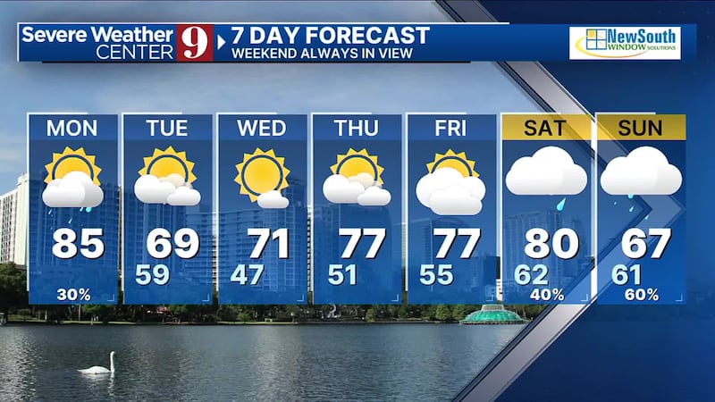
Front to bring showers and storms to Central Florida on Monday Central Florida will have another warm day Monday before a strong front brings big changes. (WFTV)
Central Florida will have another warm day Monday before a strong front brings big changes.
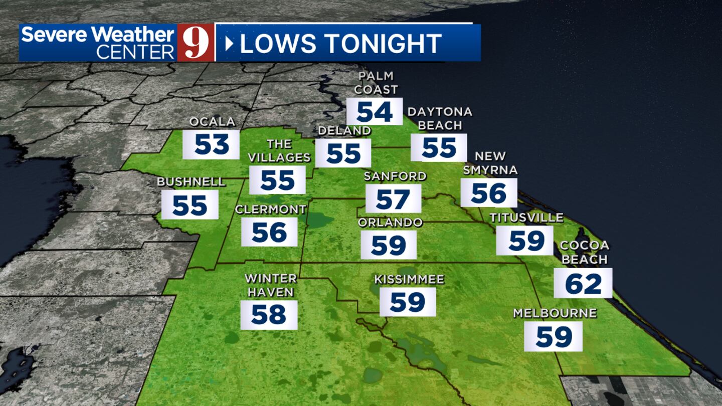
Our area will be very warm and windy Monday afternoon.