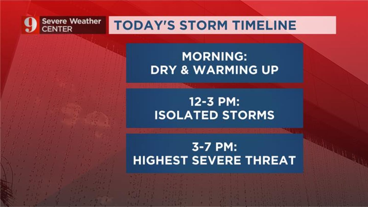
ORLANDO, Fla. — Wednesday is a Weather Alert Day in Central Florida with severe storms expected to move through this afternoon. See live updates below:
Central Middle School in West Melbourne shared photos of hail covering the campus courtyard.
5:45 p.m. update
Storms are currently dumping heavy rain in east Orange County, including the Christmas area.
5 p.m. update
Chief Meteorologist Tom Terry is tracking storms that are forecast to head into Clermont and Apopka. Storms are forecast to kick up in Orange and Lake counties starting closer to 6 p.m.
4:30 p.m. update
Chief meteorologist Tom Terry is tracking severe storms moving into Sanford and Seminole County.
Video: Weather Alert Day: Severe storms popping up across Central Florida Severe storms are popping up across Central Florida. (Tom Terry, WFTV.com)
Hail in Central Florida Channel 9 viewers submitted their photos of hail in Central Florida, which pounded areas like West Melbourne and Palm Bay on Wednesday. (WFTV)
Hail in Central Florida Channel 9 viewers submitted their photos of hail in Central Florida, which pounded areas like West Melbourne and Palm Bay on Wednesday. (WFTV)
Hail in Central Florida Channel 9 viewers submitted their photos of hail in Central Florida, which pounded areas like West Melbourne and Palm Bay on Wednesday. (WFTV)
Hail in Central Florida Channel 9 viewers submitted their photos of hail in Central Florida, which pounded areas like West Melbourne and Palm Bay on Wednesday. (WFTV)
Hail in Central Florida Channel 9 viewers submitted their photos of hail in Central Florida, which pounded areas like West Melbourne and Palm Bay on Wednesday. (WFTV)
Hail in Central Florida Channel 9 viewers submitted their photos of hail in Central Florida, which pounded areas like West Melbourne and Palm Bay on Wednesday. (WFTV)
Hail in Central Florida Channel 9 viewers submitted their photos of hail in Central Florida, which pounded areas like West Melbourne and Palm Bay on Wednesday. (WFTV)
Hail in Central Florida Channel 9 viewers submitted their photos of hail in Central Florida, which pounded areas like West Melbourne and Palm Bay on Wednesday. (WFTV)
Hail in Central Florida Channel 9 viewers submitted their photos of hail in Central Florida, which pounded areas like West Melbourne and Palm Bay on Wednesday. (WFTV)
Hail in Central Florida Channel 9 viewers submitted their photos of hail in Central Florida, which pounded areas like West Melbourne and Palm Bay on Wednesday. (WFTV)
Hail in Central Florida Channel 9 viewers submitted their photos of hail in Central Florida, which pounded areas like West Melbourne and Palm Bay on Wednesday. (WFTV)
Hail in Central Florida Channel 9 viewers submitted their photos of hail in Central Florida, which pounded areas like West Melbourne and Palm Bay on Wednesday. (WFTV)
Hail in Central Florida Channel 9 viewers submitted their photos of hail in Central Florida, which pounded areas like West Melbourne and Palm Bay on Wednesday. (WFTV)
Hail in Central Florida Channel 9 viewers submitted their photos of hail in Central Florida, which pounded areas like West Melbourne and Palm Bay on Wednesday. (WFTV)
Hail in Central Florida Channel 9 viewers submitted their photos of hail in Central Florida, which pounded areas like West Melbourne and Palm Bay on Wednesday. (WFTV)
Hail in Central Florida Channel 9 viewers submitted their photos of hail in Central Florida, which pounded areas like West Melbourne and Palm Bay on Wednesday. (WFTV)
Hail in Central Florida Channel 9 viewers submitted their photos of hail in Central Florida, which pounded areas like West Melbourne and Palm Bay on Wednesday. (WFTV)
Hail in Central Florida Channel 9 viewers submitted their photos of hail in Central Florida, which pounded areas like West Melbourne and Palm Bay on Wednesday. (WFTV)
Hail in Central Florida Channel 9 viewers submitted their photos of hail in Central Florida, which pounded areas like West Melbourne and Palm Bay on Wednesday. (WFTV)
Hail in Central Florida Channel 9 viewers submitted their photos of hail in Central Florida, which pounded areas like West Melbourne and Palm Bay on Wednesday. (WFTV)
Hail in Central Florida Channel 9 viewers submitted their photos of hail in Central Florida, which pounded areas like West Melbourne and Palm Bay on Wednesday. (WFTV)
Hail in Central Florida Channel 9 viewers submitted their photos of hail in Central Florida, which pounded areas like West Melbourne and Palm Bay on Wednesday. (WFTV)
Hail in Central Florida Channel 9 viewers submitted their photos of hail in Central Florida, which pounded areas like West Melbourne and Palm Bay on Wednesday. (WFTV)
Hail in Central Florida Channel 9 viewers submitted their photos of hail in Central Florida, which pounded areas like West Melbourne and Palm Bay on Wednesday. (WFTV)
Hail in Central Florida Channel 9 viewers submitted their photos of hail in Central Florida, which pounded areas like West Melbourne and Palm Bay on Wednesday. (WFTV)
Hail in Central Florida Channel 9 viewers submitted their photos of hail in Central Florida, which pounded areas like West Melbourne and Palm Bay on Wednesday. (WFTV)
Hail in Central Florida Channel 9 viewers submitted their photos of hail in Central Florida, which pounded areas like West Melbourne and Palm Bay on Wednesday. (WFTV)
Hail in Central Florida Channel 9 viewers submitted their photos of hail in Central Florida, which pounded areas like West Melbourne and Palm Bay on Wednesday. (WFTV)
Hail in Central Florida Channel 9 viewers submitted their photos of hail in Central Florida, which pounded areas like West Melbourne and Palm Bay on Wednesday. (WFTV)
Hail in Central Florida Channel 9 viewers submitted their photos of hail in Central Florida, which pounded areas like West Melbourne and Palm Bay on Wednesday. (WFTV)
Hail in Central Florida Channel 9 viewers submitted their photos of hail in Central Florida, which pounded areas like West Melbourne and Palm Bay on Wednesday. (WFTV)
Hail on I-95 Hail is falling on I-95 in Brevard County. (FDOT)
Hail in Central Florida Channel 9 viewers submitted their photos of hail in Central Florida, which pounded areas like West Melbourne and Palm Bay on Wednesday. (WFTV)
Hail in Central Florida Channel 9 viewers submitted their photos of hail in Central Florida, which pounded areas like West Melbourne and Palm Bay on Wednesday. (WFTV)
Hail in Central Florida Channel 9 viewers submitted their photos of hail in Central Florida, which pounded areas like West Melbourne and Palm Bay on Wednesday. (WFTV)
Hail in Central Florida Channel 9 viewers submitted their photos of hail in Central Florida, which pounded areas like West Melbourne and Palm Bay on Wednesday. (WFTV)
Hail in Central Florida Channel 9 viewers submitted their photos of hail in Central Florida, which pounded areas like West Melbourne and Palm Bay on Wednesday. (WFTV)
Hail in Central Florida Channel 9 viewers submitted their photos of hail in Central Florida, which pounded areas like West Melbourne and Palm Bay on Wednesday. (WFTV)
Hail in Central Florida Channel 9 viewers submitted their photos of hail in Central Florida, which pounded areas like West Melbourne and Palm Bay on Wednesday. (WFTV)
Hail in Central Florida Channel 9 viewers submitted their photos of hail in Central Florida, which pounded areas like West Melbourne and Palm Bay on Wednesday. (WFTV)
Hail in Central Florida Channel 9 viewers submitted their photos of hail in Central Florida, which pounded areas like West Melbourne and Palm Bay on Wednesday. (WFTV)
Hail in Central Florida Channel 9 viewers submitted their photos of hail in Central Florida, which pounded areas like West Melbourne and Palm Bay on Wednesday. (WFTV)
Hail in Central Florida Channel 9 viewers submitted their photos of hail in Central Florida, which pounded areas like West Melbourne and Palm Bay on Wednesday. (WFTV)
Hail in Central Florida Channel 9 viewers submitted their photos of hail in Central Florida, which pounded areas like West Melbourne and Palm Bay on Wednesday. (WFTV)
Hail in Central Florida Channel 9 viewers submitted their photos of hail in Central Florida, which pounded areas like West Melbourne and Palm Bay on Wednesday. (WFTV)
Hail in Central Florida Channel 9 viewers submitted their photos of hail in Central Florida, which pounded areas like West Melbourne and Palm Bay on Wednesday. (WFTV)
Hail in Central Florida Channel 9 viewers submitted their photos of hail in Central Florida, which pounded areas like West Melbourne and Palm Bay on Wednesday. (WFTV)
Hail in Brevard County (Burst)
Hail in Brevard County (Burst)
Hail in West Melbourne (ErinAlvarado94)
Brevard County hail (Burst)
Hail on I-95 Hail is falling on I-95 in Brevard County. (WFTV Staff)
Hail in West Melbourne (Burst)
Hail in West Melbourne (Burst)
Hail in West Melbourne (Burst)
Hail in West Melbourne (Burst)
Brevard County hail (Burst)
Hail on I-95 Hail is falling on I-95 in Brevard County. (FDOT)
Afternoon forecast: Wednesday, April 26 (WFTV)
2:30 p.m. update
Orlando International Airport said airline operations may be impacted today due to the forecasted severe weather. You can click here to track airport delays.
Weather Alert ⛈️ Due to thunderstorms throughout the day, airline ops may be impacted with flight delays/cancellations and baggage delivery delays. Please check with your airline directly for any updates regarding your flight. For airport delays, visit: https://t.co/vm0yMYHkcvhttps://t.co/DPILMPt8XE
A severe thunderstorm watch is in effect for all of Central Florida through 9 p.m.
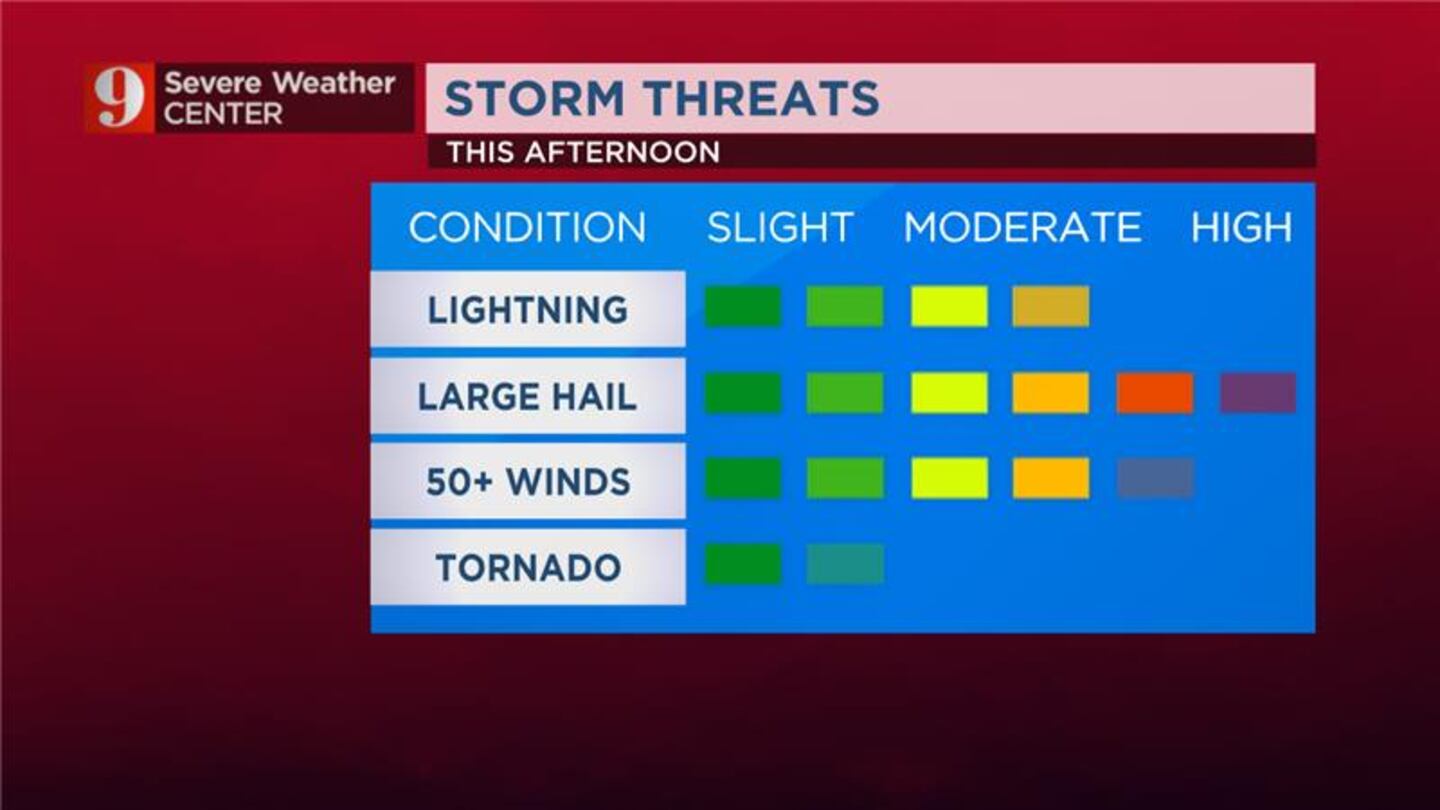
Chief meteorologist Tom Terry said extremely cold air in the mid/upper atmosphere will make for unusually large hail threat up to baseball size (again), and gusty winds over 60 mph. There will be an isolated tornado threat as well.
Channel 9 meteorologists will be tracking the storms all afternoon. Stay tuned to Eyewitness News and follow our Severe Weather team on Twitter for updates:
Weather Alert Day: Storm threats for Wednesday afternoon
DAMAGING HAIL POSSIBLE: It’s a Weather Alert Day for the higher chance of severe storms this afternoon. Large hail is likely in some of these storms. Not all of us have the option, but if you can, park in a garage/car port this afternoon. I’m tracking the storms on 9 now. pic.twitter.com/eCkgHvhxwK
Sarah Wilson joined WFTV Channel 9 in 2018 as a digital producer after working as an award-winning newspaper reporter for nearly a decade in various communities across Central Florida.