
Parts of Central Florida were drenched by heavy rain on Monday evening.
There was a 60% chance of rainstorms with an average high temperature of 94 degrees.
More than 2 inches of rain were reported in parts of Brevard County as heavy sea breeze storms returned Monday, chief meteorologist Tom Terry said.
"We'll see more afternoon storms through midweek, then an even higher chance for downpours (later in the) week as a weak front stalls in North Florida," he said. "Overall, a busy weather week."
Watch Live: Doppler 9 HD | Live updates on Eyewitness News
The evening will be partly cloudy and muggy with an average low temperature of 76 degrees.
Meanwhile, forecasters warn of dangerously hot weather across a stretch of Southern states and the Midwest.
The National Weather Service said areas of 13 states from Texas, Louisiana and Florida in the South to Missouri and Illinois in the Midwest will be under heat advisories Monday.
Know the difference: Heat exhaustion vs. Heatstroke
Marion and Flagler counties were under heat advisories.
The NWS said it will be even hotter across northwestern Mississippi, northern Louisiana and Arkansas, where the heat index could reach 115 degrees.
Remember to stay hydrated and wear sunscreen to protect yourself from heat exhaustion and heatstroke.
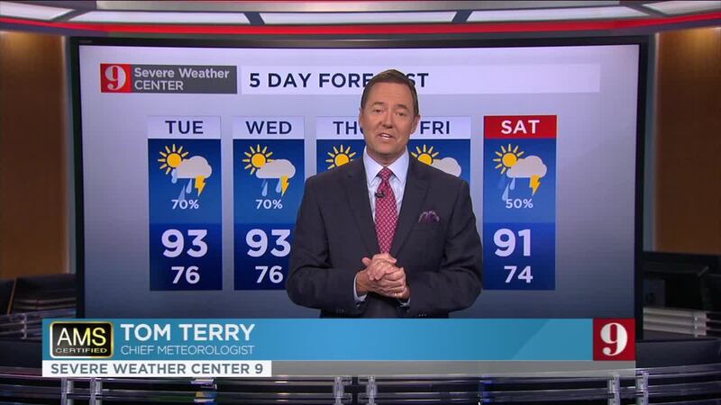
Watch your 5-Day forecast below:
Already nearly 3" of rain has fallen near Cocoa, and still raining heavily.
— tom terry (@TTerryWFTV) August 12, 2019
Advertencia por inundación. Zonas con mal drenaje pueden inundarse. Calles pueden estar inundadas, no intente cruzar. Tome vía alterna #stormalert9 pic.twitter.com/Gq27HR9bkp
Follow our Severe Weather team on Twitter for live updates:
- Chief meteorologist Tom Terry
- Brian Shields
- Irene Sans
- Kassandra Crimi
- George Waldenberger
- Rusty McCranie

Cox Media Group


