
ORLANDO, Fla. — >> CLICK HERE FOR LIVE DOPPLER 9 RADAR <<
>> WATCH OUR NEWSCAST LIVE HERE <<
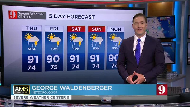
We are back into the typical summer pattern across Central Florida. Expect the hot and muggy conditions to persist, with the sea breezes developing and triggering storms as they move inland from both coasts.
Here’s what you can expect: Afternoon temps in the lower 90s.
- About 50 percent of Central Florida should receive measurable rain.
- Some of the storms could produce heavy rainfall.
- Storms will gradually cease after sunset.
Western Orange County, extreme northwestern Osceola under a flood advisory.
— Irene Sans (@IreneSans) June 10, 2020
1 to 2 inches of rain have fallen and another 1 to 2 inches are possible.
Stay away from flooded areas. #stomalert9 pic.twitter.com/WYUbuTvarz
Make sure to always have at least 3 ways of receiving weather alerts. You can download our Free WFTV Weather App (make sure to allow notifications) to receive alerts wherever you are located.
VIEWER PHOTOS: Tornado sightings and damage across Central Florida
Read more: Tornadic weekend for Central Florida: 3 tornadoes, one left a local family without a home
SEE pictures: Hole-punch clouds seen in Central Florida on November 2019
Watch your full 5 Day Forecast below:
DOWNLOAD OUR FREE WFTV WEATHER APP TO RECEIVE ALERTS
Read: Forecasters highly confident about an active 2020 Hurricane Season
Entérese del pronóstico del tiempo, en español, por nuestra meteoróloga Irene Sans:
Follow our Severe Weather team on Twitter for live updates:
- Chief meteorologist Tom Terry
- Brian Shields
- Irene Sans
- Kassandra Crimi
- George Waldenberger
- Rusty McCranie
© 2020 Cox Media Group


