>>Click here to watch our 24/7 Weather stream<<
Bookmark this page to get the latest updates on the storm’s track.
Blog en español: Aumentarán vientos, lluvias esta noche mientras que Isaías se acerca costa este de Florida
11:08 p.m. update:
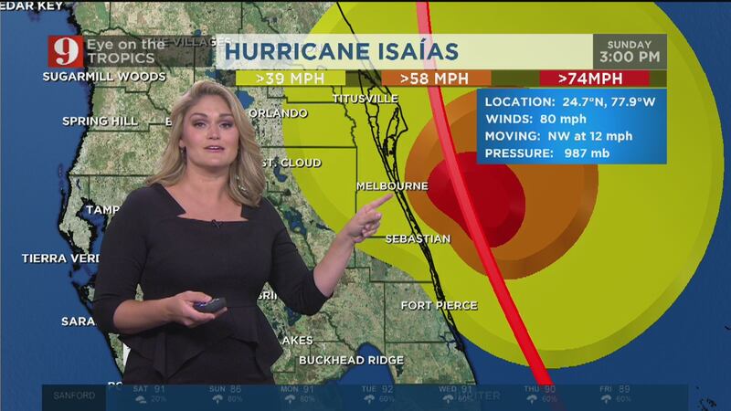
Tropical Storm Isaias continues slow track towards Florida’s east coast
ORLANDO, Fla. — Tropical Storm Isaias is continuing to move towards Florida’s east coast Saturday night.
Isaias still has 70 mph winds after being downgraded from a hurricane in the afternoon.
The storm is currently moving northwest at 9 mph.
Isaias is forecast to intensify slightly, enough to achieve hurricane status before passing along Central Florida’s coast Sunday evening.
New 11pm track update...Isaias still a tropical storm, winds at 70mph. Forecast to intensify slightly, enough to achieve hurricane status before passing along our coast tomorrow later in the day. #WFTV pic.twitter.com/a6Zda40BX5
— George Waldenberger (@GWaldenWFTV) August 2, 2020
9:50 p.m. update:
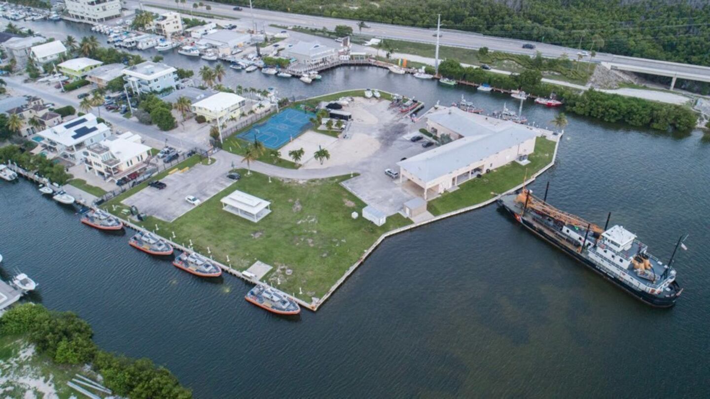
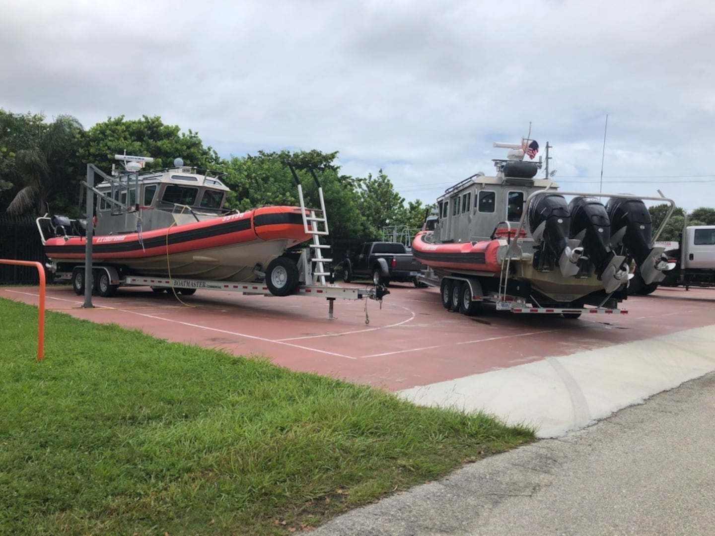
Coast Guard urges Isaias preparations, boaters asked to stay off water
Coast Guard officials continue to urge boaters to make preparations as Tropical Storm Isaias aims to impact Florida’s coastline over the weekend.
Officials said the Coast Guard has reduced capability to respond during major storms.
Hurricanes can bring potential hazards that include high surfs, dangerous rip currents, undertow conditions, heavy winds, heavy rainfall and coastal floodings.
The Coast Guard has several recommendations for the public to follow to be safe in a weather emergency. Stay off the water, evacuate as necessary, secure belongings, stay clear of beaches, be prepared and stay informed.
9 p.m. update:
Tom Terry breaks down timing, impacts of Isaias on Central Florida’s coast
Tom Terry gave a breakdown Saturday evening the watches and warning that have been issued for Tropical Storm Isaias.
#Isaias Brevard county impacts. #EyeonTropics @WFTV pic.twitter.com/PFHwzTIZQI
— Tom Terry (@TTerryWFTV) August 1, 2020
The storm is expected to strengthen back to a hurricane as is moves closer to Florida overnight.
#Isaias Volusia and Flagler county impacts. #EyeonTropics @WFTV pic.twitter.com/v6JW8Nn09K
— Tom Terry (@TTerryWFTV) August 1, 2020
>>Do you know your evacuation route? Click here to find it. <<
8 p.m. update:
Isaias slowing, trying to reorganize
Isaias is slowing down and it is now moving northwest at 9 mph, with winds still at 70 mph. Massive convection is flaring out as the storm attempts to reorganize.
The storm could reorganize and strengthen again to a category one hurricane by 11 p.m., but dry air and wind shear will continue to make the system struggle.
Sun 8PM: #Isaias slowing down a tad to NW at 9pm. Flare up of convection ongoing on N/NE quadrant, the system trying to get back together but dry air and some shear hampering. @WFTV pic.twitter.com/4ZSBkyNWeU
— Tom Terry (@TTerryWFTV) August 1, 2020
7:37 p.m. update:
Tropical storm force winds reported in Florida
Tropical storm force winds were reported in St. Lucie.
First of what will be many more tropical storm strength wind reports from #Isaias. pic.twitter.com/zGrdyAAlSz
— Tom Terry (@TTerryWFTV) August 1, 2020
Channel 9 has a team of reporters along the Florida coast.
Watch their live reports below:

6:15 p.m. update
Tropical storm force winds could be felt throughout Central Florida
Strong wind is one of the four main threats with hurricanes and tropical storms.
Channel 9 meteorologist shared a graphic that shows the chance of sustained tropical-storm-force winds (39mph+) by area.
Strong wind: one of the four main threats with hurricanes/tropical storms. This very useful graphic shows the chance of sustained tropical-storm-force winds (39mph+) by area. pic.twitter.com/tpHbc8hB8B
— George Waldenberger (@GWaldenWFTV) August 1, 2020
5:35 p.m. update
Volusia County leaders issue voluntary evacuation for residents near coast
Volusia County leaders have issued a voluntary evacuation for residents near the coast.
Bridges will close once winds reach sustained 39mph #Isaias https://t.co/FBNSvFg30F
— Mike Springer WFTV (@mspringerwftv) August 1, 2020
4:54 p.m. update
Isaías downgraded to tropical Storm, could strengthen again tonight; moving slower toward Florida
Isaías now holds maximum sustained winds of 70 mph and continues to lose speed. It is now moving at 10 mph to the northwest.
Tropical storm watches have been extended northward to South Carolina.
The track has shifted a bit more west; it could come very close to the coast just north of Cape Canaveral on Sunday as a tropical storm.
Isaías has a small window for intensification tonight. It could strengthen again to a category one hurricane, but the dry air and wind shear will continue to make the system struggle. Regardless, the strongest winds are expected along the Brevard and Volusia coast starting on Sunday afternoon on Sunday. The center of Isaías is forecast to be parallel to the Brevard-Volusia County line around midnight on Monday.
As this system becomes less organized it will also struggle to be picked up by the Bermuda High, which will ultimately take it northward. A faster forward movement is not expected until Monday morning.
Isaias weakens to tropical storm, but expected to re-intensify back to a category 1 hurricane upon its approach to our coastline. #WFTV pic.twitter.com/nQMHsjzrOU
— George Waldenberger (@GWaldenWFTV) August 1, 2020
Isaias downgraded from hurricane to tropical storm. #WFTV pic.twitter.com/9giVRQ6PvT
— George Waldenberger (@GWaldenWFTV) August 1, 2020
4:30 p.m. update:
NOAA’s Hurricane Hunter aircraft flies through Hurricane Isaias
The National Oceanic and Atmospheric Administration share videos Saturday showing the inside of Hurricane Isaias.
CARIBBEAN - Inside flight station of NOAA WP-3D #NOAA43 Miss Piggy flying through the eyewall of Hurricane #Isaias during morning flight 080120. Credit Lt. Cmdr. Doremus, NOAA Corps. Follow @NHC_Atlantic for latest forecast and advisories. #FlyNOAA #MsPiggyFlies pic.twitter.com/TLnZaCj56V
— NOAA Aircraft Operations Center (@NOAA_HurrHunter) August 1, 2020
NOAA crews on the Hurricane Hunters aircraft named Miss Piggy shot videos while flying through the eye wall of Hurricane Isaias on Saturday morning.
NOAA also share a time-lapse video taken Friday during several passes through the storm.
CARIBBEAN - Time lapse video of multiple passes through Hurricane #Isaias from the flight station of NOAA WP-3D #NOAA43 Miss Piggy evening 073120. Credit Lt Rannenberg NOAA Corps. Follow @NHC_Atlantic for latest forecast and advisories.#FlyNOAA #MsPiggyFlies pic.twitter.com/ziMfhoJyhg
— NOAA Aircraft Operations Center (@NOAA_HurrHunter) August 1, 2020
3:40 p.m. update:
Volusia County leaders to give update on Hurricane Isaias
Volusia County leaders will give an update at 5:15 p.m. on Hurricane Isaias.
County officials will share the latest information on the storm from its Emergency Operations Center in Daytona Beach.
Central Florida Sandbags: Where can I get them?
You can watch the live stream on Volusia County Emergency Management’s Facebook page.
Volusia County Government will hold a press conference at 5:15 p.m. today, Aug. 1, to discuss the latest information on Hurricane Isaias and its expected effects on Volusia County. Watch live at https://t.co/E4uO9W4s0E pic.twitter.com/jnYk3HePTG
— Volusia EMER MGMT (@VCEmergencyInfo) August 1, 2020
2:55 p.m. update:
Flagler County officials ask residents to exercise an abundance of caution
Flagler County officials said they are making plans head of the arrival of Hurricane Isaias.
Emergency Management Director Jonathan Lord is asking residents to exercise an abundance of caution.
“Those residents who live on the barrier island and along the intracoastal – especially if you live in a particularly low-lying area or a manufactured home – need to be prepared if we call for an evacuation tomorrow (Sunday),” Lord said. “We won’t make a decision until the morning, because we want to have the most up to date information about the storm’s track and intensity.”
The county is asking all barrier island residents with electrically dependent special medical needs to be prepared to evacuate.
The county said if it opens a shelter, it will be located at Rymfire Elementary, 1425 Rymfire Drive.
Officials said the storm will “likely make its greatest impact to Flagler County between 7 p.m. Sunday and 7 a.m. Monday with tropical storm force winds – 39 to 73 mph with the possibility of sustained winds lasting a minute of more – mostly east of Interstate 95.”
Hurricane Isaias has weakened a little, still expected to skirt along/near our coast tomorrow/tomorrow night. #WFTV pic.twitter.com/bOQlVUxCis
— George Waldenberger (@GWaldenWFTV) August 1, 2020
1:55 p.m. update:
Wind shear, dry air weakening Isaias as it heads towards Florida
Isaías is weaker, barely holding up as a hurricane as there is lots of wind shear and dry air around Florida. So as the system moves toward Florida it is encountering a hostile environment.
Isaías has maximum sustained wind at 75 mph and continues to move slowly to the northwest at 12 mph.
Although the center had moved a bit more east overnight, this was accounting for a stronger system. A weaker system would make it harder for it to keep this track. Losing a center could make the system move over Florida, which would give bring more rain bands and tropical storm force winds.
But remember, From yesterday's discussion: a weaker system means that it can come closer to land. Which means more rain and TS winds for more people.
— Irene Sans (@IreneSans) August 1, 2020
and the system will move slow. Keep it in mind. #Isaías https://t.co/lbuarkQm3M
Hurricane Isaias has weakened some after moving over Northern Andros Island. Winds now at 75mph. Re-intensification possible tonight once back over warm water, but not much. pic.twitter.com/pOoS0KZGpF
— Kassandra Crimi (@KCrimiWFTV) August 1, 2020
1:30 p.m. update:
Orange County Fire Rescue visits homes in East Orange County
Orange County Fire Rescue tweeted Saturday afternoon that its staff is visiting manufactured homes in East Orange County. They are going door to door to make sure residents are prepared for the storm.
Power outages are a big concern because of food spoilage, safety and generator use.
Firefighters & Fire Marshal staff are going door-to-door to manufactured homes in East Orange County in an effort to help residents better prepare as Hurricane Isaias approaches the coast of FL. Chief Atan had important reminders to share as crews prepared to canvas the community pic.twitter.com/nibBbaDwL5
— OCFire Rescue (@OCFireRescue) August 1, 2020
12:45 p.m. update:
Hurricane Isaias moves across the Central Bahamas, remains bound for Florida
Hurricane Isaias is making its way across the Central Bahamas, and headed towards southeast Florida. It weakened a little bit, but the storm remains a Category 1 hurricane. It is not expected to strengthen or weaken any more today. As of now, it is expected to remain offshore 20-30 miles and travel parallel with Florida’s Atlantic coastline.
WFTV Meteorologist Kassandra Crimi says she expects Sunday afternoon, Sunday evening and Monday morning to be some of the ‘bigger timeframes’ for seeing impacts in Central Florida.
Watch a county by county breakdown of the storm’s current path below:
12:00 p.m. update:
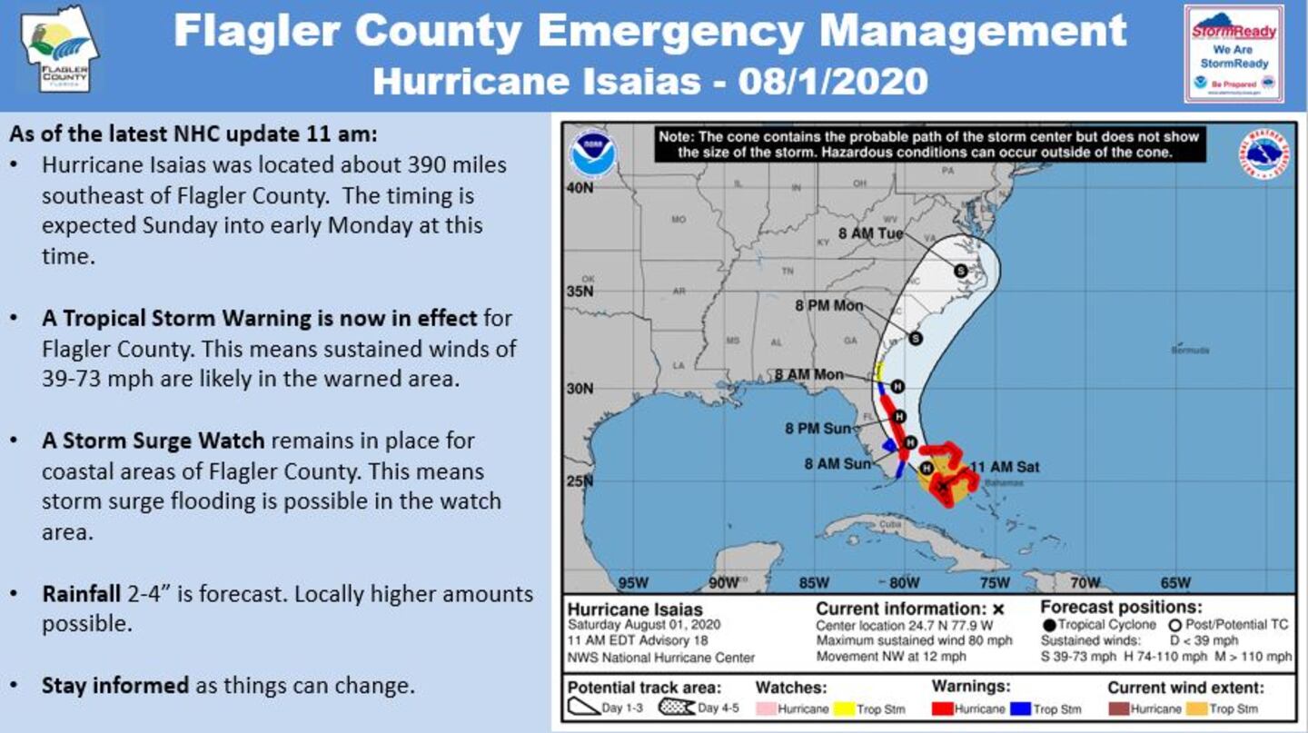
Tropical Storm Warning issued for Flagler County
Flagler County is now under a Tropical Storm Warning. A Storm Surge Watch is also in effect.
>>Storm Surge: What you need to know before the storm hits<<
11:35 a.m. update:
Governor DeSantis calls for Floridians to be prepared, says President granted emergency declaration
Gov. Ron DeSantis urged Floridians to remain alert Saturday morning as Hurricane Isaias continued to churn towards the Atlantic coast.
“This stuff is all very much in flux and even if the eye of the storm stays off the coast, there of course is going to be impacts when you’re talking about hurricane- or tropical storm-force winds,” DeSantis during a brief update at the state Emergency Operations Center.
“So, folks need to be prepared for that. And if you’re in an area, in an evacuation zone, and you do get those orders to evacuate, please heed that call.”
The Governor also Tweeted that President Trump had approved his request for a pre-landfall emergency declaration for the counties in the path of the hurricane.
WATCH LIVE: Press Conference regarding Hurricane #Isaias https://t.co/TdT7xi936a
— Ron DeSantis (@GovRonDeSantis) August 1, 2020
11:00 a.m. update:
Latest track shows Isaias remains on path for Florida coastline
There is no change in the track. Hurricane Isaias currently making landfall on Northern Andros Island, but it has weakened some.
It is still a Category 1 storm with winds at 80 mph.
Right now, it is still expected to parallel the Central Florida coastline through the day tomorrow as a weak Category 1 storm.
>>Click here to watch our 24/7 Weather stream<<

10:30 a.m. update
Sandbags, shopping: Central Florida gets ready
Central Florida residents are spending their Saturday getting ready for the storm.
Reporter Ashley Edlund reports cars are lined up at Chain of Lakes Park in Titusville to collect sandbags.
Brevard County is under a hurricane warning at this hour.
Central Florida Sandbags: Where can I get them? Click here for our running list of locations.
5:00 a.m. update:
Overnight track shows no major changes
No major changes overnight as Hurricane Isaias continues a track towards Central Florida’s coastline.
The National Hurricane Center says Isaias should reach the southeast coast of Florida later today.
It’s closest approach to Central Florida beaches will be through the day on Sunday.
Brevard and Coastal Volusia Counties remain under a hurricane warning.
Interior Volusia, Seminole, Orange and Osceola counties remain under a Tropical Storm Warning.
A hurricane warning means that hurricane conditions are expected somewhere within the warning area. Preparations to protect life and property should be rushed to completion.
A hurricane watch means that hurricane conditions are possible within the watch area. A watch is typically issued 48 hours before the anticipated first occurrence of tropical-storm-force winds, these conditions make outside preparations difficult or dangerous.
Do you know the difference between a tropical storm and a hurricane? Click here to learn about it.
No major changes with the 5am updated track of hurricane Isaias. Still anticipating the storm to closely parallel our coastline on Sunday. pic.twitter.com/tJL8VkOdpR
— Kassandra Crimi (@KCrimiWFTV) August 1, 2020
Hurricane Isaias Timeline: Friday, July 31, 2020

Cox Media Group


