ORLANDO, Fla. — Hurricane Laura made landfall early Thursday morning as a Category 4 storm near Cameron, Louisiana.
3:15 p.m. update
Hurricane Laura is continuing to weaken, now with maximum sustained winds down to 65 mph and moving north at 15 mph. Laura continues to bring strong winds across northern Louisiana and southern Arkansas. The system will continue to lose its punch and is expected to be a tropical depression by Friday morning.
0 of 41
Hurricane Laura A tattered American flag blows in the wind in the aftermath of Hurricane Laura Thursday, Aug. 27, 2020, in Port Arthur, Texas. (AP Photo/Eric Gay) (Eric Gay/AP)
Hurricane Laura Down power lines stretch across a road in the aftermath of Hurricane Laura Thursday, Aug. 27, 2020, in Sabine Pass, Texas. (AP Photo/Eric Gay) (Eric Gay/AP)
Hurricane Laura Down power lines stretch across a road in the aftermath of Hurricane Laura Thursday, Aug. 27, 2020, in Sabine Pass, Texas. (AP Photo/Eric Gay) (Eric Gay/AP)
Hurricane Laura A picture taken on August 27, 2020 shows trees lying across a road as the eye wall of hurricane Laura passes over in Lake Charles, Louisiana. - Hurricane Laura slammed into the southern US state of Louisiana on August 27 and the monster category 4 storm prompted warnings of "unsurvivable" ocean surges and evacuation orders for hundreds of thousands of Gulf Coast residents. The National Hurricane Center (NHC) said "extremely dangerous" Laura would bring winds of 150 miles per hour (240 kilometers per hour) and "destructive waves will cause catastrophic damage" to Louisiana and Texas. (Photo by ANDREW CABALLERO-REYNOLDS / AFP) (Photo by ANDREW CABALLERO-REYNOLDS/AFP via Getty Images) (ANDREW CABALLERO-REYNOLDS/AFP via Getty Images)
Hurricane Laura A picture taken on August 27, 2020 shows a destroyed string of lights swinging in the wind as the eye wall of hurricane Laura passes over in Lake Charles, Louisiana. - Hurricane Laura slammed into the southern US state of Louisiana on August 27 and the monster category 4 storm prompted warnings of "unsurvivable" ocean surges and evacuation orders for hundreds of thousands of Gulf Coast residents. The National Hurricane Center (NHC) said "extremely dangerous" Laura would bring winds of 150 miles per hour (240 kilometers per hour) and "destructive waves will cause catastrophic damage" to Louisiana and Texas. (Photo by ANDREW CABALLERO-REYNOLDS / AFP) (Photo by ANDREW CABALLERO-REYNOLDS/AFP via Getty Images) (ANDREW CABALLERO-REYNOLDS/AFP via Getty Images)
Hurricane Laura A man checks debris blown between two cars as hurricane Laura passes over in Lake Charles, Louisiana on August 27, 2020. - Hurricane Laura slammed into the southern US state of Louisiana on August 27 and the monster category 4 storm prompted warnings of "unsurvivable" ocean surges and evacuation orders for hundreds of thousands of Gulf Coast residents. The National Hurricane Center (NHC) said "extremely dangerous" Laura would bring winds of 150 miles per hour (240 kilometers per hour) and "destructive waves will cause catastrophic damage" to Louisiana and Texas. (Photo by ANDREW CABALLERO-REYNOLDS / AFP) (Photo by ANDREW CABALLERO-REYNOLDS/AFP via Getty Images) (ANDREW CABALLERO-REYNOLDS/AFP via Getty Images)
Hurricane Laura Dustin Amos, right, walks near debris at a gas station on Thursday, Aug. 27, 2020, in Lake Charles, La., after Hurricane Laura moved through the state. (AP Photo/Gerald Herbert) (Gerald Herbert/AP)
Hurricane Laura Dustin Amos walks near debris at a gas station on Thursday, Aug. 27, 2020, in Lake Charles, La., after Hurricane Laura moved through the state. (AP Photo/Gerald Herbert) (Gerald Herbert/AP)
Hurricane Laura Reginald Duhon prepares to work at his home on Thursday, Aug. 27, 2020, in Lake Charles, La., after Hurricane Laura moved through the state. (AP Photo/Gerald Herbert) (Gerald Herbert/AP)
Hurricane Laura Dustin Amos walks near debris at a gas station on Thursday, Aug. 27, 2020, in Lake Charles, La., after Hurricane Laura moved through the state. (AP Photo/Gerald Herbert) (Gerald Herbert/AP)
Hurricane Laura LAKE CHARLES, LOUISIANA - AUGUST 27: Reagan Cotten and Kate Cotten walk through the downtown area after Hurricane Laura passed through on August 27, 2020 in Lake Charles, Louisiana . The hurricane hit with powerful winds causing extensive damage to the city. (Photo by Joe Raedle/Getty Images) (Joe Raedle/Getty Images)
Hurricane Laura SABINE PASS, TX - AUGUST 27: Flooding caused by Hurricane Laura on August 27, 2020 in Sabine Pass, Texas. Hurricane Laura came ashore bringing rain and high winds to the eastern part of the state. (Photo by Eric Thayer/Getty Images) (ERIC THAYER/Getty Images)
Hurricane Laura SABINE PASS, TX - AUGUST 27: Flooding caused by Hurricane Laura on August 27, 2020 in Sabine Pass, Texas. Hurricane Laura came ashore bringing rain and high winds to the eastern part of the state. (Photo by Eric Thayer/Getty Images) (Eric Thayer/Getty Images)
Hurricane Laura LAKE CHARLES, LOUISIANA - AUGUST 27: A street is seen strewn with debris and downed power lines after Hurricane Laura passed through the area on August 27, 2020 in Lake Charles, Louisiana . The hurricane hit with powerful winds causing extensive damage to the city. (Photo by Joe Raedle/Getty Images) (Joe Raedle/Getty Images)
Hurricane Laura LAKE CHARLES, LOUISIANA - AUGUST 27:A Lake Charles police officer helps clear the streets in the downtown area after Hurricane Laura passed through on August 27, 2020 in Lake Charles, Louisiana . The hurricane hit with powerful winds causing extensive damage to the city. (Photo by Joe Raedle/Getty Images) (Joe Raedle/Getty Images)
Hurricane Laura LAKE CHARLES, LOUISIANA - AUGUST 27: Kyana Myers looks into a room that had its roof blown off as Hurricane Laura passed through the area on August 27, 2020 in Lake Charles, Louisiana . The hurricane hit with powerful winds causing extensive damage to the city. (Photo by Joe Raedle/Getty Images) (Joe Raedle/Getty Images)
Hurricane Laura LAKE CHARLES, LOUISIANA - AUGUST 27: People stand next to a hotel that had parts of its roof blown off as Hurricane Laura passed through the area on August 27, 2020 in Lake Charles, Louisiana . The hurricane hit with powerful winds causing extensive damage to the city. (Photo by Joe Raedle/Getty Images) (Joe Raedle/Getty Images)
Hurricane Laura LAKE CHARLES, LOUISIANA - AUGUST 27: A person stands next to a hotel that had parts of its roof blown off as Hurricane Laura passed through the area on August 27, 2020 in Lake Charles, Louisiana . The hurricane hit with powerful winds causing extensive damage to the city. (Photo by Joe Raedle/Getty Images) (Joe Raedle/Getty Images)
Hurricane Laura LAKE CHARLES, LOUISIANA - AUGUST 27: Mitch PIckering plays his guitar while walking through the downtown area after Hurricane Laura passed through on August 27, 2020 in Lake Charles, Louisiana . The hurricane hit with powerful winds causing extensive damage to the city. (Photo by Joe Raedle/Getty Images) (Joe Raedle/Getty Images)
Hurricane Laura LAKE CHARLES, LOUISIANA - AUGUST 27: A room that had its roof blown off is seen in a hotel after Hurricane Laura passed through the area on August 27, 2020 in Lake Charles, Louisiana . The hurricane hit with powerful winds causing extensive damage to the city. (Photo by Joe Raedle/Getty Images) (Joe Raedle/Getty Images)
Hurricane Laura LAKE CHARLES, LOUISIANA - AUGUST 27: Donnie Rogers prepares to raise the American flag on a pole after Hurricane Laura passed through the area on August 27, 2020 in Lake Charles, Louisiana . The hurricane hit with powerful winds causing extensive damage to the city. (Photo by Joe Raedle/Getty Images) (Joe Raedle/Getty Images)
Hurricane Laura PORT ARTHUR, TX - AUGUST 27: Oil refineries are seen after Hurricane Laura made landfall on August 27, 2020 in Port Arthur, Texas. Hurricane Laura came ashore bringing rain and high winds to the eastern part of the state. (Photo by Eric Thayer/Getty Images) (ERIC THAYER/Getty Images)
Hurricane Laura LAKE CHARLES, LOUISIANA - AUGUST 27: A building with its windows blown out is seen in the downtown area after Hurricane Laura passed through on August 27, 2020 in Lake Charles, Louisiana . The hurricane hit with powerful winds causing extensive damage to the city. (Photo by Joe Raedle/Getty Images) (Joe Raedle/Getty Images)
Hurricane Laura LAKE CHARLES, LOUISIANA - AUGUST 27: Lake Charles police officers help clear the roads in the downtown area after Hurricane Laura passed through on August 27, 2020 in Lake Charles, Louisiana . The hurricane hit with powerful winds causing extensive damage to the city. (Photo by Joe Raedle/Getty Images) (Joe Raedle/Getty Images)
Hurricane Laura PORT ARTHUR, TX - AUGUST 27: Oil refineries are seen after Hurricane Laura made landfall on August 27, 2020 in Port Arthur, Texas. Hurricane Laura came ashore bringing rain and high winds to the eastern part of the state. (Photo by Eric Thayer/Getty Images) (ERIC THAYER/Getty Images)
Hurricane Laura LAKE CHARLES, LOUISIANA - AUGUST 27: A Lake Charles police officer helps clear the streets in the downtown area after Hurricane Laura passed through on August 27, 2020 in Lake Charles, Louisiana . The hurricane hit with powerful winds causing extensive damage to the city. (Photo by Joe Raedle/Getty Images) (Joe Raedle/Getty Images)
Hurricane Laura LAKE CHARLES, LOUISIANA - AUGUST 27: A person is seen walking through a building with its windows blown out in the downtown area after Hurricane Laura passed through on August 27, 2020 in Lake Charles, Louisiana . The hurricane hit with powerful winds causing extensive damage to the city. (Photo by Joe Raedle/Getty Images) (Joe Raedle/Getty Images)
Hurricane Laura SABINE PASS, TX - AUGUST 27: Flooding caused by Hurricane Laura on August 27, 2020 in Sabine Pass, Texas. Hurricane Laura came ashore bringing rain and high winds to the eastern part of the state. (Photo by Eric Thayer/Getty Images) (ERIC THAYER/Getty Images)
Hurricane Laura LAKE CHARLES, LOUISIANA - AUGUST 27: A building with its windows blown out is seen in the downtown area after Hurricane Laura passed through on August 27, 2020 in Lake Charles, Louisiana . The hurricane hit with powerful winds causing extensive damage to the city. (Photo by Joe Raedle/Getty Images) (Joe Raedle/Getty Images)
Hurricane Laura LAKE CHARLES, LOUISIANA - AUGUST 27: A Lake Charles police officer helps clear the streets in the downtown area after Hurricane Laura passed through on August 27, 2020 in Lake Charles, Louisiana . The hurricane hit with powerful winds causing extensive damage to the city. (Photo by Joe Raedle/Getty Images) (Joe Raedle/Getty Images)
Hurricane Laura LAKE CHARLES, LOUISIANA - AUGUST 27: An escalator is seen in a building that had its windows blown in the downtown area after Hurricane Laura passed through on August 27, 2020 in Lake Charles, Louisiana . The hurricane hit with powerful winds causing extensive damage to the city. (Photo by Joe Raedle/Getty Images) (Joe Raedle/Getty Images)
Tropical Weather Texas Crew members of a shrimp boat called the Sea Lion V prepare as they wait for Hurricane Laura to make landfall, Wednesday, Aug. 26, 2020, in Port Arthur, Texas. (AP Photo/Eric Gay) (Eric Gay)
Tropical Weather Texas Port Arthur firefighters lower a U.S. flag at a post office at sunset as they wait for Hurricane Laura to make landfall, Wednesday, Aug. 26, 2020, in Port Arthur, Texas. (AP Photo/Eric Gay) (Eric Gay)
Tropical Weather Water falls over Jimmy Villarreal, of Galveston, Texas as a wave hits the seawall while he was watching the surf stirred up by Hurricane Laura Wednesday, Aug. 26, 2020 in Galveston, Texas. (Brett Coomer/Houston Chronicle via AP) (Brett Coomer)
Tropical Weather Texas Port Arthur firefighters stare at a sea wall at sunset as they wait for Hurricane Laura to make landfall, Wednesday, Aug. 26, 2020, in Port Arthur, Texas. (AP Photo/Eric Gay) (Eric Gay)
11 a.m. update
Laura has been downgraded to a Category 1 storm. It continues to weaken rapidly and is forecast to become a tropical storm within the next few hours.
The storm’s maximum sustained winds are 75 mph.
Louisiana Gov. John Bel Edwards said the state’s first reported fatality from Hurricane Laura is a 14-year-old girl who died when a tree fell on her home in Leesville, Louisiana.
Through Friday, Laura is expected to produce additional rainfall totals of 4 to 8 inches across portions of Louisiana, Mississippi and Arkansas, with isolated storm totals of 18 inches over Louisiana.
This rainfall will continue to cause widespread flash and urban flooding, small streams and creeks to overflow their banks, and minor to moderate freshwater river flooding.
The National Hurricane Center said high water levels persist along portions of the Gulf Coast.
8 a.m. update
Hurricane Laura continues to weaken rapidly as damaging winds and flooding rainfall spread inland over western and central Louisiana.
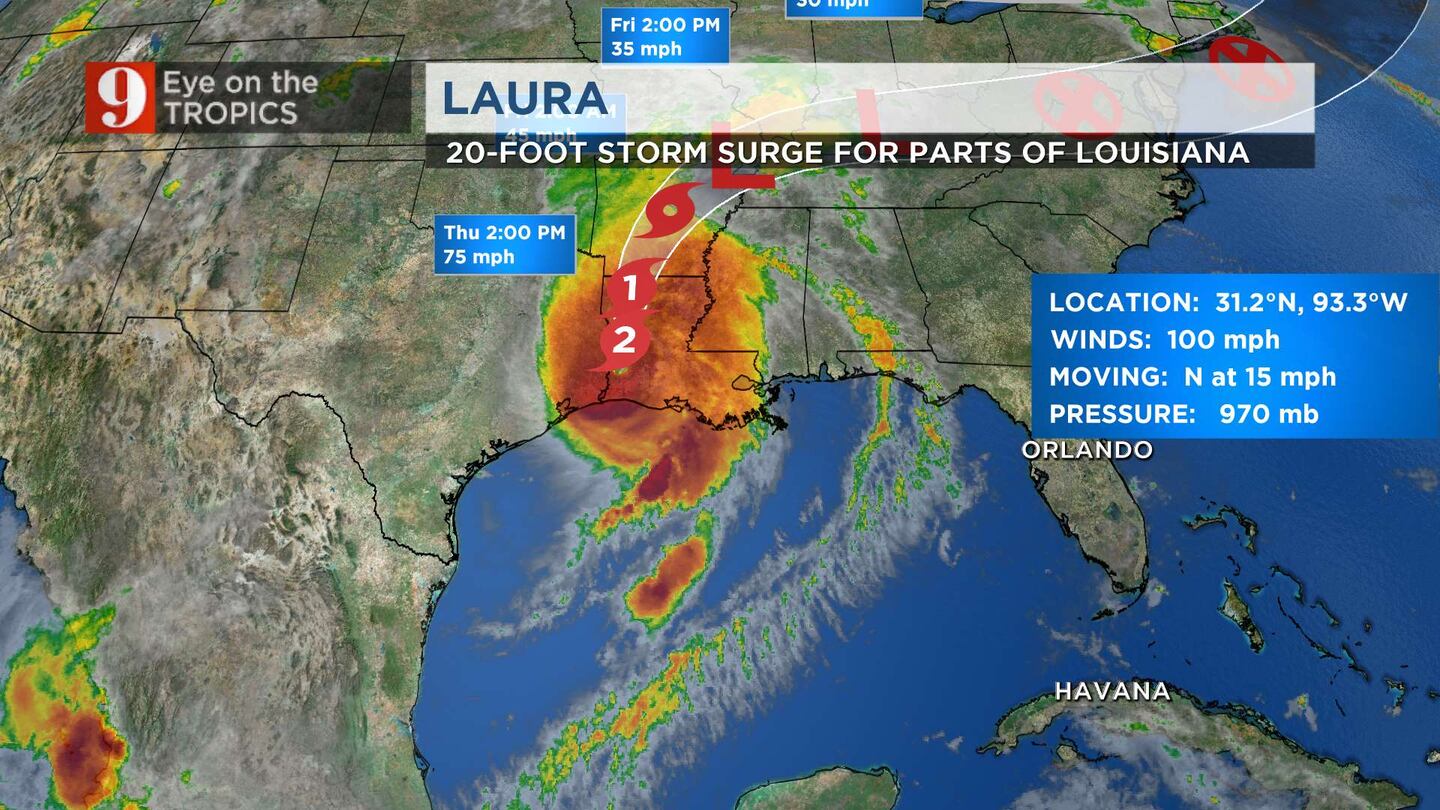
The National Hurricane Center said life-threatening storm surge continues along much of the Louisiana coastline.
Weather officials said maximum sustained winds are at 100 mph. Forecasters expect Laura to continue weakening throughout the day. It is expected to become a tropical storm later Thursday.
Laura 8am
6:30 a.m. update
Hurricane Laura was downgraded to a Category 2 storm, with 110 mph maximum sustained winds.
The National Hurricane Center said hurricane conditions are spreading farther inland across southwestern Louisiana.
Weather officials said “catastrophic” storm surge, hurricane force winds and flash flooding will continue Thursday morning.
5 a.m. update
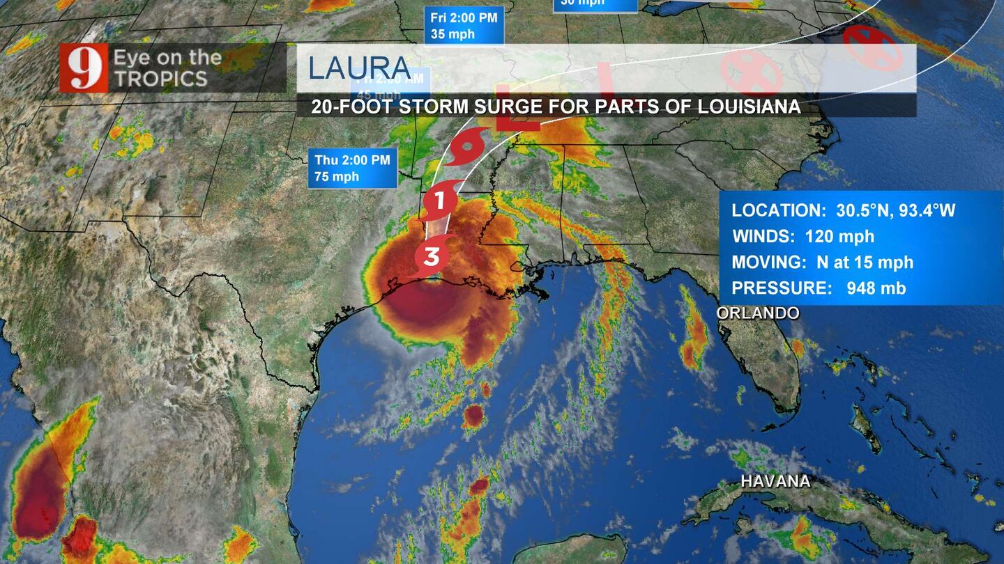
Hurricane Laura was downgraded to a Category 3 storm, with 120 mph maximum sustained winds. Forecasters expect Laura to rapidly weaken and become a tropical storm later Thursday.
The National Hurricane Center said “catastrophic storm surge, extreme winds and flash flooding continue in portions of Louisiana.”
Laura is moving toward the north at 15 mph. The National Hurricane Center said it should continue moving north throughout the day. A northeastward to east northeastward motion is expected Thursday night and Friday.
Laura will move across southwestern Louisiana Thursday morning and continue northward across the state throughout the afternoon.
The center of Laura is forecast to move over Arkansas tonight, the mid-Mississippi Valley on Friday and the mid-Atlantic states on Saturday.
Hurricane Laura struck land around 2 a.m. Thursday near Cameron, Louisiana packing 150 mph winds, Channel 9 meteorologist Brian Shields said. Laura continues to produce dangerous and destructive winds throughout much of Louisiana.