ORLANDO, Fla. — A major fall front is making its way through Central Florida on Thursday.
Read live weather updates below:
>>> STREAM CHANNEL 9 EYEWITNESS NEWS LIVE <<<
>>> CLICK HERE FOR LIVE RADAR <<<
Click here to download the WFTV weather app for live updates to your phone, and click here to stream weather coverage on the WFTV now app.
5:55 p.m. update
The tornado warnings in Brevard and Osceola counties have both expired.
5:25 p.m. update
A tornado warning has been issued for a portion of Brevard County through 5:45 p.m.
Tornado Warning has been extended into Brevard County pic.twitter.com/Q9ETjVlzzd
— Kassandra Crimi (@KCrimiWFTV) October 28, 2021
5:10 p.m.
A tornado warning has been issued for a portion of southern Osceola County through 5:30 p.m.
Tornado Warning for far Southern Osceola County. @TTerryWFTV is tracking on @WFTV now. pic.twitter.com/ASFH6wn1jZ
— Kassandra Crimi (@KCrimiWFTV) October 28, 2021
Tornado Warning Take action now if you are in shaded area.
— Kassandra Crimi (@KCrimiWFTV) October 28, 2021
A tornado has been detected. Go to the lowest, most central room in your home. Stay away from windows. Indian River, Osceola #StormAlert9 pic.twitter.com/XrxRYP4SDQ
4:35 p.m.
A couple strong storms will hang around through the evening. some of the stronger storms this evening. Lingering rain and a big cool down will follow.
Closing out some of the stronger storms this evening.
— Kassandra Crimi (@KCrimiWFTV) October 28, 2021
Lingering rain and a big cool down will follow. pic.twitter.com/Mx3l8vJoDy
4:15 p.m. update
Channel 9 viewer Phil Hancock sent in the video below of very gusty conditions with some broad circulation from New Smyrna Beach.
Very gusty with some broad circulation from new Smyrna Beach. We were live on TV warning for this area. Thanks to Phil Hancock. @WFTV pic.twitter.com/M3Lu9Y1uVN
— Tom Terry (@TTerryWFTV) October 28, 2021
3:50 p.m. update
The tornado warning for portions of Volusia County has expired. Strong storms are continuing to move toward the east coast of Central Florida.
READ: Watch vs. Warning: 10 things to know to stay safe during a tornado
3:35 p.m. update
A tornado warning has been issued for a portion of Volusia County, including New Smyrna Beach, Edgewater, and Glencoe, until 3:45 p.m.
Chief meteorologist Tom Terry is tracking the storm LIVE now on Ch. 9. Click here to tune in.
Tornado Warning including New Smyrna Beach FL, Edgewater FL, Glencoe FL until 3:45 PM EDT pic.twitter.com/tJ0G8GU7En
— NWS Melbourne (@NWSMelbourne) October 28, 2021
3:20 p.m. update
Heavy rain and gusty winds are moving into metro Orlando right now. At this time, they are below severe limits.
Heavy rain, gusty winds, in metro Orlando right now. At this time, they are below severe limits. pic.twitter.com/nUQs7zFcNY
— Rusty McCranie (@RMcCranieWFTV) October 28, 2021
2:45 pm. update
Osceola County has been added to the tornado watch encompassing most of Central Florida through 5 p.m.
A strong line of storms has also triggered severe thunderstorm warnings just north and west of downtown Orlando. Some cities in the warnings include Clermont, Winter Garden, Ocoee, Apopka, Altamonte Springs.
A couple severe thunderstorm warnings continue just north and west of downtown Orlando. Some cities in the warnings include Clermont, Winter Garden, Ocoee, Apopka, Altamonte Springs. pic.twitter.com/vN9lpYMUpx
— Rusty McCranie (@RMcCranieWFTV) October 28, 2021
1:55 p.m. update
Channel 9 chief meteorologist Tom Terry said a rough line of storms is moving rapidly toward the I-4 corridor. He advises that you plan on seeking shelter from gusty winds of 50-60 mph.
Rough storms are moving rapidly toward the I-4 corridor. Plan on seeking shelter for gusty winds of 50-60mph. #StormAlert9 pic.twitter.com/2e5PYefCyR
— Tom Terry (@TTerryWFTV) October 28, 2021
READ: Central Florida school districts issue weather alert for possible dismissal delays
12:50 p.m. update
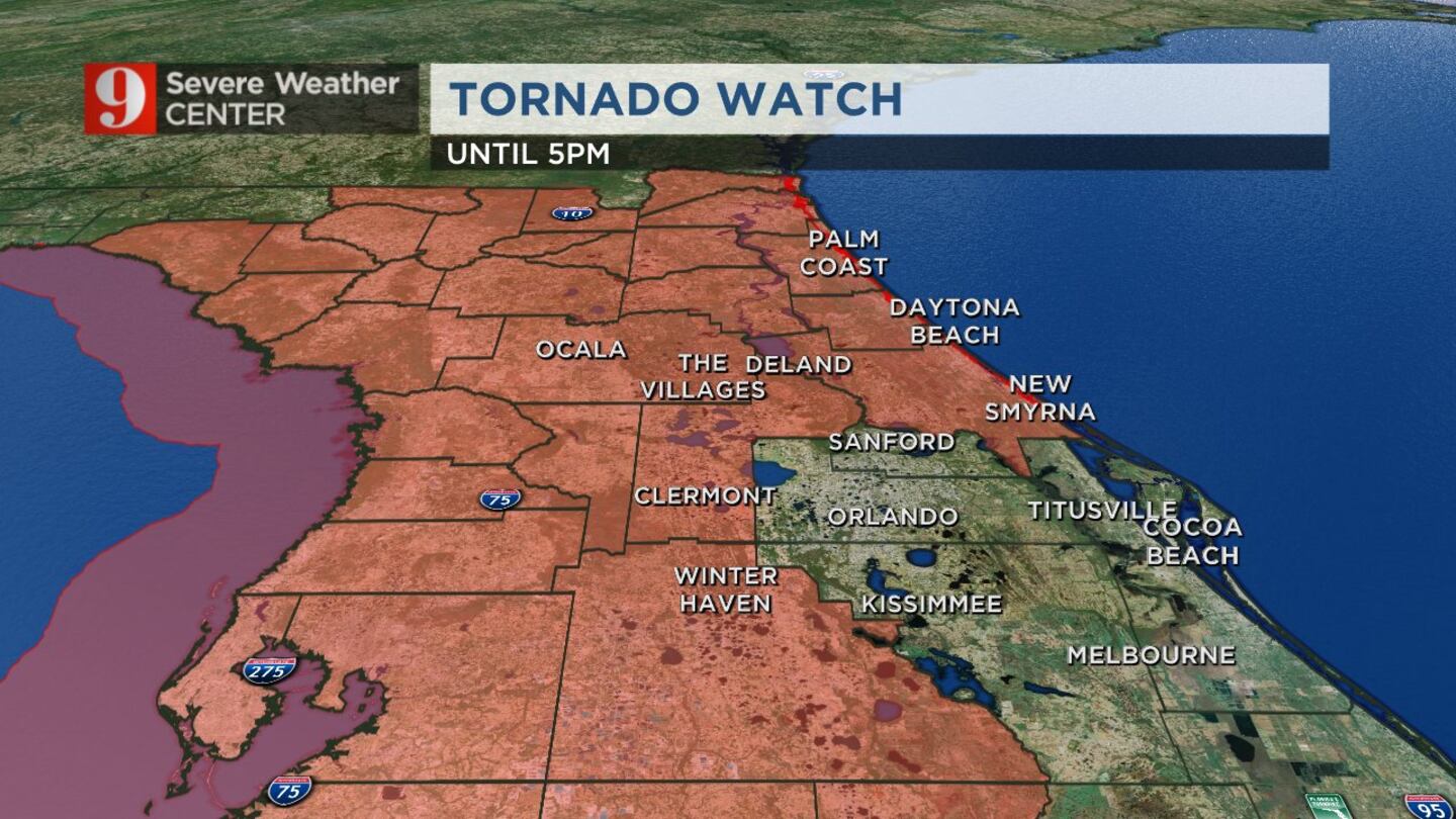
A tornado watch has been extended into Orange and Seminole counties until 5 p.m.
Orange (metro Orlando) and Seminole counties now included in the tornado watch until 5pm. pic.twitter.com/sVZuFv0vf5
— Rusty McCranie (@RMcCranieWFTV) October 28, 2021
12:10 p.m. update
A severe thunderstorm warning was issued in Putnam, Alachua and Marion counties.
Meteorologist Kassandra Crimi said 60 mph gusts and hail are possible.
Severe Thunderstorm Warning Putnam, Alachua, Marion
— Kassandra Crimi (@KCrimiWFTV) October 28, 2021
Stay indoors! 60mph gusts & hail possible. Stay away from windows. #StormAlert9 pic.twitter.com/jy3lvHoRZ1
10:35 a.m. update
Meteorologist Rusty McCranie said the first storms of the day are heading to the southwest area of the metro.
The storms are covering up Interstate 4 in Polk County. They are moving toward northwest Osceola County and will eventually enter Orange County.
McCranie said the storms will impact the attractions area soon.
First storms of the day heading into the SW sides of the metro. Storms covering up I-4 in Polk county moving NE into NW Osceola and eventually SW Orange counties. These storms will impact the attractions area in the next 30 minutes. pic.twitter.com/0UX0EKRkXZ
— Rusty McCranie (@RMcCranieWFTV) October 28, 2021
9:20 a.m. update
A tornado watch has been issued for some Central Florida counties until 5 p.m.
Lake, Sumter, Volusia, Flagler, Marion and Polk counties are under the tornado watch.
Tornado Watch now in effect for most of Central Florida until 5pm. At this point, it does not include metro Orlando. However, that could change, and all of Central Florida needs to stay weather aware throughout the day. pic.twitter.com/fMqfUUyPgW
— Rusty McCranie (@RMcCranieWFTV) October 28, 2021
Meteorologist Rusty McCranie said the tornado watch does not include metro Orlando but that could change.
All of Central Florida needs to stay weather aware throughout the day.
8:05 a.m. update
The rain has stopped for now in Marion County.
A line of storms is making its way though the Tampa area now. The storms will arrive in Central Florida later today.
Meteorologist Brian Shields said Central Floridians should stay weather aware as the storms move into the area.
First the storms, then the cool air. Please stay aware of the weather today. We will get the payoff this weekend! pic.twitter.com/ElJ4z9UCTN
— Brian Shields, WFTV (@BrianWFTV) October 28, 2021
6:25 a.m. update
Some storms are starting to move into Marion County.
Rain is moving toward the Ocala area. Most of the front remains in northwestern Florida.
WATCH: Tornado crosses Texas freeway in dramatic viral video
It will start moving inland throughout the morning and into the afternoon hours.
Major fall front moving in. Severe risk, then much cooler! Tracking now on @WFTV! pic.twitter.com/DbzG0x9WpH
— Brian Shields, WFTV (@BrianWFTV) October 28, 2021
5 a.m. update
Strong storms will start to move in by late morning.
The severe threat for rain and storms is highest this afternoon.
READ: Daylight saving time 2021: When do we set our clocks back?
Meteorologist Brian Shields is tracking the storms county-by-county now on Channel 9 Eyewitness News This Morning. Click here to watch live weather updates.
Strong storms by late morning, but the severe threat is highest this afternoon. Busy! Tracking county-by-county on Channel 9 right now. pic.twitter.com/C7BjMf91UM
— Brian Shields, WFTV (@BrianWFTV) October 28, 2021
4:30 a.m. update
Rain and storms will begin to race in Thursday from the west to the east.
Residents in Sumter, Lake and Marion can expect to see the storms during the mid-morning hours.
READ: Costco raises employees’ minimum hourly wage to $17
At midday, the storms will be near Interstate 4 in Orange, Seminole, Volusia, Osceola and Flagler counties.
During the mid-afternoon hours, the storms will continue to be near the I-4 area and south, in Orange, Osceola and Brevard counties.
READ: TikTok star, comedian Huey Haha dead at 22
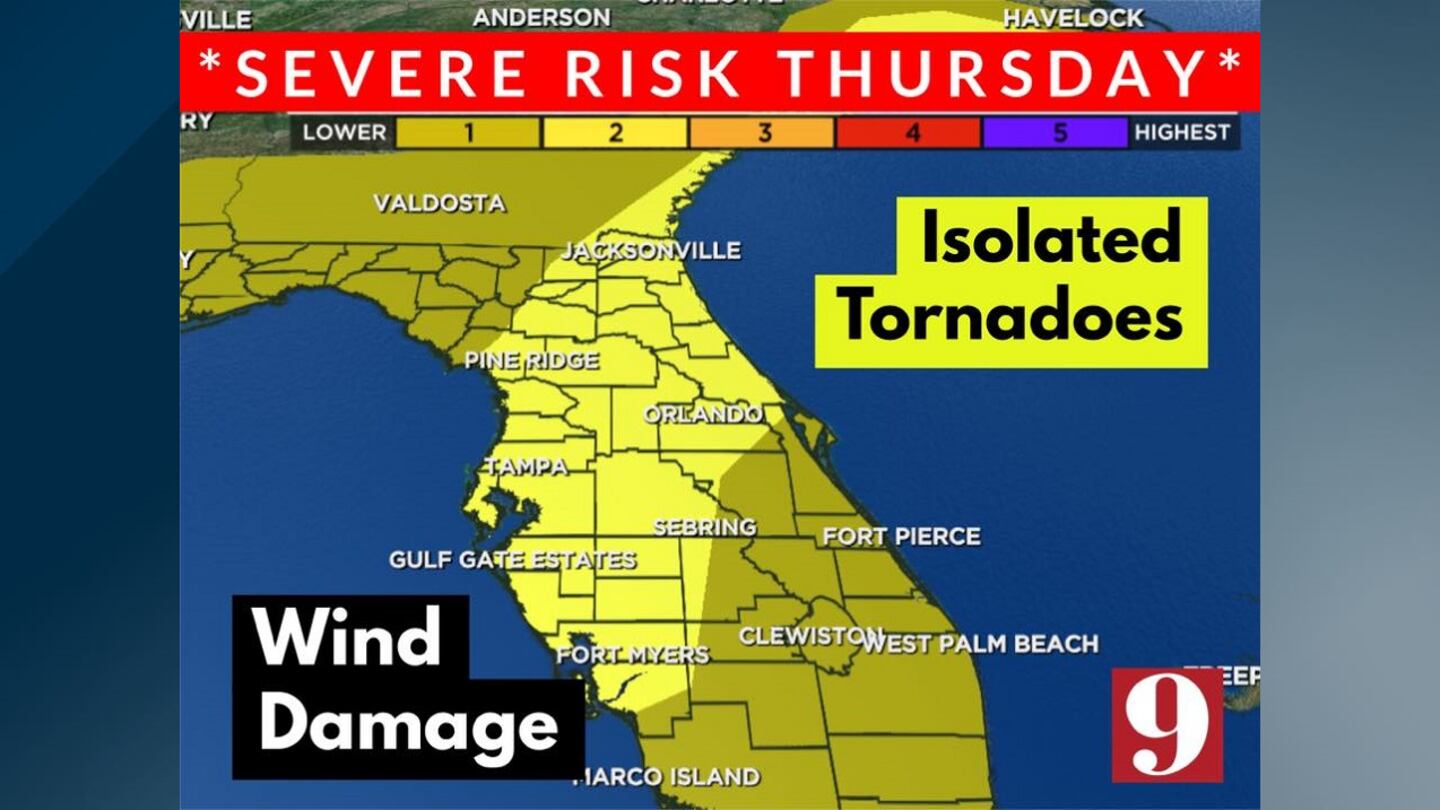
Meteorologist Brian Shields said some storms could be strong, with a few severe storms. In any severe storms, damaging winds are possible. Isolated tornadoes are also a risk.
Visit our hurricane section: EYE ON THE TROPICS
Follow our Severe Weather team on Twitter for live updates:
Click here to download the WFTV weather app for live updates to your phone, and click here to stream weather coverage on the WFTV now app.
©2021 Cox Media Group


