
ORLANDO, Fla. — >> CLICK HERE FOR LIVE DOPPLER 9 RADAR <<
>> WATCH OUR NEWSCAST LIVE HERE <<
Severe thunderstorms are moving through Central Florida.
A severe thunderstorm warning was issued for Marion County until 6 p.m.
Chief meteorologist Tom Terry is tracking the storms on Channel 9.
Tracking more slow movers today! pic.twitter.com/8hw7Oc4YDX
— Tom Terry (@TTerryWFTV) June 11, 2020
Watch Doppler 9 radar below:
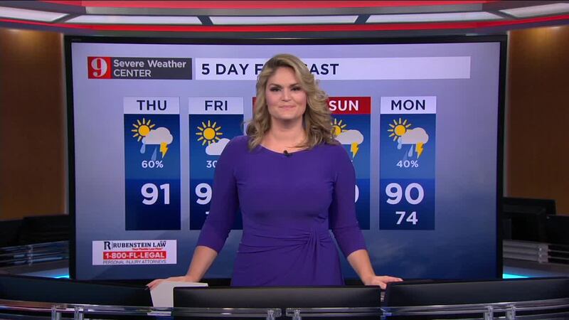
Another day of hot and steamy conditions is expected for Central Florida.
Here’s what you can expect:
- Temps in the lower 90s.
- A 60 percent chance of afternoon storms.
- Storms will gradually cease after sunset.
Make sure to always have at least 3 ways of receiving weather alerts. You can download our Free WFTV Weather App (make sure to allow notifications) to receive alerts wherever you are located.
VIEWER PHOTOS: Tornado sightings and damage across Central Florida
Read more: Tornadic weekend for Central Florida: 3 tornadoes, one left a local family without a home
SEE pictures: Hole-punch clouds seen in Central Florida on November 2019
Watch your full 5 Day Forecast below:
DOWNLOAD OUR FREE WFTV WEATHER APP TO RECEIVE ALERTS
Read: Forecasters highly confident about an active 2020 Hurricane Season
Entérese del pronóstico del tiempo, en español, por nuestra meteoróloga Irene Sans:
Follow our Severe Weather team on Twitter for live updates:
- Chief meteorologist Tom Terry
- Brian Shields
- Irene Sans
- Kassandra Crimi
- George Waldenberger
- Rusty McCranie
© 2020 Cox Media Group


