ORLANDO, Fla. — Thunderstorms were bringing lightning and heavy downpours to the Orlando area Monday afternoon.
The storms will move east across Central Florida over the next several hours.
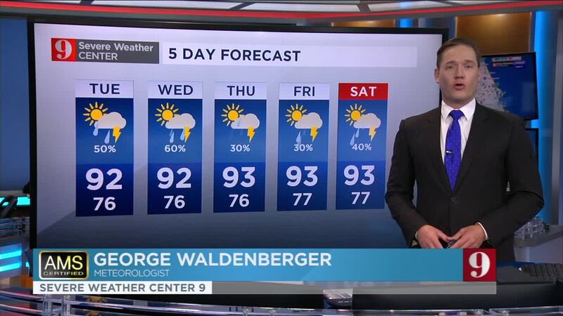
“By the end of the afternoon, a lot of the storm activity will move into coastal areas before moving offshore and tapering for the evening,” meteorologist George Waldenberger said. “(The) main threats will be lightning and localized downpours, with some isolated minor street flooding possible.”
>>> CLICK HERE FOR LIVE DOPPLER 9 RADAR <<<
Temperatures are forecast to drop to the mid 70s Monday evening.
The afternoon storms will continue Tuesday.
Elsewhere, a tropical disturbance in the central Atlantic should further develop.
Read: Tropical disturbance moving across the Atlantic, expected to develop early this week
#Orlando, all wet. pic.twitter.com/CxGEIJWfwD
— George Waldenberger (@GWaldenWFTV) July 27, 2020
“Within the next couple days, the next tropical depression or storm is likely to form out of this,” Waldenberger said. “It’s something we’ll keep an eye on through the end of the week to see how organized it can become and where it will head.”
Click here to read more about that system.
Visit our hurricane section: EYE ON THE TROPICS
Visite la sección en español: Temporada de huracanes
Send us your pictures! PHOTOS: Comet Neowise seen by Central Florida residents
Read: Tropical Storm Gonzalo entering the Caribbean this weekend
Storm clouds brewing once again for the p.m. drive. Drive safely, #Orlando. pic.twitter.com/WoE1MCUHXW
— George Waldenberger (@GWaldenWFTV) July 27, 2020
Rain is developing to cool things off...watch out for lightning. #Orlando pic.twitter.com/og7A6pnlzO
— George Waldenberger (@GWaldenWFTV) July 27, 2020
Storms rolling in over downtown #Orlando. #WFTV pic.twitter.com/gL6bGn9Ib9
— George Waldenberger (@GWaldenWFTV) July 27, 2020
Entérese de todo lo que ocurre en el trópico en nuestra pagina en español.
Follow our Severe Weather team on Twitter for live updates:
- Chief meteorologist Tom Terry
- Brian Shields
- Irene Sans
- Kassandra Crimi
- George Waldenberger
- Rusty McCranie
© 2020 Cox Media Group


