
ORLANDO, Fla. — >> CLICK HERE FOR LIVE DOPPLER 9 RADAR <<
Temperatures stayed hot throughout Central Florida with strong storms moving fast.
We had a similar setup to the one Central Florida experienced on Wednesday. Storms moved over the Metro areas by 2 p.m. and eastward. Some storms were strong and produced torrential rains. By 4 p.m., the storms were along the coast.
Temperatures by midnight will barely be stepping down from the 80s. By sunrise on Friday, temperatures will be around 77 degrees, with the winds from the southwest.
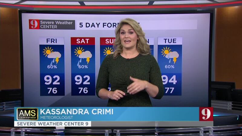
Expect a higher chance for showers and storms on Friday afternoon. Highs will be between 93 and 96 degrees but heat indices will range between 100 and 103 degrees. This (extra) warmth is mainly caused by the southwesterly winds over Central Florida. The increase in storm coverage is due to the proximity of a stationary front that will aid the entrance of instability to our area.
Coming 4th of July weekend: Buck Moon Eclipse!
4th OF JULY HOLIDAY WEEKEND FORECAST
The winds will stay out of the south-southwest throughout the weekend, but there will be more clouds and a much higher chance for rain and storms as the frontal boundary stays put just over North Florida. For Saturday and Sunday, about 80 percent of Central Florida should receive measurable rain. Storm will be moving from west to east, and some could be strong at times.
Highs through the weekend will stay between the upper-80s and low-90s. Lows between the low to mid-70s.
Make sure to always have at least three ways of receiving weather alerts. You can download our Free WFTV Weather App (make sure to allow notifications) to receive alerts wherever you are located.
OH, CENTRAL FLORIDA! Rainbow, lightning bolt recorded over Ormond Beach neighborhood
>> WATCH OUR NEWSCAST LIVE HERE <<
Read: Saharan dust in Central Florida: What is it? What does it do?
DOWNLOAD OUR FREE WFTV WEATHER APP TO RECEIVE ALERTS
Read: Forecasters highly confident about an active 2020 Hurricane Season
Watch your 5-day forecast below:
Entérese de todo lo que ocurre en el trópico en nuestra pagina en español.
Follow our Severe Weather team on Twitter for live updates:
- Chief meteorologist Tom Terry
- Brian Shields
- Irene Sans
- Kassandra Crimi
- George Waldenberger
- Rusty McCranie
© 2020 Cox Media Group


