
ORLANDO, Fla. — Channel 9 Eyewitness News meteorologists are tracking the storm live online and on-air. Read live updates below:
>>> Click here to tune into Channel 9 Eyewitness News for live forecast updates and analysis <<<
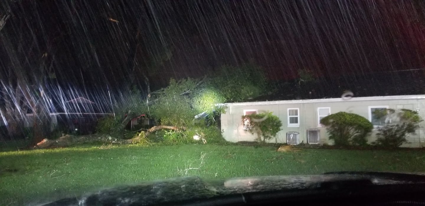
11:05 p.m. update: The City of DeLand posted an image on their Facebook page of a tree down near an Assistant Living Facility home in the 400 block of North McDonald Drive. There were no injuries reported.
11:00 p.m. update: Dorian maintains speed and maximum sustained winds as it moves about 100 miles east of the Central Florida coast. Dorian's rain bands have affected inland portions of Central Florida, triggering some flood advisories, one near the I-4 corridor where rainfall amount reached 1-2 inches.
Wind gusts have ranged between 54 mph and 76 mph in Cape Canaveral. In Volusia County, a sustained wind measured 40mph and gust 52 mph in Edgewater.
11pm martes: Dorian mantiene la velocidad y los vientos máximos sostenidos mientras se mueve a unos 160 kilómetros al este de la costa central de Florida. Las bandas de lluvia de Dorian han afectado partes del interior de la Florida Central, provocando algunos avisos de inundación, uno cerca del corredor I-4 donde la cantidad de lluvia alcanzó 1-2 pulgadas.
Los vientos han estado mas pronunciados sobre la costa, como se pronosticaba. En Cabo Canaveral ráfagas de vientos entre 40 mph y 76 mph han sido regitradas. En Edgewater, en el condado Volusia se registro viento sostenido de 40 mph y con ráfaga de 52 mph.
10:16 p.m. update: The Granada Bridge in Ormond Beach has closed due to wind conditions from Hurricane Dorian. It will reopen once conditions improve.
8:56 p.m. update: Ormond Beach has updated their curfew to residents. The latest curfew is in effect Tuesday at 6 p.m. to Wednesday at 6 a.m. and also Wednesday at 6 p.m. to Thursday at 6 a.m.
8:07 p.m. update: Dorian remains a Category 2 hurricane, moving northwest at 6 mph. During the evening through the overnight hours expect heavy rain bands to be moving across Central Florida. Some rain bands could produce strong gusts, especially along the coast. But even inland, some rain bands could produce win gusts of about 35 mph.
8:00 p.m. update: Brevard County Emergency Management has reported 690 outages for 315,400 electric customers.
7:02 p.m. update: The University of Central Florida will remain closed through Thursday, September 5 and reopen Friday, September 6.
6:30 p.m. WFTV programming update: Due to our continuing coverage of Hurricane Dorian, "Jeopardy!" will air from 1 a.m. to 1:30 a.m. and Wheel of Fortune will air from 1:30 a.m. to 2 a.m. on Wednesday morning. Please set your DVRs accordingly.
6:15 p.m. update: Osceola County Schools are now slated to reopen Thursday, September 5. Schools will remain closed for Hurricane Dorian on Wednesday, September 4.
6:10 p.m. update: A Tornado Warning has been issued for the city of Micco in Brevard County until 6:30 p.m. Micco is located 12 miles east of Satellite Beach.
6: 00 p.m. update: Florida Power & Light Company has reported the restoration of nearly 70,000 outages affecting Florida's east coast. Most of the outages have been the result of trees and vegetation falling on equipment and power lines, according to the company.
5:24 p.m. update: Universal announced that Universal Studios Florida and Universal's Island of Adventure will be closing as of 6 p.m. Tuesday. CityWalk venues will continue to operate throughout the evening, but will close earlier than normal in accordance with the weather.
5: 00 p.m. update: Dorian holds maximum sustained winds at 110 mph, moving northwest at about 6 mph. It is still a Category 2 hurricane, but it is expected to continue weakening as it moves northward. The track continues to shift even farther east, which is great news for Central Florida. Wind shear is denting Dorian, especially across its western side. The wind field also continues to increase and is not symmetric. A larger bulge is noticeable to the right side of the storm.
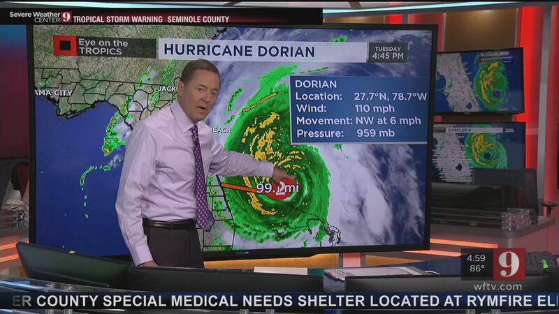
Hurricane-force winds extend outward up to 60 miles from the center and tropical-storm-force winds extend outward up to 175 miles. Dorian’s eye has expanded and has become better organized. This organization and expansion was forecast and expected as the system is fighting to survive but will gradually weaken as it moves toward larger latitudes and wind shear dents it.
Life-threatening storm surge and dangerous winds are expected along portions of the Florida east coast and the coasts of Georgia, South Carolina, and North Carolina, regardless of the exact track of Dorian's center. Water levels could rise well in advance of the arrival of strong winds. Residents in these areas should follow advice given by local emergency officials.
Actualización 5pm martes: Dorian mantiene vientos máximos sostenidos a 110 mph, moviéndose hacia el noroeste a aproximadamente 6 mph. Todavía es un huracán de categoría 2, pero se espera que continúe debilitándose a medida que avanza hacia el norte. La trayectoria continúa cambiando aún más hacia el este, lo cual es una gran noticia para Florida Central. La cizalladura del viento está afectando a Dorian, especialmente en su lado occidental.
El campo de viento también continúa aumentando, pero no es simétrico. Se nota un bulto más grande en el lado derecho de la tormenta. Los vientos con fuerza de huracán se extienden hacia afuera hasta 60 millas del centro y los vientos con fuerza de tormenta tropical se extienden hacia afuera hasta 175 millas.
El ojo de Dorian se ha expandido y se ha organizado mejor. Esta organización y expansión estaba pronosticada y se esperaban a medida que el sistema lucha por sobrevivir, pero se debilitará gradualmente a medida que avanza hacia latitudes mayores y la cizalladura del viento lo mella.
Se esperan marejadas ciclónicas que amenazan la vida y vientos peligrosos a lo largo de partes de la costa este de Florida y las costas de Georgia, Carolina del Sur y Carolina del Norte, independientemente de la ruta exacta del centro de Dorian. Los niveles de agua podrían aumentar mucho antes de la llegada de fuertes vientos. Los residentes en estas áreas deben seguir los consejos de los funcionarios locales de emergencias.
4:46 p.m. update: According to the Federal Aviation Administration, the Orlando International Airport is expected to reopen Wednesday at 5 p.m. The airport had closed operations as of 2 a.m. Tuesday.
4:35 p.m. update: Seminole County Office of Emergency Management announced they will close all seven of their shelters at 1 p.m. Wednesday.
4:22 p.m. update: Seminole County Public Schools announced they will be canceling athletic events through Sunday, September 8.
4:15 p.m. update: Chief meteorologist Tom Terry said Central Florida will experience the worst of Hurricane Dorian Tuesday evening and Wednesday. Click here to watch Channel 9 Eyewitness News live.
4 p.m. update: Orlando Sanford International Airport will reopen at 1 p.m. Wednesday.
Passengers are advised to contact their airlines and monitor delays and cancelations.
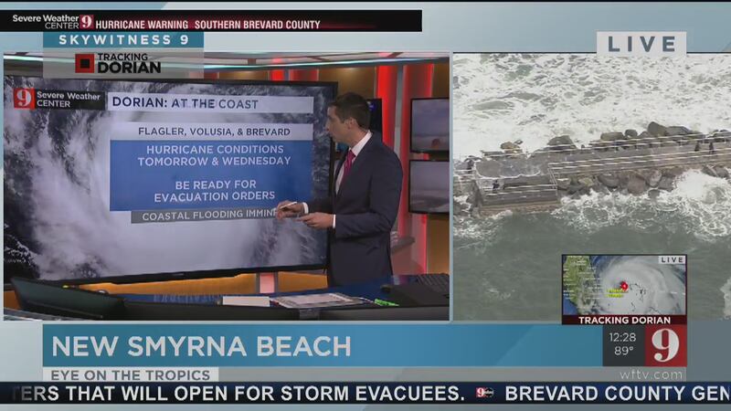
3:30 p.m. update: Channel 9 reporter Jeff Deal tweeted video that shows waves crashing onto a pier in Sebastian Inlet.
Video: Waves crashing over the pier at Sebastian Inlet. #WFTV #HurricaneDorian pic.twitter.com/DnBrAifuLJ
— Jeff Deal (@JDealWFTV) September 3, 2019
3 p.m. update: Chief meteorologist Tom Terry said wind gusts have reached 49 mph in Barefoot Bay in Brevard County as Hurricane Dorian skirts the Florida coast.
Sustained tropical storm force winds are now being felt in southern Brevard County. pic.twitter.com/9e60845SO7
— Rusty McCranie (@RMcCranieWFTV) September 3, 2019
2:45 p.m. update: Wildlife trapper Bob Cross showed Channel 9 reporter Jeff Levkulich a Florida cottonmouth in Seminole County and explained why venomous snakes tend to travel during periods of inclement weather.
Click here to watch the video, and click here to see a photo gallery of Florida's six species of venomous snakes.
#Dorian As rivers and lakes swell, remember that snakes like this cottonmouth water moccasin are on the move. Caught in a Seminole County neighborhood yesterday.#WFTV pic.twitter.com/Ws0bNlCSsP
— Jeff Levkulich (@jlevkulichWFTV) September 3, 2019
2 p.m. update: Hurricane Dorian is now moving at 5 mph heading northwest away from the Bahamas.
2pm advisory: Dorian holds steady with winds of 110mph. Forward speed continues to increase, now at 5mph. Dorian's eye is 46 miles wide. This is a very large storm and although the core will stay offshore, battering coastal winds are expected. pic.twitter.com/3pZYLTBqju
— Rusty McCranie (@RMcCranieWFTV) September 3, 2019
1 p.m. update: Channel 9 meteorologist Kassandra Crimi said Central Florida could experience wind gusts up to 50 or 60 mph this evening and overnight.
Turning gusty in a few spots this afternoon. We could see wind gusts of 50-60 mph this evening and overnight near the coastline. #DorianImpacts pic.twitter.com/mN7qMfOHHa
— Kassandra Crimi (@KCrimiWFTV) September 3, 2019
12:50 p.m. update: Channel 9 meteorologist Brian Shields is warning Floridians to stay out of the ocean leading up to the storm reiterating his warning from yesterday. Click here to read his message to those contemplating heading to the beach.
Please stay away from the water! I can't stress that enough.
— Brian Shields (@BrianWFTV) September 3, 2019
12:45 p.m. update: Power crews from across the country are staging in Florida to respond to possible power outages due to Hurricane Dorian.
.@insideFPL crews grabbing lunch as they await #HurricaneDorian ... check out the license plates (tweet 2) pic.twitter.com/4X7qEXaqWi
— Christopher Heath (@CHeathWFTV) September 3, 2019
Across the country, here in Florida pic.twitter.com/j1BJuSA0ZV
— Christopher Heath (@CHeathWFTV) September 3, 2019
12:30 p.m. update: Channel 9 reporter Johny Fernandez said there are 210 people in emergency shelters in Seminole County.
12:25 p.m. update: The Daytona Beach Waffle House is still open.
Daytona Beach @WaffleHouse : still open #HurricaneDorian pic.twitter.com/JJvXdWMUZ0
— Christopher Heath (@CHeathWFTV) September 3, 2019
Did you know the "Waffle House Index" is a thing that's (unofficially) used by FEMA to gauge disasters? Click here to find out how it works.
>>> LIVE RADAR: Track Hurricane Dorian live as it tracks just off Florida's coast <<<
12:15 p.m. update: Advent Health at New Smyrna Beach is OPEN, according to hospital officials.
An official from Advent Health at New Smyrna Beach said they wanted to clarify incorrect info given by state officials: the emergency room at this location is currently open #HurricaneDorian @WFTV
— Samantha Manning (@SamManningNews) September 3, 2019
11:25 a.m. update: There will be NO curfews in Orange County related to Hurricane Dorian, the county announced Tuesday. Click here to check which counties have and have not announced curfews.
11 a.m. update: As of the 11 a.m. track update Hurricane Dorian is now down to a Category 2 storm with 110 mph winds, Channel 9 meteorologist Kassandra Crimi said.
The new track says the storm is now moving 2 mph as it skirts the Florida coast. Crimi said its path keeps hurricane strength winds off the coast of Florida, with the coast expecting tropical storm force conditions.
Hurricane Dorian continues to weaken. It is now, a Category 2, winds 110mph. pic.twitter.com/9mcQBh8IQY
— Kassandra Crimi (@KCrimiWFTV) September 3, 2019
Meteorologist George Waldenberger said its current pace is the fastest the storm has moved in 32 hours.
Hurricane #Dorian now moving at 2 mph, its fastest forward motion in the past 32 hours. #WFTV pic.twitter.com/yTRE3W5kH3
— George Waldenberger (@GWaldenWFTV) September 3, 2019
10 a.m. update: Osceola County officials are providing an update on Hurricane Dorian preparations. Watch LIVE on Channel 9.
9:40 a.m. update: Need to pick up some last-minute supplies in Flagler County? Here's a list of which stores are still open Tuesday:
Still need to pick up some supplies? These are the stores that are open/closed in #FLAGLERCO. https://t.co/RZpNYQHx0a
— Megan Cruz (@MeganWFTV) September 3, 2019
9:10 a.m. update: Sen. Rick Scott is scheduled to call into Channel 9 for an interview to discuss Hurricane Dorian at 9:30 a.m. Click here or turn to Channel 9 to listen live.
>>> LIVE RADAR: Track Hurricane Dorian live as it tracks just off Florida's coast <<<
8:10 a.m. update: Channel 9 meteorologist Brian Shields said the latest track for Hurricane Dorian continues to keep the center of the storm off the coast of Florida sending tropical storm conditions to the coast.
Shields said the storm is now moving 1 mph northwest about 80 miles away from the coast of Florida. On its current track, Shields said the storm will be farther off the coast than Hurricane Matthew in 2016, which is good news for the coast.
8am advisory is in. Winds are 120mph. Just starting to crank up that move to the north. Forward speed should increase today. Dorian is forecast to remain ~80 miles offshore, farther than Matthew in 2016, but significant impacts still possible for the coast pic.twitter.com/ZV6Sf82k32
— Rusty McCranie (@RMcCranieWFTV) September 3, 2019
8 a.m. update: Traffic expert Racquel Asa spotted rain bands on her drive along Semoran Boulevard on her way to the Orange County EOC.
Hey @BrianShieldsTV. Rain bands on Semoran Blvd while heading to @OrangeCoFL EOC. @WFTV pic.twitter.com/SItKbO7zBj
— Racquel Asa (@RAsaWFTV) September 3, 2019
7:35 a.m. update: Channel 9 sports anchor Joe Kepner said there is sand available in Flagler Beach for last minute sandbags before Hurricane Dorian inches closer to the coast.
The sand is available next to Santa Maria Del Mar Church.
Fresh delivery of sand for anyone who needs last minute sandbags before #HurricaneDorian arrives.
— Joe Kepner (@JKepnerWFTV) September 3, 2019
Plenty of sand and bags available in the parking lot next to Santa Maria Del Mar church in Flagler Beach. pic.twitter.com/akMYJHZh7j
7 a.m. update: Channel 9 reporter Mike Springer said most stores are boarded up in Daytona Beach along A1A. He said police are in the area keeping an eye out for looters.
Stores boarded up all along A1A in #DaytonaBeach Not much traffic on the roads. Police are out keeping an eye on looters #HurricaneDorian pic.twitter.com/3Cp17xwsK7
— Mike Springer WFTV (@mspringerwftv) September 3, 2019
Light breeze; no rain as sun tries to peak through the clouds in #DaytonaBeach before #HuricaneDorian pic.twitter.com/Czj6H19aYN
— Mike Springer WFTV (@mspringerwftv) September 3, 2019
6:45 a.m. update: Channel 9 meteorologist Brian Shields said the current track keeps Hurricane Dorian almost 80 miles east of Cape Canaveral.
Here's the positive news: If this track holds, the center stays almost 80 miles east of the Cape. That keeps the hurricane winds offshore - over water. That is huge! But we need this to hold -or get better. Watching! See you on Channel 9! Thank you. Brian pic.twitter.com/uQ7DMbHxjp
— Brian Shields (@BrianWFTV) September 3, 2019
5:45 a.m. update: Channel 9 reporter Sarahbeth Ackerman said Brevard Emergency Management officials said there are currently 1,529 people and 139 pets inside Brevard County shelters.
They said there are 14 shelters that still have space.
PER @BrevardEOC: 1,529 people are inside #BrevardCounty shelters —-> Also 139 pets! 🐱🐶 Still lots of room! 14 shelters still have space. This includes pet friendly and special needs @WFTV #HurricaneDorain #trackingDorian #wftv pic.twitter.com/cDGRQONqaq
— Sarahbeth Ackerman (@SAckermanWFTV) September 3, 2019
5:30 a.m. update: The National Weather Service Melbourne tweeted a warning to coastal residents to stay out of the ocean due to "very dangerous" conditions.
5:15 am 9/3 | Dorian Update
— NWS Melbourne (@NWSMelbourne) September 3, 2019
Conditions at the beach at this time are VERY DANGEROUS! Do not attempt to go into the water, and stay away from the shore.
Tropical storm force winds arrive to the Treasure Coast this morning & to Brevard Co early this afternoon. pic.twitter.com/VLTrKByvnk
5 a.m. update: Channel 9 meteorologist Brian Shields said Hurricane Dorian's latest track now has the storm passing 70 miles off the coast of Florida.
"There is now no indication of landfall in Florida," Shields said.
He said the latest 5 a.m. track has the storm's entire forecast cone off shore.
"That is very good news," Shields said.
The new track is slated to bring tropical storm force winds to the coast with 40 to 60 mph wind gusts. Shields said beach erosion and storm surge will still be an issue along the coast.
NEW 5 AM TRACK: If this track holds, we are in better shape than Hurricane Matthew's track. Watching closely. Live on 9! See ya there! - Brian pic.twitter.com/ITWlNIsWbf
— Brian Shields (@BrianWFTV) September 3, 2019
4:30 a.m. update: Channel 9 meteorologist Brian Shields said Hurricane Dorian's track is now off shore.
He said that track means the storm should bring tropical storm conditions to the Florida coast.
Coastal flooding remains a concern, as well as storm surge and beach erosion problems.
1:30 a.m. update TUESDAY: Dorian continues to weaken, but remains a powerful hurricane. Maximum sustained winds are now at 125 mph, making it a Category 3 Hurricane. It will continue to gradually weaken. It is still stationary over the northern Bahamas.
1:30 a.m. actualizacion: Dorian ahora tiene vientos de 125 mph lo cual lo hace un huracán categoría 3 y continuará debilitandose, poco a poco. Resumirá su movimiento hoy martes. Aun continúa estacionado sobre la porción norte de las Bahamas.
HELPFUL LINKS TO HELP YOU PREPARE:
- Are you storm ready? Here's when, where you can get sandbags filled
- Stay informed during a storm: Emergency Operations Centers in Central Florida
- Orlando pet adoption service offering free microchipping in advance of Hurricane Dorian
- New to Florida? 9 helpful tips to get you through a hurricane

Cox Media Group


