
ORLANDO, Fla. — Channel 9 is tracking Hurricane Isaias as the Category 3 storm approaches the northern Gulf Coast ahead of an expected landfall Friday evening.
Our meteorologists are monitoring the storm’s strength, track and potential effects across Florida. Channel 9 crews are also positioned in Pensacola and Perdido Key to report on conditions before, during and after landfall.
Follow the latest developments below and watch Channel 9’s live coverage.
Have storm photos or video? Share them with Channel 9 here. Include where and when they were taken, and only record when it is safe.
What to know
- Storm strength: Hurricane Isaias remains a Category 3 storm with maximum sustained winds of 120 mph.
- Expected landfall: The center is expected to reach the western Florida Panhandle coast Friday evening.
- Gulf Coast impacts: Life-threatening storm surge, destructive winds, heavy rain, flooding and isolated tornadoes are possible.
- Central Florida: A direct impact is not expected, but fast-moving showers, isolated thunderstorms and a risk of isolated tornadoes remain possible.
- Evacuations: Escambia County ordered evacuations for Zones A and B, including Pensacola Beach.
- Channel 9 coverage: Shannon Butler and Dave Jordan are reporting from the Gulf Coast ahead of landfall.
Friday, Oct. 9
3 p.m. EDT | Tornado warning issued as Isaias nears Panhandle
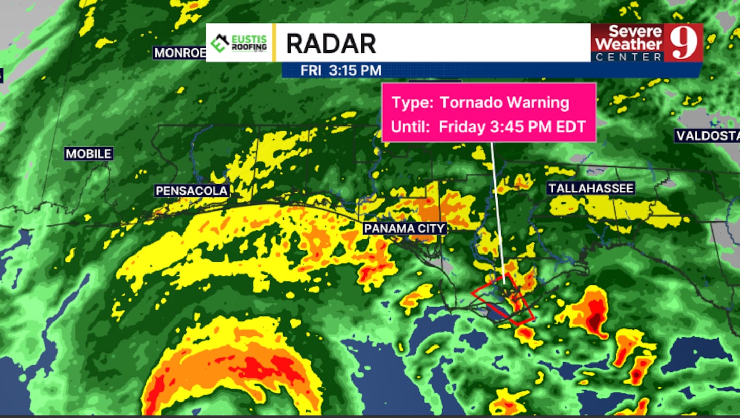
Hurricane Isaias is beginning to spread tropical-storm conditions across Florida’s western Panhandle.
The center of Isaias was about 125 miles south of Pensacola in the 3 p.m. update. Maximum sustained winds remain at 120 mph, keeping Isaias a major Category 3 hurricane.
A tornado warning is in effect for southeastern Gulf County and southwestern Franklin County until 3:45 p.m.
People in the warned area should seek shelter immediately in an interior room on the lowest floor of a sturdy building, away from windows.
The next update on Hurricane Isaias is expected at 4 p.m.
2:30 p.m. EDT | Tornado watch issued as Hurricane Isaias approaches landfall
Hurricane Isaias remains a powerful Category 3 storm with maximum sustained winds of 120 mph, according to the National Hurricane Center’s 2 p.m. advisory.
Some weakening is forecast as Isaias approaches the Gulf Coast, but the hurricane could still make landfall as a Category 3 storm over Florida’s western Panhandle.
Rainbands are already affecting much of the Panhandle and are expected to become more widespread and intense Friday afternoon and evening.
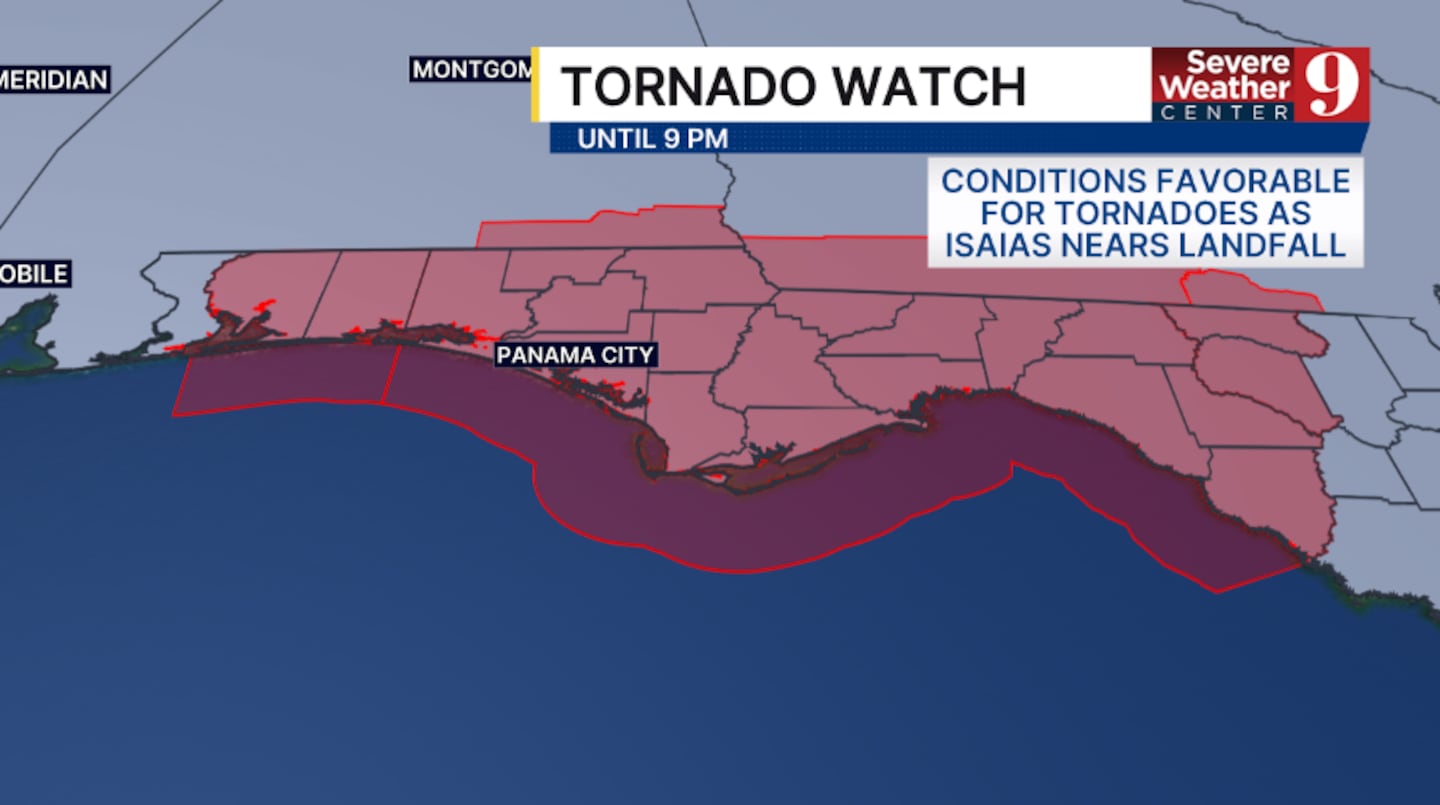
A tornado watch is in effect for much of the Florida Panhandle and Big Bend until 9 p.m. Conditions within the watch area are favorable for tornadoes as Isaias approaches landfall.
Landfall remains likely between Pensacola and Destin Friday evening or shortly after midnight.
The next National Hurricane Center update is scheduled for 3 p.m.
2:15 p.m. EDT | Hurricane Isaias closes in on Gulf Coast
Hurricane Isaias remains a Category 3 storm with maximum sustained winds of 120 mph as it moves toward the northern Gulf Coast.
The National Hurricane Center said life-threatening storm surge and destructive winds are likely along portions of the Florida Panhandle and Alabama coasts. The center of the storm is expected to reach the western Florida Panhandle coast Friday evening.
Channel 9 crews are in Pensacola and Perdido Key to document preparations and changing conditions ahead of landfall.

1 p.m. EDT | Isaias about 160 miles south of Pensacola
The center of Hurricane Isaias was about 160 miles south of Pensacola during the National Hurricane Center’s latest position update.
Isaias had maximum sustained winds of 120 mph and was moving north-northeast at 16 mph. Its minimum central pressure remained at 959 millibars.
A hurricane warning remains in effect from Ocean Springs, Mississippi, to the Bay-Gulf county line in Florida.
A storm surge warning extends from the mouth of the Mississippi River to the Suwannee River. Tropical storm warnings cover areas on either side of the hurricane warning.
Noon EDT | Saildrone records 104 mph gust near Isaias’ eyewall
A NOAA Saildrone positioned near the eyewall of Hurricane Isaias recorded a wind gust of 104 mph, according to the National Hurricane Center.
Hurricane-force winds extended up to 30 miles from the center, while tropical-storm-force winds extended up to 185 miles.
10 a.m. EDT | Escambia County prepares for dangerous storm surge
Officials warned that storm surge could reach 6 to 9 feet above ground in affected coastal areas from the Alabama-Florida border to Grayton Beach.
Escambia County ordered evacuations for Zones A and B, including Pensacola Beach. Officials warned that emergency responders may be unable to answer calls once sustained winds reach 39 mph or storm surge covers roads.
Residents can check their Escambia County evacuation zone here.
8:30 a.m. EDT | DeSantis warns of storm surge and wind damage
Gov. Ron DeSantis provided an update from Pensacola as officials prepared for Hurricane Isaias.
DeSantis urged residents in evacuation zones to follow local orders and warned that storm surge posed one of the greatest threats to life and property. Florida previously declared a state of emergency for 25 counties.
7:20 a.m. EDT | Isaias strengthens into a major hurricane
Hurricane Hunter aircraft found that Isaias had strengthened into a Category 3 hurricane with maximum sustained winds of 120 mph.
The milestone made Isaias the first major hurricane of the 2026 Atlantic season.
Click here to download our free news, weather and smart TV apps. And click here to stream Channel 9 Eyewitness News live.

©2026 Cox Media Group


